TopoQuest Logo
Do you find TopoQuest useful?
Help keep TopoQuest running and adding new maps/features by donating!
Bitcoin:  19c7KJd3qBynnjoSw5npx9KScwjBe4ifkT
Litecoin:  LXs6TkuXGGXo1vDsWCkWVdjQX94eUKd6ui
Home View Maps Find Maps Find Places Resources & Links


Luzena, Arizona Topographic Map

USGS Map Title: Luzena, AZ
USGS Map MRC: 32109C5
DRG (GeoTIFF) Download: o32109c5.tif


Neighboring USGS Topographic Map Quads:


  Monk Draw, AZ  
32109D6
 

  Fisher Hills, AZ  
32109D5
 

  Ryan Draw, AZ  
32109D4
 

  Railroad Pass, AZ  
32109C6
 

  Luzena, AZ  
32109C5
 

  Bowie, AZ  
32109C4
 

  Simmons Peak, AZ  
32109B6
 

  Dos Cabezas, AZ  
32109B5
 

  Bowie Mountain North, AZ  
32109B4


Map MRC Location:

N33°
W110°
N33°
W109°
H8 H7 H6 H5 H4 H3 H2 H1
G8 G7 G6 G5 G4 G3 G2 G1
F8 F7 F6 F5 F4 F3 F2 F1
E8 E7 E6 E5 E4 E3 E2 E1
D8 D7 D6 D5 D4 D3 D2 D1
C8 C7 C6 C5 C4 C3 C2 C1
B8 B7 B6 B5 B4 B3 B2 B1
A8 A7 A6 A5 A4 A3 A2 A1
N32°
W110°
N32°
W109°

Luzena, AZ USGS 1:24K Topographic Map Preview:
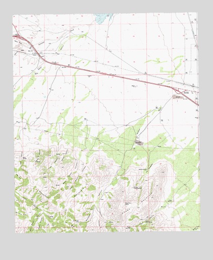
Luzena, AZ USGS Topographic Map
Click on map above to begin viewing in our Map Viewer.

This topographic map contains these locations and features:
Feature Name Type Latitude Longitude GNIS ID View Map
Adams CanyonValleyN32.3020°W109.6073°481View Map
Angle CanyonValleyN32.3006°W109.5956°657View Map
Bear CanyonValleyN32.2642°W109.5206°1111View Map
Brushy CanyonValleyN32.2626°W109.6059°2036View Map
Buckeye Apache MineMineN32.2542°W109.5848°21969View Map
Buckeye CanyonValleyN32.2881°W109.5509°2083View Map
Buckeye MillPopulated PlaceN32.2562°W109.5823°24338View Map
Buckeye WashStreamN32.3381°W109.5076°2090View Map
CCC Camp WellWellN32.2829°W109.5581°21973View Map
Cement CanyonValleyN32.2667°W109.5698°2667View Map
Cowboy Swimming HoleSpringN32.2754°W109.5458°3464View Map
East Eaton CanyonValleyN32.2962°W109.5734°4278View Map
Fuller BasinBasinN32.2823°W109.6228°4878View Map
Lower Bear SpringSpringN32.2562°W109.5373°7450View Map
Luzena InterchangeCrossingN32.3631°W109.6215°7552View Map
Luzena Railroad StationBuildingN32.3526°W109.5928°22130View Map
Maverick MountainSummitN32.2629°W109.5917°7785View Map
Monk DrawValleyN32.3581°W109.6184°8204View Map
Park CanyonValleyN32.3040°W109.6209°9215View Map
Railroad WashStreamN32.3715°W109.5695°9910View Map
Riley SpringSpringN32.2931°W109.6203°10279View Map
Rough CanyonValleyN32.3009°W109.5884°10514View Map
The HorseshoeBasinN32.2851°W109.5351°12333View Map
Trendt WindmillLocaleN32.2676°W109.5198°12702View Map
Upper Bear SpringSpringN32.2529°W109.5473°13064View Map
Walnut GulchValleyN32.3562°W109.6151°13315View Map
West Bowie InterchangeCrossingN32.3292°W109.5123°13479View Map
West Brushy CanyonValleyN32.2612°W109.6073°13483View Map
West Eaton CanyonValleyN32.2979°W109.5790°13492View Map
White Rock SpringSpringN32.2658°W109.5513°13661View Map
Woodrow WindmillLocaleN32.2854°W109.5362°13991View Map

Note: Coordinates in the location and feature list above are referenced to NAD83 datum.


Copyright (C) 2008-2025 Ryan Niemi / Sunset Dynamics ... All Rights Reserved