TopoQuest Logo
Do you find TopoQuest useful?
Help keep TopoQuest running and adding new maps/features by donating!
Bitcoin:  19c7KJd3qBynnjoSw5npx9KScwjBe4ifkT
Litecoin:  LXs6TkuXGGXo1vDsWCkWVdjQX94eUKd6ui
Home View Maps Find Maps Find Places Resources & Links


Bay Tambour, Louisiana Topographic Map

USGS Map Title: Bay Tambour, LA
USGS Map MRC: 29090C1
DRG (GeoTIFF) Download: o29090c1.tif


Neighboring USGS Topographic Map Quads:


  Golden Meadow Farms, LA  
29090D2
 

  Bay Dosgris, LA  
29090D1


  Mink Bayou, LA  
29090C2
 

  Bay Tambour, LA  
29090C1
 

  Barataria Pass, LA  
29089C8
 

  Leeville, LA  
29090B2
 

  Caminada Pass, LA  
29090B1
 

  Grand Isle, LA  
29089B8


Map MRC Location:

N30°
W91°
N30°
W90°
H8 H7 H6 H5 H4 H3 H2 H1
G8 G7 G6 G5 G4 G3 G2 G1
F8 F7 F6 F5 F4 F3 F2 F1
E8 E7 E6 E5 E4 E3 E2 E1
D8 D7 D6 D5 D4 D3 D2 D1
C8 C7 C6 C5 C4 C3 C2 C1
B8 B7 B6 B5 B4 B3 B2 B1
A8 A7 A6 A5 A4 A3 A2 A1
N29°
W91°
N29°
W90°

Bay Tambour, LA USGS 1:24K Topographic Map Preview:
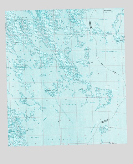
Bay Tambour, LA USGS Topographic Map
Click on map above to begin viewing in our Map Viewer.

This topographic map contains these locations and features:
Feature Name Type Latitude Longitude GNIS ID View Map
Andre IslandIslandN29.2652°W90.0431°559621View Map
Bay DesespereBayN29.2716°W90.0890°532359View Map
Bay JoyeuxBayN29.2883°W90.0365°559629View Map
Bay l'OursBayN29.3433°W90.0898°532344View Map
Bay LizetteBayN29.2586°W90.0970°532370View Map
Bay TambourBayN29.2874°W90.0615°532389View Map
Bay VasierBayN29.2947°W90.1179°559633View Map
Bayou AndreChannelN29.2633°W90.0359°532428View Map
Bayou Casse-TeteGutN29.3686°W90.0612°532490View Map
Bayou GarciGutN29.2508°W90.1209°532601View Map
Bayou l'OursGutN29.3208°W90.0623°532417View Map
Bayou RoseauGutN29.3524°W90.1206°532757View Map
Caminada BayBayN29.2536°W90.0573°553863View Map
Creole BayBayN29.3688°W90.0201°534238View Map
Daniels CutChannelN29.3522°W90.0251°534394View Map
Fishermans BayBayN29.3052°W90.0940°534967View Map
Fishermans Bay Gas FieldOilfieldN29.2730°W90.0951°557815View Map
Fricot BayouChannelN29.3516°W90.0354°535112View Map
Hatchet LakeBayN29.3461°W90.0676°535559View Map
Lake AndreBayN29.3186°W90.0748°559622View Map
Lake PierreBayN29.3141°W90.1195°538130View Map
Martigan PointCapeN29.2658°W90.0187°536912View Map
Oaks BayBayN29.3366°W90.1081°559702View Map
Palmetto BayouBayN29.3555°W90.1190°537944View Map
Point Des IlettesCapeN29.3005°W90.0142°538289View Map
Raccoon BayouGutN29.2874°W90.0195°538466View Map
Raccoon LakeLakeN29.2936°W90.0231°559711View Map
Raccoon Lake Gas FieldOilfieldN29.3047°W90.0148°557864View Map
Snake BayouBayN29.3583°W90.0769°539456View Map
West Champagne BayBayN29.3288°W90.0059°540306View Map

Note: Coordinates in the location and feature list above are referenced to NAD83 datum.


Copyright (C) 2008-2025 Ryan Niemi / Sunset Dynamics ... All Rights Reserved