TopoQuest Logo
Do you find TopoQuest useful?
Help keep TopoQuest running and adding new maps/features by donating!
Bitcoin:  19c7KJd3qBynnjoSw5npx9KScwjBe4ifkT
Litecoin:  LXs6TkuXGGXo1vDsWCkWVdjQX94eUKd6ui
Home View Maps Find Maps Find Places Resources & Links


Malibu Beach, California Topographic Map

USGS Map Title: Malibu Beach, CA
USGS Map MRC: 34118A6
DRG (GeoTIFF) Download: o34118a6.tif


Neighboring USGS Topographic Map Quads:


  Thousand Oaks, CA  
34118B7
 

  Calabasas, CA  
34118B6
 

  Canoga Park, CA  
34118B5
 

  Point Dume, CA  
34118A7
 

  Malibu Beach, CA  
34118A6
 

  Topanga, CA  
34118A5


Map MRC Location:

N35°
W119°
N35°
W118°
H8 H7 H6 H5 H4 H3 H2 H1
G8 G7 G6 G5 G4 G3 G2 G1
F8 F7 F6 F5 F4 F3 F2 F1
E8 E7 E6 E5 E4 E3 E2 E1
D8 D7 D6 D5 D4 D3 D2 D1
C8 C7 C6 C5 C4 C3 C2 C1
B8 B7 B6 B5 B4 B3 B2 B1
A8 A7 A6 A5 A4 A3 A2 A1
N34°
W119°
N34°
W118°

Malibu Beach, CA USGS 1:24K Topographic Map Preview:
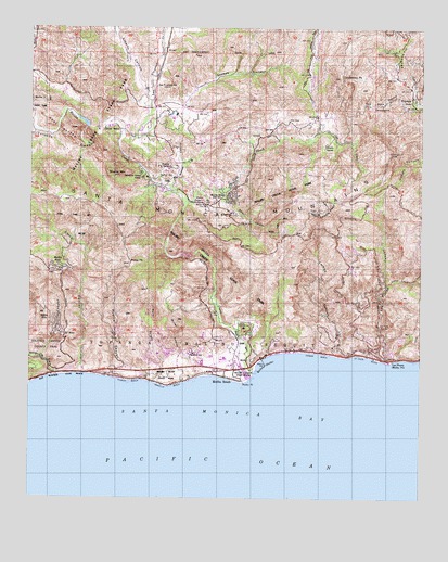
Malibu Beach, CA USGS Topographic Map
Click on map above to begin viewing in our Map Viewer.

This topographic map contains these locations and features:
Feature Name Type Latitude Longitude GNIS ID View Map
Amarillo BeachBeachN34.0297°W118.7062°256031View Map
Brents MountainSummitN34.0858°W118.7226°256033View Map
Brown RanchLocaleN34.1020°W118.7040°256034View Map
Calabasas PeakSummitN34.1122°W118.6520°256035View Map
Camp 8 HeliportAirportN34.0620°W118.6479°1653719View Map
Camp David GonzalesLocaleN34.0872°W118.7062°256045View Map
Camp GilmoreLocaleN34.0839°W118.7129°1733110View Map
Camp StausonLocaleN34.1042°W118.6412°256036View Map
Carbon BeachBeachN34.0389°W118.6587°256037View Map
Carbon CanyonValleyN34.0383°W118.6490°256038View Map
Century 001-071 DamDamN34.0984°W118.7333°1664048View Map
Century RanchLocaleN34.0981°W118.7265°256040View Map
Century ReservoirReservoirN34.0995°W118.7339°256042View Map
Cold CreekStreamN34.0781°W118.7015°256041View Map
Cold Creek Canyon PreserveParkN34.0945°W118.6487°1702783View Map
Corral BeachBeachN34.0331°W118.7331°256043View Map
Corral CanyonValleyN34.0336°W118.7343°256044View Map
Crater CampLocaleN34.0786°W118.6984°256046View Map
Dan Blocker BeachParkN34.0331°W118.7343°1702784View Map
Dark CanyonValleyN34.0822°W118.6901°256047View Map
Dry CanyonValleyN34.0381°W118.7468°256048View Map
El NidoPopulated PlaceN34.0436°W118.7393°1660598View Map
Goat ButtesSummitN34.0953°W118.7390°1660684View Map
Hughes-Malibu HeliportAirportN34.0445°W118.6948°1653720View Map
Kaslow Natural PreserveReserveN34.0903°W118.7450°2741220View Map
Kellers ShelterBayN34.0358°W118.6754°256051View Map
La Costa BeachBeachN34.0378°W118.6423°256052View Map
Las FloresPopulated PlaceN34.0372°W118.6359°1660897View Map
Las Flores CanyonValleyN34.0372°W118.6368°256053View Map
Las Flores RanchLocaleN34.0370°W118.6290°1682636View Map
Las Virgenes CreekStreamN34.0972°W118.7212°256055View Map
Las Virgenes SchoolLocaleN34.1092°W118.7104°256056View Map
Liberty CanyonValleyN34.1056°W118.7120°256057View Map
Liberty Canyon Natural PreserveReserveN34.1203°W118.7226°2741256View Map
Little Las Flores CanyonValleyN34.0572°W118.6368°256058View Map
Los Angeles County Fire Department Station 67BuildingN34.0781°W118.6941°256068View Map
Los Angeles County Fire Department Station 70BuildingN34.0385°W118.6497°2665144View Map
Los Angeles County Fire Department Station 88BuildingN34.0335°W118.6918°2665145View Map
Malibu Administrative Center HeliportAirportN34.0372°W118.6890°1653717View Map
Malibu BeachBeachN34.0320°W118.6884°1669875View Map
Malibu BeachPopulated PlaceN34.0328°W118.6884°1660978View Map
Malibu BluffsCliffN34.0320°W118.7023°1702791View Map
Malibu Bluffs ParkParkN34.0325°W118.7062°1733118View Map
Malibu BowlPopulated PlaceN34.0611°W118.7404°1660979View Map
Malibu Branch County of Los Angeles Public LibraryBuildingN34.0367°W118.6898°1733120View Map
Malibu CreekStreamN34.0317°W118.6798°256059View Map
Malibu Creek State ParkParkN34.1033°W118.7340°1733122View Map
Malibu HillsPopulated PlaceN34.0475°W118.7443°1660980View Map
Malibu LagoonLakeN34.0340°W118.6824°1702792View Map
Malibu Lagoon MuseumBuildingN34.0345°W118.6795°1702793View Map
Malibu Lagoon State BeachParkN34.0333°W118.6793°1702794View Map
Malibu PierLocaleN34.0361°W118.6759°1702795View Map
Malibu PointCapeN34.0311°W118.6823°256061View Map
Malibu Post OfficePost OfficeN34.0339°W118.6938°27833516View Map
Malibu ReservoirReservoirN34.0647°W118.6987°256062View Map
Marle CanyonValleyN34.0311°W118.7106°256064View Map
McAuley PeakSummitN34.0720°W118.7228°2771161View Map
Mesa PeakSummitN34.0625°W118.7190°256066View Map
Monte NidoPopulated PlaceN34.0808°W118.6870°256067View Map
Nike Site LA-78C (historical)MilitaryN34.0783°W118.6558°2129551View Map
Nike Site LA-78L (historical)MilitaryN34.0600°W118.6469°2129552View Map
Old Hope RanchLocaleN34.0920°W118.7140°1682630View Map
Old Rex Allen RanchLocaleN34.0995°W118.7001°1733126View Map
Pepperdine University - Malibu CampusSchoolN34.0411°W118.7083°1733121View Map
Perral Calabasas RanchLocaleN34.0897°W118.7165°1733129View Map
Perral RanchoLocaleN34.0883°W118.7012°1669896View Map
Puerco BeachBeachN34.0314°W118.7187°256071View Map
Puerco CanyonValleyN34.0320°W118.7140°256072View Map
Randge RanchLocaleN34.0467°W118.6801°1682648View Map
Red Rock CanyonValleyN34.1050°W118.6281°256073View Map
Saddle Creek RanchLocaleN34.0875°W118.6665°1733139View Map
Saddle PeakSummitN34.0758°W118.6584°256074View Map
Salvation Army CampLocaleN34.0850°W118.7148°256076View Map
Serra RetreatBuildingN34.0453°W118.6820°1661424View Map
Sleeper CanyonValleyN34.0817°W118.7059°256077View Map
Solstice CanyonValleyN34.0325°W118.7423°256078View Map
Solstice HillSummitN34.0345°W118.7498°1733142View Map
Stokes CanyonValleyN34.0956°W118.7176°256079View Map
Stunts RanchLocaleN34.0942°W118.6565°256080View Map
Summit UniversitySchoolN34.1008°W118.7051°1733144View Map
Tapia ParkParkN34.0847°W118.7065°256081View Map
The Crags Country ClubLocaleN34.0978°W118.7293°1669933View Map
Topanga LookoutLocaleN34.0922°W118.6359°256082View Map
Topanga ParkPopulated PlaceN34.1075°W118.6293°256084View Map
Triunfo CanyonValleyN34.0972°W118.7212°256085View Map
Udell Gorge Natural PreserveReserveN34.1033°W118.7448°2741341View Map
Webster SchoolSchoolN34.0389°W118.6981°256063View Map
Winter CanyonValleyN34.0356°W118.6979°256088View Map

Note: Coordinates in the location and feature list above are referenced to NAD83 datum.


Copyright (C) 2008-2024 Ryan Niemi / Sunset Dynamics ... All Rights Reserved