TopoQuest Logo
Do you find TopoQuest useful?
Help keep TopoQuest running and adding new maps/features by donating!
Bitcoin:  19c7KJd3qBynnjoSw5npx9KScwjBe4ifkT
Litecoin:  LXs6TkuXGGXo1vDsWCkWVdjQX94eUKd6ui
Home View Maps Find Maps Find Places Resources & Links


Man, West Virginia Topographic Map

USGS Map Title: Man, WV
USGS Map MRC: 37081F8
DRG (GeoTIFF) Download: o37081f8.tif


Neighboring USGS Topographic Map Quads:


  Holden, WV  
37082G1
 

  Logan, WV  
37081G8
 

  Amherstdale, WV  
37081G7
 

  Barnabus, WV  
37082F1
 

  Man, WV  
37081F8
 

  Mallory, WV  
37081F7
 

  Majestic, KY  
37082E1
 

  Wharncliffe, WV  
37081E8
 

  Gilbert, WV  
37081E7


Map MRC Location:

N38°
W82°
N38°
W81°
H8 H7 H6 H5 H4 H3 H2 H1
G8 G7 G6 G5 G4 G3 G2 G1
F8 F7 F6 F5 F4 F3 F2 F1
E8 E7 E6 E5 E4 E3 E2 E1
D8 D7 D6 D5 D4 D3 D2 D1
C8 C7 C6 C5 C4 C3 C2 C1
B8 B7 B6 B5 B4 B3 B2 B1
A8 A7 A6 A5 A4 A3 A2 A1
N37°
W82°
N37°
W81°

Man, WV USGS 1:24K Topographic Map Preview:
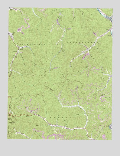
Man, WV USGS Topographic Map
Click on map above to begin viewing in our Map Viewer.

This topographic map contains these locations and features:
Feature Name Type Latitude Longitude GNIS ID View Map
Big BranchStreamN37.6637°W81.9396°1535785View Map
Browning CemeteryCemeteryN37.6296°W81.9798°1536417View Map
Browning ForkStreamN37.6359°W81.9068°1536423View Map
Browning Fork ChurchChurchN37.6571°W81.9154°1536424View Map
Browning-Grimmet CemeteryCemeteryN37.6868°W81.8772°2586276View Map
Buffalo CreekStreamN37.7415°W81.8776°1536626View Map
Buffalo Creek Memorial Public LibraryBuildingN37.7351°W81.8752°2727244View Map
Conley BranchStreamN37.7132°W81.9879°1537570View Map
Coon BranchStreamN37.6398°W81.9496°1537614View Map
Coon KnobSummitN37.6384°W81.9660°1554185View Map
Crystal BlockPopulated PlaceN37.7079°W81.9885°1554235View Map
Deadman BranchStreamN37.6632°W81.9954°1538089View Map
DonPopulated PlaceN37.7421°W81.9390°1554317View Map
Donaldson BranchStreamN37.6437°W81.9548°1538264View Map
Douglas School (historical)SchoolN37.7496°W81.9982°1538298View Map
Ellis CemeteryCemeteryN37.6473°W81.9043°1538672View Map
Gilbert High School (historical)SchoolN37.6359°W81.9122°2088211View Map
HampdenPopulated PlaceN37.6396°W81.9487°1554632View Map
Hampden Post OfficePost OfficeN37.6382°W81.9423°1728783View Map
Hatfield CemeteryCemeteryN37.6273°W81.9007°1540054View Map
Hatfield CemeteryCemeteryN37.6387°W81.9410°1540055View Map
Hatfield CemeteryCemeteryN37.7043°W81.9923°1540056View Map
Henry BranchStreamN37.6490°W81.9065°1540152View Map
Hensley HeightsPopulated PlaceN37.7293°W81.8796°1554685View Map
Horsepen MountainSummitN37.6407°W81.9935°1540506View Map
Laurel BranchStreamN37.7298°W81.9332°1541368View Map
Left ForkStreamN37.6904°W81.9962°1541617View Map
Lefthand ForkStreamN37.7112°W81.9026°1541771View Map
Lick BranchStreamN37.7121°W81.9037°1541841View Map
Logan County Fire Department Station 2BuildingN37.7307°W81.8756°2577610View Map
Lower Dempsey BranchStreamN37.7079°W81.9873°1542536View Map
ManPopulated PlaceN37.7398°W81.8776°1542706View Map
Man High SchoolSchoolN37.7305°W81.8768°1542707View Map
Mingo Lookout TowerTowerN37.6407°W81.9935°1559879View Map
Mountain ViewLocaleN37.6498°W81.9948°1543874View Map
Oldhouse BranchStreamN37.6376°W81.9404°1544382View Map
Oldhouse BranchStreamN37.7154°W81.8968°1544385View Map
Perry BranchStreamN37.6387°W81.9465°1544718View Map
Pit BranchStreamN37.7362°W81.9410°1544963View Map
Right Fork Browning ForkStreamN37.6565°W81.9148°1545616View Map
Right Fork Island CreekStreamN37.6898°W81.9962°1545652View Map
Right Fork Sandlick CreekStreamN37.6854°W81.8754°1545696View Map
Road ForkStreamN37.6723°W81.8912°1742605View Map
Rockhouse BranchStreamN37.6723°W81.8912°1742607View Map
Rockhouse CreekStreamN37.7290°W81.8754°1545978View Map
Sarah AnnPopulated PlaceN37.7112°W81.9873°1555572View Map
Sarah Ann Census Designated PlaceCensusN37.7085°W81.9881°2586879View Map
Sarah Ann Post OfficePost OfficeN37.7130°W81.9889°2774627View Map
Sharkey BranchStreamN37.6484°W81.9673°1546621View Map
Sharon HeightsPopulated PlaceN37.6379°W81.9371°1555600View Map
Sheep HollowValleyN37.7068°W81.9035°1546651View Map
Smith BranchStreamN37.6354°W81.9304°1546956View Map
Smith CemeteryCemeteryN37.6368°W81.9296°1546961View Map
South Man Elementary SchoolSchoolN37.7379°W81.8767°1742617View Map
Spring BranchStreamN37.7101°W81.9362°1547162View Map
Spring BranchStreamN37.7221°W81.8918°1547163View Map
Stirrat Number 15 ImpoundmentReservoirN37.7284°W81.9865°1558969View Map
Stirrat Number 15 Waste Embankment DamDamN37.7284°W81.9865°1558968View Map
Superior BottomPopulated PlaceN37.7490°W81.9993°1555759View Map
TamcliffPopulated PlaceN37.6384°W81.8765°1547883View Map
Town of ManCivilN37.7422°W81.8817°2391283View Map
Upper Dempsey BranchStreamN37.6865°W81.9965°1548513View Map
Upper Pete BranchStreamN37.6257°W81.8990°1548542View Map
West Virginia State Police Troop 5 - Gilbert DetachmentBuildingN37.6352°W81.9208°2728070View Map

Note: Coordinates in the location and feature list above are referenced to NAD83 datum.


Copyright (C) 2008-2024 Ryan Niemi / Sunset Dynamics ... All Rights Reserved