TopoQuest Logo
Do you find TopoQuest useful?
Help keep TopoQuest running and adding new maps/features by donating!
Bitcoin:  19c7KJd3qBynnjoSw5npx9KScwjBe4ifkT
Litecoin:  LXs6TkuXGGXo1vDsWCkWVdjQX94eUKd6ui
Home View Maps Find Maps Find Places Resources & Links


Many Point Lake, Minnesota Topographic Map

USGS Map Title: Many Point Lake, MN
USGS Map MRC: 47095A5
DRG (GeoTIFF) Download: o47095a5.tif


Neighboring USGS Topographic Map Quads:


  Snider Lake, MN  
47095B6
 

  Tulaby Lake, MN  
47095B5
 

  Long Lost Lake, MN  
47095B4
 

  Strawberry Lake, MN  
47095A6
 

  Many Point Lake, MN  
47095A5
 

  Big Rush Lake, MN  
47095A4
 

  Flat Lake, MN  
46095H6
 

  Height of Land Lake, MN  
46095H5
 

  Ponsford, MN  
46095H4


Map MRC Location:

N48°
W96°
N48°
W95°
H8 H7 H6 H5 H4 H3 H2 H1
G8 G7 G6 G5 G4 G3 G2 G1
F8 F7 F6 F5 F4 F3 F2 F1
E8 E7 E6 E5 E4 E3 E2 E1
D8 D7 D6 D5 D4 D3 D2 D1
C8 C7 C6 C5 C4 C3 C2 C1
B8 B7 B6 B5 B4 B3 B2 B1
A8 A7 A6 A5 A4 A3 A2 A1
N47°
W96°
N47°
W95°

Many Point Lake, MN USGS 1:24K Topographic Map Preview:
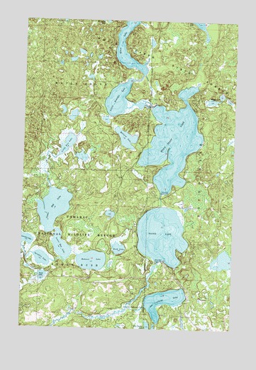
Many Point Lake, MN USGS Topographic Map
Click on map above to begin viewing in our Map Viewer.

This topographic map contains these locations and features:
Feature Name Type Latitude Longitude GNIS ID View Map
Beaver LakeLakeN47.0927°W95.5143°639836View Map
Bush LakeLakeN47.0327°W95.5673°640694View Map
Dry LakeReservoirN47.0300°W95.5803°1776891View Map
Dry Lake DamDamN47.0300°W95.5803°1776890View Map
Ice Cracking LakeReservoirN47.0115°W95.5401°645323View Map
Little Bemidji LakeReservoirN47.0905°W95.5503°646761View Map
Little Bemidji Lake DamDamN47.0933°W95.5503°1775917View Map
Little Rice LakeLakeN47.0734°W95.6007°646903View Map
Lower Egg LakeLakeN47.0322°W95.6009°647249View Map
Mallard LakeLakeN47.0772°W95.5645°647407View Map
Many Point LakeReservoirN47.0762°W95.5369°647460View Map
Many Point Lake DamDamN47.0583°W95.5403°1775915View Map
Round LakeReservoirN47.0382°W95.5421°650356View Map
Round Lake DamDamN47.0300°W95.5586°1775914View Map
Rush LakeLakeN47.0213°W95.6128°650403View Map
Spindler LakeLakeN47.0280°W95.6130°652391View Map
Tamarac Resort and CampgroundLocaleN47.0397°W95.5569°2108727View Map
Tamarac WildernessReserveN47.0682°W95.5987°2035322View Map
Township of Eagle ViewCivilN47.1077°W95.6152°664021View Map
Upper Egg LakeLakeN47.0447°W95.6054°653546View Map
Waboose LakeLakeN47.0275°W95.5831°653703View Map
Whaley's Resort and Camp SiteLocaleN47.0881°W95.5500°2108728View Map

Note: Coordinates in the location and feature list above are referenced to NAD83 datum.


Copyright (C) 2008-2025 Ryan Niemi / Sunset Dynamics ... All Rights Reserved