TopoQuest Logo
Do you find TopoQuest useful?
Help keep TopoQuest running and adding new maps/features by donating!
Bitcoin:  19c7KJd3qBynnjoSw5npx9KScwjBe4ifkT
Litecoin:  LXs6TkuXGGXo1vDsWCkWVdjQX94eUKd6ui
Home View Maps Find Maps Find Places Resources & Links


Mapleton, Iowa Topographic Map

USGS Map Title: Mapleton, IA
USGS Map MRC: 42095B7
DRG (GeoTIFF) Download: o42095b7.tif


Neighboring USGS Topographic Map Quads:


  Oto, IA  
42095C8
 

  Correctionville SE, IA  
42095C7
 

  Holstein SW, IA  
42095C6
 

  Smithland, IA  
42095B8
 

  Mapleton, IA  
42095B7
 

  Danbury, IA  
42095B6
 

  Castana, IA  
42095A8
 

  Mapleton SE, IA  
42095A7
 

  Ute, IA  
42095A6


Map MRC Location:

N43°
W96°
N43°
W95°
H8 H7 H6 H5 H4 H3 H2 H1
G8 G7 G6 G5 G4 G3 G2 G1
F8 F7 F6 F5 F4 F3 F2 F1
E8 E7 E6 E5 E4 E3 E2 E1
D8 D7 D6 D5 D4 D3 D2 D1
C8 C7 C6 C5 C4 C3 C2 C1
B8 B7 B6 B5 B4 B3 B2 B1
A8 A7 A6 A5 A4 A3 A2 A1
N42°
W96°
N42°
W95°

Mapleton, IA USGS 1:24K Topographic Map Preview:
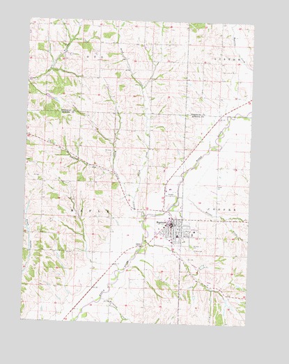
Mapleton, IA USGS Topographic Map
Click on map above to begin viewing in our Map Viewer.

This topographic map contains these locations and features:
Feature Name Type Latitude Longitude GNIS ID View Map
City of MapletonCivilN42.1671°W95.7905°2395843View Map
Dutch CreekStreamN42.1764°W95.8142°456080View Map
Faith Bible ChurchChurchN42.1658°W95.7886°1981878View Map
Flanigan Brothers Grain Company ElevatorLocaleN42.1750°W95.7870°1981870View Map
Heisler CemeteryCemeteryN42.1816°W95.7686°457382View Map
Heisler CreekStreamN42.1778°W95.7900°457383View Map
James G Whiting Memorial FieldAirportN42.1801°W95.7938°466861View Map
Maple Valley - Anthon Oto High SchoolSchoolN42.1604°W95.7895°1981883View Map
Maple Valley Medical ClinicHospitalN42.1661°W95.7920°1981875View Map
MapletonPopulated PlaceN42.1658°W95.7931°458787View Map
Mapleton (historical)LocaleN42.1667°W95.7964°1981864View Map
Mapleton Ambulance ServiceBuildingN42.1605°W95.7968°2599787View Map
Mapleton City HallBuildingN42.1661°W95.7914°1981873View Map
Mapleton Community CenterBuildingN42.1661°W95.7914°1981872View Map
Mapleton Elementary SchoolSchoolN42.1614°W95.7897°1981884View Map
Mapleton Fire DepartmentBuildingN42.1649°W95.7955°1981866View Map
Mapleton Grain Company ElevatorLocaleN42.1667°W95.7961°1981868View Map
Mapleton Police DepartmentBuildingN42.1661°W95.7910°1981871View Map
Mapleton Post OfficePost OfficeN42.1661°W95.7911°1981867View Map
Mapleton Public LibraryBuildingN42.1650°W95.7900°1981869View Map
McCleerey CreekStreamN42.1347°W95.8308°458889View Map
Midwest Health and Wellness CenterHospitalN42.1597°W95.7922°1981874View Map
Mount Hope CemeteryCemeteryN42.1572°W95.7817°459298View Map
Pumpkin RunStreamN42.1867°W95.8253°460474View Map
Saint John's United Methodist ChurchChurchN42.1647°W95.7883°1981882View Map
Saint Mary's Catholic ChurchChurchN42.1675°W95.7872°1981881View Map
Saint Marys CemeteryCemeteryN42.1555°W95.7817°461169View Map
Saint Matthew Lutheran ChurchChurchN42.1608°W95.7917°1981879View Map
Saint Peter's United ChurchChurchN42.1633°W95.7914°1981880View Map
Schoenjahn Wildlife PreserveParkN42.1625°W95.8086°1981822View Map
Simmons CreekStreamN42.1686°W95.8070°461643View Map
Township of MapleCivilN42.1683°W95.8456°468341View Map
Vision Care ClinicHospitalN42.1655°W95.7922°1981876View Map
Willow CreekStreamN42.1767°W95.8142°463073View Map
Willow Vale Golf ClubLocaleN42.1708°W95.7961°1981865View Map
Wyant Spinal ClinicHospitalN42.1661°W95.7920°1981877View Map

Note: Coordinates in the location and feature list above are referenced to NAD83 datum.


Copyright (C) 2008-2025 Ryan Niemi / Sunset Dynamics ... All Rights Reserved