TopoQuest Logo
Do you find TopoQuest useful?
Help keep TopoQuest running and adding new maps/features by donating!
Bitcoin:  19c7KJd3qBynnjoSw5npx9KScwjBe4ifkT
Litecoin:  LXs6TkuXGGXo1vDsWCkWVdjQX94eUKd6ui
Home View Maps Find Maps Find Places Resources & Links


Marlborough, Michigan Topographic Map

USGS Map Title: Marlborough, MI
USGS Map MRC: 43085G7
DRG (GeoTIFF) Download: o43085g7.tif


Neighboring USGS Topographic Map Quads:


  Townsend Lake, MI  
43085H8
 

  Baldwin, MI  
43085H7
 

  Chase, MI  
43085H6
 

  Big Star Lake, MI  
43085G8
 

  Marlborough, MI  
43085G7
 

  Whipple Lake, MI  
43085G6
 

  Walkup Lake, MI  
43085F8
 

  Woodland Park, MI  
43085F7
 

  Woodville, MI  
43085F6


Map MRC Location:

N44°
W86°
N44°
W85°
H8 H7 H6 H5 H4 H3 H2 H1
G8 G7 G6 G5 G4 G3 G2 G1
F8 F7 F6 F5 F4 F3 F2 F1
E8 E7 E6 E5 E4 E3 E2 E1
D8 D7 D6 D5 D4 D3 D2 D1
C8 C7 C6 C5 C4 C3 C2 C1
B8 B7 B6 B5 B4 B3 B2 B1
A8 A7 A6 A5 A4 A3 A2 A1
N43°
W86°
N43°
W85°

Marlborough, MI USGS 1:24K Topographic Map Preview:
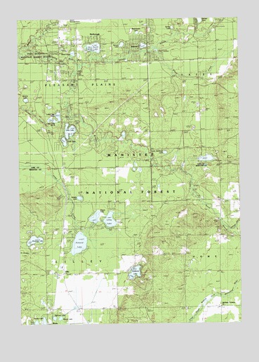
Marlborough, MI USGS Topographic Map
Click on map above to begin viewing in our Map Viewer.

This topographic map contains these locations and features:
Feature Name Type Latitude Longitude GNIS ID View Map
Alderson Post Office (historical)Post OfficeN43.8072°W85.8500°2541863View Map
Alderson Station (historical)LocaleN43.8072°W85.8500°2541802View Map
Baldwin Assembly of God ChurchChurchN43.8389°W85.8508°2513344View Map
Blood CreekStreamN43.8625°W85.7967°1619253View Map
Brown Trout Historical MarkerParkN43.8558°W85.8503°2513398View Map
Conna-Mara LakeLakeN43.8175°W85.7686°2513397View Map
Curtice CemeteryCemeteryN43.8003°W85.7606°1619644View Map
Forks Public AccessLocaleN43.8531°W85.8420°1622311View Map
Grace Lutheran ChurchChurchN43.8639°W85.8594°2513345View Map
Houseman LakeLakeN43.7845°W85.8667°1620256View Map
Jackson CornersLocaleN43.7567°W85.7614°1620347View Map
Jewell Post Office (historical)Post OfficeN43.8139°W85.8506°2541831View Map
Jewell Station (historical)LocaleN43.8139°W85.8511°2541797View Map
LilleyPopulated PlaceN43.7708°W85.8506°1620514View Map
Lilley CemeteryCemeteryN43.7714°W85.8594°2541875View Map
Lilley LakeLakeN43.7924°W85.8239°1620515View Map
Lilley Post Office (historical)Post OfficeN43.7708°W85.8506°2541828View Map
Lilley StationLocaleN43.7708°W85.8528°2541804View Map
Little Bullhead LakeLakeN43.8201°W85.7922°1620542View Map
Little Lake Number OneLakeN43.8293°W85.8461°1620560View Map
Little Lake Number ThreeLakeN43.8336°W85.8559°1620562View Map
Little Lake Number TwoLakeN43.8354°W85.8524°1620561View Map
Little South Branch Pere Marquette RiverStreamN43.8564°W85.8417°1620586View Map
Marlboro Post Office (historical)Post OfficeN43.8647°W85.8417°2513373View Map
MarlboroughPopulated PlaceN43.8647°W85.8417°1620711View Map
Marlborough StationLocaleN43.8647°W85.8542°2513354View Map
Middle Branch Pere Marquette RiverStreamN43.8561°W85.8417°1620810View Map
Mowby LakeLakeN43.7512°W85.8615°1620921View Map
North LakeLakeN43.8634°W85.8317°1621046View Map
North PondLakeN43.8611°W85.8438°1621056View Map
Oaklawn CemeteryCemeteryN43.8725°W85.8034°1621088View Map
Pease CreekStreamN43.7886°W85.7567°1621180View Map
Pettibone LakeLakeN43.7711°W85.8100°1621221View Map
Pettibone Lake ParkParkN43.7731°W85.8125°2542007View Map
Pettibone Park CampgroundLocaleN43.7736°W85.8125°2542142View Map
Pickerel LakeLakeN43.7829°W85.8415°1621228View Map
Pickerel Lakeside Campground and CottagesLocaleN43.7831°W85.8461°2500853View Map
Railroad LakeLakeN43.7524°W85.8558°1621335View Map
Rattlesnake LakeLakeN43.8693°W85.8073°1621350View Map
Riverside SchoolSchoolN43.7861°W85.7659°636015View Map
Sanborn CreekStreamN43.8600°W85.8723°1621500View Map
Schultz LakeLakeN43.8017°W85.8409°1621544View Map
Shrine of the PinesParkN43.8553°W85.8483°2513323View Map
Sisson LakeLakeN43.7935°W85.8322°1621624View Map
South LakeLakeN43.8250°W85.8492°1621703View Map
Spring LakeLakeN43.8713°W85.7874°1621739View Map
Spruce LakeLakeN43.8645°W85.8161°1621744View Map
Stevens LakeLakeN43.8421°W85.8709°1621772View Map
Switzer LakeLakeN43.8743°W85.7717°1621846View Map
Township of LilleyCivilN43.7707°W85.8596°1626615View Map
Township of Pleasant PlainsCivilN43.8576°W85.8601°1626916View Map
Watermill LakeLakeN43.8640°W85.8040°1617038View Map
Whispering Oaks Campground and CabinsLocaleN43.8636°W85.8500°2513328View Map
Woods LakeLakeN43.7524°W85.8525°1622214View Map

Note: Coordinates in the location and feature list above are referenced to NAD83 datum.


Copyright (C) 2008-2024 Ryan Niemi / Sunset Dynamics ... All Rights Reserved