TopoQuest Logo
Do you find TopoQuest useful?
Help keep TopoQuest running and adding new maps/features by donating!
Bitcoin:  19c7KJd3qBynnjoSw5npx9KScwjBe4ifkT
Litecoin:  LXs6TkuXGGXo1vDsWCkWVdjQX94eUKd6ui
Home View Maps Find Maps Find Places Resources & Links


Marshfield, Vermont Topographic Map

USGS Map Title: Marshfield, VT
USGS Map MRC: 44072C3
DRG (GeoTIFF) Download: o44072c3.tif


Neighboring USGS Topographic Map Quads:


  Woodbury, VT  
44072D4
 

  Cabot, VT  
44072D3


  Plainfield, VT  
44072C4
 

  Marshfield, VT  
44072C3


  Barre East, VT  
44072B4
 

  Knox Mountain, VT  
44072B3
 

  Groton, VT  
44072B2


Map MRC Location:

N45°
W73°
N45°
W72°
H8 H7 H6 H5 H4 H3 H2 H1
G8 G7 G6 G5 G4 G3 G2 G1
F8 F7 F6 F5 F4 F3 F2 F1
E8 E7 E6 E5 E4 E3 E2 E1
D8 D7 D6 D5 D4 D3 D2 D1
C8 C7 C6 C5 C4 C3 C2 C1
B8 B7 B6 B5 B4 B3 B2 B1
A8 A7 A6 A5 A4 A3 A2 A1
N44°
W73°
N44°
W72°

Marshfield, VT USGS 1:24K Topographic Map Preview:
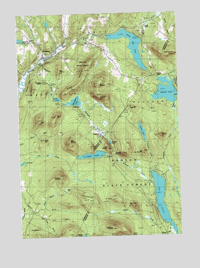
Marshfield, VT USGS Topographic Map
Click on map above to begin viewing in our Map Viewer.

This topographic map contains these locations and features:
Feature Name Type Latitude Longitude GNIS ID View Map
Bailey PondReservoirN44.3274°W72.3446°1456208View Map
Bailey Pond DamDamN44.3273°W72.3454°1766493View Map
Beaver BrookStreamN44.2589°W72.2645°1456336View Map
Beaver PondLakeN44.2806°W72.2549°1456359View Map
Big Deer CampgroundLocaleN44.2881°W72.2690°1919439View Map
Big Deer Mountain TrailTrailN44.3137°W72.2704°1919440View Map
Big Deer Recreation AreaParkN44.2873°W72.2690°1919441View Map
Blake HillSummitN44.3223°W72.2865°1456463View Map
Boulder BeachBeachN44.2726°W72.2634°1919443View Map
Boulder Beach Recreation AreaParkN44.2726°W72.2632°1919444View Map
Burnt MountainSummitN44.3356°W72.3123°1456674View Map
Christ Covenant MinistriesChurchN44.3537°W72.3549°1919021View Map
Coldwater BrookStreamN44.2826°W72.2670°1456977View Map
Coldwater Brook TrailTrailN44.2964°W72.2620°1919471View Map
Cream Pot MeadowFlatN44.3087°W72.3543°1457055View Map
Debby HillSummitN44.3045°W72.3557°1457134View Map
Deer MountainSummitN44.3067°W72.2640°1457139View Map
Depot BrookStreamN44.2501°W72.2612°1457151View Map
Devils HillSummitN44.3178°W72.3462°1457162View Map
Drew MountainSummitN44.3467°W72.3187°1457192View Map
EdgewaterPopulated PlaceN44.3237°W72.3343°1457341View Map
Federated ChurchChurchN44.3512°W72.3529°1919055View Map
Goslant PondLakeN44.3027°W72.3041°1457582View Map
Groton Nature CenterBuildingN44.2867°W72.2668°1919525View Map
Groton Pond DamDamN44.2501°W72.2529°1766455View Map
Groton State ForestForestN44.2759°W72.2795°1457658View Map
Groton State Forest Nature TrailTrailN44.2867°W72.2668°1919527View Map
Hardwood MountainSummitN44.2839°W72.3448°1457732View Map
Hardwood RidgeRidgeN44.2712°W72.3270°1457734View Map
Hooker MountainSummitN44.3512°W72.2579°1457884View Map
Hosmer Brook TrailTrailN44.2942°W72.2704°1919549View Map
Hudson CemeteryCemeteryN44.3490°W72.3577°1919077View Map
Jaquith Public LibraryBuildingN44.3481°W72.3537°1919084View Map
Kettle MountainSummitN44.3028°W72.3362°1458077View Map
Kettle PondLakeN44.2955°W72.3179°1458078View Map
Kettle Pond Group Camping AreaLocaleN44.2945°W72.3079°1919565View Map
Kettle Pond TrailTrailN44.2951°W72.3168°1919566View Map
Kidder BrookStreamN44.3739°W72.2654°1457882View Map
Knob Hill PondLakeN44.3606°W72.3731°1458121View Map
Laird PondReservoirN44.2914°W72.3737°1458131View Map
Laird Pond DamDamN44.2906°W72.3748°1766587View Map
Lake GrotonLakeN44.2699°W72.2649°1457659View Map
LakesidePopulated PlaceN44.2517°W72.2623°1460429View Map
Lanes BrookStreamN44.2645°W72.3654°1458158View Map
LanesboroPopulated PlaceN44.3073°W72.3112°1458159View Map
Little Deer MountainSummitN44.2976°W72.2782°1458234View Map
Little Deer TrailTrailN44.2995°W72.2779°1919568View Map
Little Spruce MountainSummitN44.2545°W72.3029°1458254View Map
Lords HillSummitN44.3153°W72.3595°1458289View Map
Loveland LedgeBenchN44.3356°W72.3673°1458295View Map
Maple Hill-Bolles CemeteryCemeteryN44.2641°W72.3655°1919108View Map
MarshfieldPopulated PlaceN44.3509°W72.3540°1458364View Map
Marshfield BrookStreamN44.3478°W72.3587°1458365View Map
Marshfield Fire DepartmentBuildingN44.3516°W72.3464°2121373View Map
Marshfield MountainSummitN44.3284°W72.3118°1458366View Map
Marshfield Municipal ForestForestN44.3459°W72.3120°1919110View Map
Marshfield Number 6 DamDamN44.3584°W72.3045°1766373View Map
Marshfield Post OfficePost OfficeN44.3516°W72.3476°1919111View Map
Marshfield StationLocaleN44.3373°W72.3554°1458368View Map
Mays MountainSummitN44.3428°W72.3448°1458386View Map
Mollys BrookStreamN44.3595°W72.3369°1458512View Map
Mollys FallsFallsN44.3570°W72.3420°1458513View Map
Mollys Falls PondReservoirN44.3584°W72.3045°1766374View Map
Mud PondLakeN44.2773°W72.3388°1458612View Map
New Discovery CampgroundLocaleN44.3201°W72.2898°1919608View Map
New Discovery CemeteryCemeteryN44.3432°W72.2965°1458669View Map
New Discovery Recreation AreaParkN44.3201°W72.2887°1919609View Map
Osmore BrookStreamN44.2853°W72.2726°1457902View Map
Osmore PondLakeN44.3085°W72.2786°1458858View Map
Osmore Pond Hiking LoopTrailN44.3142°W72.2809°1919635View Map
Osmore Pond Picnic ShelterLocaleN44.3098°W72.2815°1919636View Map
Owls Head TrailTrailN44.2962°W72.2945°1919637View Map
Owlshead MountainSummitN44.2964°W72.2954°1458867View Map
Peacham CornerPopulated PlaceN44.3401°W72.2684°1460443View Map
Peacham PondReservoirN44.3308°W72.2593°1458919View Map
Peacham Pond DamDamN44.3376°W72.2659°1766379View Map
Richards DamDamN44.3684°W72.3495°1766525View Map
Silver LedgeBenchN44.2673°W72.2870°1459511View Map
Silver Ledge TrailTrailN44.2637°W72.2990°1919705View Map
South CabotPopulated PlaceN44.3676°W72.2757°1459578View Map
South Cabot CemeteryCemeteryN44.3651°W72.2618°1919208View Map
Spice MountainSummitN44.2998°W72.3057°1459639View Map
Spicer BrookStreamN44.2659°W72.3579°1459640View Map
Stillwater BrookStreamN44.2806°W72.2709°1459719View Map
Stillwater CampgroundLocaleN44.2798°W72.2729°1919725View Map
Stillwater Recreation AreaParkN44.2792°W72.2729°1919726View Map
Sucker BrookStreamN44.3242°W72.2543°1459760View Map
Thistle Hill Camping AreaLocaleN44.3714°W72.3062°1919222View Map
Town of MarshfieldCivilN44.3154°W72.3610°1462144View Map
Turtlehead PondLakeN44.3258°W72.3307°1458367View Map
Village of MarshfieldCivilN44.3519°W72.3520°2378315View Map
Wooster CemeteryCemeteryN44.3524°W72.3466°1919285View Map

Note: Coordinates in the location and feature list above are referenced to NAD83 datum.


Copyright (C) 2008-2024 Ryan Niemi / Sunset Dynamics ... All Rights Reserved