TopoQuest Logo
Do you find TopoQuest useful?
Help keep TopoQuest running and adding new maps/features by donating!
Bitcoin:  19c7KJd3qBynnjoSw5npx9KScwjBe4ifkT
Litecoin:  LXs6TkuXGGXo1vDsWCkWVdjQX94eUKd6ui
Home View Maps Find Maps Find Places Resources & Links


Marty, South Dakota Topographic Map

USGS Map Title: Marty, SD
USGS Map MRC: 42098H4
DRG (GeoTIFF) Download: o42098h4.tif


Neighboring USGS Topographic Map Quads:


  Fort Randall Dam, SD  
43098A5
 

  Wagner SW, SD  
43098A4
 

  Wagner, SD  
43098A3
 

  Gross, NE  
42098H5
 

  Marty, SD  
42098H4
 

  Lynch NE, SD  
42098H3
 

  Bristow, NE  
42098G5
 

  Lynch, NE  
42098G4
 

  Monowi, NE  
42098G3


Map MRC Location:

N43°
W99°
N43°
W98°
H8 H7 H6 H5 H4 H3 H2 H1
G8 G7 G6 G5 G4 G3 G2 G1
F8 F7 F6 F5 F4 F3 F2 F1
E8 E7 E6 E5 E4 E3 E2 E1
D8 D7 D6 D5 D4 D3 D2 D1
C8 C7 C6 C5 C4 C3 C2 C1
B8 B7 B6 B5 B4 B3 B2 B1
A8 A7 A6 A5 A4 A3 A2 A1
N42°
W99°
N42°
W98°

Marty, SD USGS 1:24K Topographic Map Preview:
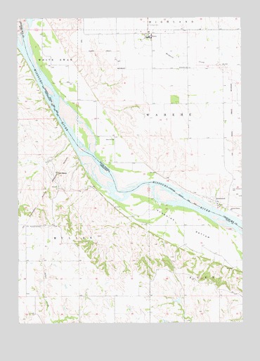
Marty, SD USGS Topographic Map
Click on map above to begin viewing in our Map Viewer.

This topographic map contains these locations and features:
Feature Name Type Latitude Longitude GNIS ID View Map
GreenwoodPopulated PlaceN42.9231°W98.3884°1265646View Map
Greenwood Episcopal CemeteryCemeteryN42.9256°W98.3818°2773603View Map
Greenwood Presbyterian CemeteryCemeteryN42.9318°W98.3790°2773604View Map
Holy Fellowship CemeteryCemeteryN42.9308°W98.3792°1255628View Map
MartyPopulated PlaceN42.9925°W98.4251°1256340View Map
Marty Census Designated PlaceCensusN42.9965°W98.4302°2393121View Map
Marty Elementary SchoolSchoolN42.9943°W98.4248°2728940View Map
Marty Indian SchoolSchoolN42.9943°W98.4248°1264779View Map
Marty Middle SchoolSchoolN42.9943°W98.4248°2728941View Map
Marty Post Office (historical)Post OfficeN42.9919°W98.4266°2710568View Map
Micanek ReservoirLakeN42.8839°W98.4119°1769221View Map
Michanek DamDamN42.8830°W98.4109°1769220View Map
Old BaldySummitN42.9369°W98.4779°831843View Map
Saint Pauls CemeteryCemeteryN42.9969°W98.4265°1257720View Map
School Number 81SchoolN42.9792°W98.4054°1257972View Map
School Number 82SchoolN42.9500°W98.4465°1257974View Map
School Number 83SchoolN42.9211°W98.3812°1257976View Map
Sevenmile CreekStreamN42.9992°W98.4915°1258022View Map
Sunshine BottomBendN42.9142°W98.4076°833949View Map
Township of MullenCivilN42.9244°W98.4954°838149View Map
Township of WaheheCivilN42.9585°W98.4019°1268931View Map

Note: Coordinates in the location and feature list above are referenced to NAD83 datum.


Copyright (C) 2008-2025 Ryan Niemi / Sunset Dynamics ... All Rights Reserved