TopoQuest Logo
Do you find TopoQuest useful?
Help keep TopoQuest running and adding new maps/features by donating!
Bitcoin:  19c7KJd3qBynnjoSw5npx9KScwjBe4ifkT
Litecoin:  LXs6TkuXGGXo1vDsWCkWVdjQX94eUKd6ui
Home View Maps Find Maps Find Places Resources & Links


Matador, Texas Topographic Map

USGS Map Title: Matador, TX
USGS Map MRC: 34100A7
DRG (GeoTIFF) Download: o34100a7.tif


Neighboring USGS Topographic Map Quads:


  Flomot, TX  
34100B8
 

  Hornica Creek, TX  
34100B7
 

  Turtle Hole Camp, TX  
34100B6
 

  Whiteflat, TX  
34100A8
 

  Matador, TX  
34100A7
 

  Ballard Camp, TX  
34100A6
 

  Mac Bain, TX  
33100H8
 

  Roaring Springs, TX  
33100H7
 

  Russellville, TX  
33100H6


Map MRC Location:

N35°
W101°
N35°
W100°
H8 H7 H6 H5 H4 H3 H2 H1
G8 G7 G6 G5 G4 G3 G2 G1
F8 F7 F6 F5 F4 F3 F2 F1
E8 E7 E6 E5 E4 E3 E2 E1
D8 D7 D6 D5 D4 D3 D2 D1
C8 C7 C6 C5 C4 C3 C2 C1
B8 B7 B6 B5 B4 B3 B2 B1
A8 A7 A6 A5 A4 A3 A2 A1
N34°
W101°
N34°
W100°

Matador, TX USGS 1:24K Topographic Map Preview:
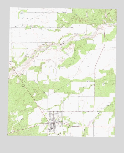
Matador, TX USGS Topographic Map
Click on map above to begin viewing in our Map Viewer.

This topographic map contains these locations and features:
Feature Name Type Latitude Longitude GNIS ID View Map
East Mound CemeteryCemeteryN34.0140°W100.8052°1356671View Map
Ed Jameson LakeReservoirN34.0166°W100.7755°1861780View Map
Ed Jameson Lake DamDamN34.0167°W100.7754°1861779View Map
Hackberry DrawValleyN34.0015°W100.8482°1358587View Map
MatadorPopulated PlaceN34.0120°W100.8221°1362272View Map
Matador City HallBuildingN34.0131°W100.8212°2753290View Map
Matador Post OfficePost OfficeN34.0130°W100.8215°2731453View Map
Matador Volunteer Fire DepartmentBuildingN34.0136°W100.8205°2552090View Map
McDonald CreekStreamN34.0104°W100.7837°1362426View Map
Motley CountyCivilN34.0741°W100.7798°1383958View Map
Motley County Ambulance ServiceBuildingN34.0136°W100.8205°2551293View Map
Motley County Historical MuseumBuildingN34.1220°W100.7749°2014500View Map
Motley County JailBuildingN34.0139°W100.8215°2738823View Map
Motley County Jail MuseumBuildingN34.0145°W100.8226°2032352View Map
Motley County Sheriff's OfficeBuildingN34.0139°W100.8214°2750423View Map
Town of MatadorCivilN34.0151°W100.8211°2412962View Map
Traweek HouseBuildingN34.0112°W100.8249°2032527View Map

Note: Coordinates in the location and feature list above are referenced to NAD83 datum.


Copyright (C) 2008-2024 Ryan Niemi / Sunset Dynamics ... All Rights Reserved