TopoQuest Logo
Do you find TopoQuest useful?
Help keep TopoQuest running and adding new maps/features by donating!
Bitcoin:  19c7KJd3qBynnjoSw5npx9KScwjBe4ifkT
Litecoin:  LXs6TkuXGGXo1vDsWCkWVdjQX94eUKd6ui
Home View Maps Find Maps Find Places Resources & Links


McClure, Oklahoma Topographic Map

USGS Map Title: McClure, OK
USGS Map MRC: 35099F3
DRG (GeoTIFF) Download: o35099f3.tif


Neighboring USGS Topographic Map Quads:


  Leedey SW, OK  
35099G4
 

  Leedey, OK  
35099G3
 

  Rhea, OK  
35099G2
 

  Hammon, OK  
35099F4
 

  McClure, OK  
35099F3
 

  Butler, OK  
35099F2
 

  Big Kiowa Creek, OK  
35099E4
 

  Carpenter, OK  
35099E3
 

  Foss Dam, OK  
35099E2


Map MRC Location:

N36°
W100°
N36°
W99°
H8 H7 H6 H5 H4 H3 H2 H1
G8 G7 G6 G5 G4 G3 G2 G1
F8 F7 F6 F5 F4 F3 F2 F1
E8 E7 E6 E5 E4 E3 E2 E1
D8 D7 D6 D5 D4 D3 D2 D1
C8 C7 C6 C5 C4 C3 C2 C1
B8 B7 B6 B5 B4 B3 B2 B1
A8 A7 A6 A5 A4 A3 A2 A1
N35°
W100°
N35°
W99°

McClure, OK USGS 1:24K Topographic Map Preview:
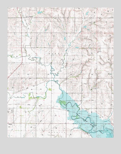
McClure, OK USGS Topographic Map
Click on map above to begin viewing in our Map Viewer.

This topographic map contains these locations and features:
Feature Name Type Latitude Longitude GNIS ID View Map
Bethel CemeteryCemeteryN35.6506°W99.3685°1777595View Map
Butler DivisionCivilN35.6454°W99.2606°1937657View Map
McClurePopulated PlaceN35.6514°W99.3057°1100614View Map
MoorewoodPopulated PlaceN35.7403°W99.3490°1100643View Map
Moorewood CemeteryCemeteryN35.7469°W99.3556°2709396View Map
North Branch Quartermaster CreekStreamN35.7034°W99.3509°1095922View Map
Oknoname 039001 DamDamN35.7284°W99.2820°1755462View Map
Oknoname 039001 ReservoirReservoirN35.7284°W99.2820°1755463View Map
Quartermaster CreekStreamN35.6792°W99.3165°1101609View Map
Quartermaster Creek Site 28 DamDamN35.7167°W99.3054°1758486View Map
Quartermaster Creek Site 28 ReservoirReservoirN35.7167°W99.3054°1758487View Map
Quartermaster Creek Site 29 DamDamN35.7100°W99.2987°1758484View Map
Quartermaster Creek Site 29 ReservoirReservoirN35.7100°W99.2987°1758485View Map
Quartermaster Creek Site 30 DamDamN35.7317°W99.2854°1758482View Map
Quartermaster Creek Site 30 ReservoirReservoirN35.7317°W99.2854°1758483View Map
Quartermaster Site 25 DamDamN35.7450°W99.3354°1758492View Map
Quartermaster Site 25 ReservoirReservoirN35.7450°W99.3354°1758493View Map
Quartermaster Site 27 DamDamN35.7434°W99.2837°1758488View Map
Quartermaster Site 27 ReservoirReservoirN35.7434°W99.2837°1758489View Map
White Shield CreekStreamN35.6634°W99.3698°1099717View Map
Wild Horse CreekStreamN35.6845°W99.3187°1099759View Map

Note: Coordinates in the location and feature list above are referenced to NAD83 datum.


Copyright (C) 2008-2024 Ryan Niemi / Sunset Dynamics ... All Rights Reserved