TopoQuest Logo
Do you find TopoQuest useful?
Help keep TopoQuest running and adding new maps/features by donating!
Bitcoin:  19c7KJd3qBynnjoSw5npx9KScwjBe4ifkT
Litecoin:  LXs6TkuXGGXo1vDsWCkWVdjQX94eUKd6ui
Home View Maps Find Maps Find Places Resources & Links


McIntosh, Florida Topographic Map

USGS Map Title: McIntosh, FL
USGS Map MRC: 29082D2
DRG (GeoTIFF) Download: o29082d2.tif


Neighboring USGS Topographic Map Quads:


  Micanopy, FL  
29082E3
 

  Rochelle, FL  
29082E2
 

  Hawthorne, FL  
29082E1
 

  Flemington, FL  
29082D3
 

  McIntosh, FL  
29082D2
 

  Citra, FL  
29082D1
 

  Fairfield, FL  
29082C3
 

  Reddick, FL  
29082C2
 

  Anthony, FL  
29082C1


Map MRC Location:

N30°
W83°
N30°
W82°
H8 H7 H6 H5 H4 H3 H2 H1
G8 G7 G6 G5 G4 G3 G2 G1
F8 F7 F6 F5 F4 F3 F2 F1
E8 E7 E6 E5 E4 E3 E2 E1
D8 D7 D6 D5 D4 D3 D2 D1
C8 C7 C6 C5 C4 C3 C2 C1
B8 B7 B6 B5 B4 B3 B2 B1
A8 A7 A6 A5 A4 A3 A2 A1
N29°
W83°
N29°
W82°

McIntosh, FL USGS 1:24K Topographic Map Preview:
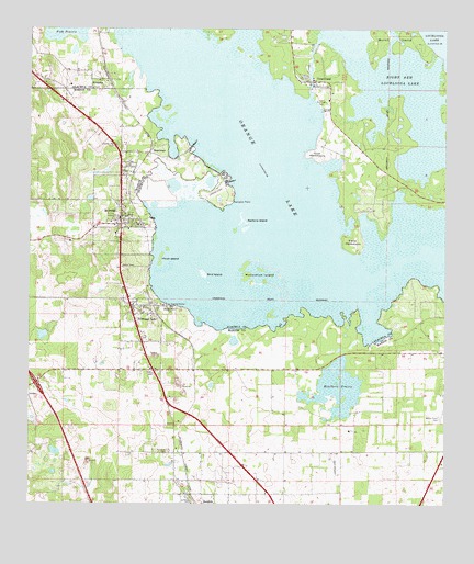
McIntosh, FL USGS Topographic Map
Click on map above to begin viewing in our Map Viewer.

This topographic map contains these locations and features:
Feature Name Type Latitude Longitude GNIS ID View Map
Alachua County Fire Rescue Station 31BuildingN29.4781°W82.1592°2047296View Map
Bird IslandIslandN29.4355°W82.1973°278800View Map
BoardmanPopulated PlaceN29.4675°W82.2140°295143View Map
Burnt IslandIslandN29.4989°W82.1379°279711View Map
Cane HammockIslandN29.4452°W82.1520°279970View Map
Center Hill CemeteryCemeteryN29.4700°W82.2237°280237View Map
Center Point CemeteryCemeteryN29.4699°W82.2236°2040051View Map
Clay Electric Cooperative SubstationBuildingN29.4291°W82.2262°2053404View Map
Community Presbyterian ChurchChurchN29.4422°W82.2229°2053402View Map
Cow HammockIslandN29.4664°W82.1637°280929View Map
Cross CreekChannelN29.4911°W82.1654°281092View Map
Cross CreekPopulated PlaceN29.4864°W82.1651°281093View Map
Cross Creek Baptist ChurchChurchN29.4783°W82.1587°2047295View Map
DungarvinLocaleN29.4294°W82.2473°303909View Map
Emmanuel Apostolic Overcoming Holiness Church of GodChurchN29.3800°W82.1283°2448319View Map
EvinstonPopulated PlaceN29.4869°W82.2312°282322View Map
Evinston Post OfficePost OfficeN29.4853°W82.2258°2047297View Map
Evinston United Methodist ChurchChurchN29.4866°W82.2282°2047298View Map
FAA Radio Tower (ASR-9)TowerN29.4097°W82.2120°2053414View Map
First Baptist Church of McIntoshChurchN29.4497°W82.2223°2053401View Map
George I F Clark GrantCivilN29.4239°W82.1320°303908View Map
Hawthorn PrairieSwampN29.4060°W82.1569°283828View Map
Heagy Burry ParkParkN29.4266°W82.2073°283851View Map
Hixon IslandIslandN29.4397°W82.2104°284053View Map
Lakeside Travel ParkPopulated PlaceN29.4170°W82.1437°2448002View Map
Marion County Fire Rescue Station 9 LakesideBuildingN29.4242°W82.2175°2053409View Map
Marion County Sheriff's OfficeBuildingN29.4243°W82.2179°2333114View Map
Marjorie Kinnan Rawlings Historic State ParkParkN29.4805°W82.1615°289516View Map
Marjorie Kinnan Rawlings House and Farm YardParkN29.4556°W82.1300°2561262View Map
McCormick IslandIslandN29.4350°W82.1843°286586View Map
McIntoshPopulated PlaceN29.4489°W82.2220°286619View Map
McIntosh Christian ChurchChurchN29.4514°W82.2195°2053397View Map
McIntosh Post OfficePost OfficeN29.4486°W82.2171°2053399View Map
McIntosh Presbyterian ChurchChurchN29.4502°W82.2198°2053398View Map
McIntosh United Methodist ChurchChurchN29.4497°W82.2212°2053400View Map
MillwoodPopulated PlaceN29.3814°W82.2045°303905View Map
Millwood CemeteryCemeteryN29.3889°W82.2076°286945View Map
Mount Ella Missionary Baptist ChurchChurchN29.4711°W82.2226°2053395View Map
Mount Olive AME ChurchChurchN29.4847°W82.2309°2047299View Map
Mount Sinai Baptist ChurchChurchN29.4108°W82.2179°2053413View Map
New Life Tabernacle of DeliveranceChurchN29.3791°W82.2032°2053415View Map
Orange LakePopulated PlaceN29.4236°W82.2168°288215View Map
Orange LakeLakeN29.4596°W82.1831°288216View Map
Orange Lake Baptist ChurchChurchN29.4261°W82.2129°2053410View Map
Orange Lake Post OfficePost OfficeN29.4288°W82.2205°2053403View Map
Paynes Town (historical)Populated PlaceN29.4169°W82.2332°294521View Map
Redbird IslandIslandN29.4500°W82.1857°289558View Map
Right Arm Lochloosa LakeLakeN29.4801°W82.1366°289698View Map
Rimes Lakecrest AirportAirportN29.4691°W82.1606°2676655View Map
Sneed Chapel AME ChurchChurchN29.4144°W82.2148°2053412View Map
Solomon Chapel United Methodist ChurchChurchN29.4175°W82.2220°2053411View Map
Thomas Clark GrantCivilN29.4155°W82.1929°303910View Map
Thompson's Goinbroke Aero Ranch AirportAirportN29.3861°W82.1436°2574806View Map
Town of McIntoshCivilN29.4493°W82.2210°2406132View Map
Willow Plant CemeteryCemeteryN29.3980°W82.1262°293358View Map
Zion Bethel Baptist ChurchChurchN29.4555°W82.2218°2053396View Map

Note: Coordinates in the location and feature list above are referenced to NAD83 datum.


Copyright (C) 2008-2025 Ryan Niemi / Sunset Dynamics ... All Rights Reserved