TopoQuest Logo
Do you find TopoQuest useful?
Help keep TopoQuest running and adding new maps/features by donating!
Bitcoin:  19c7KJd3qBynnjoSw5npx9KScwjBe4ifkT
Litecoin:  LXs6TkuXGGXo1vDsWCkWVdjQX94eUKd6ui
Home View Maps Find Maps Find Places Resources & Links


Meadow, Tennessee Topographic Map

USGS Map Title: Meadow, TN
USGS Map MRC: 35084F2
DRG (GeoTIFF) Download: o35084f2.tif


Neighboring USGS Topographic Map Quads:


  Lenoir City, TN  
35084G3
 

  Concord, TN  
35084G2
 

  Louisville, TN  
35084G1
 

  Loudon, TN  
35084F3
 

  Meadow, TN  
35084F2
 

  Binfield, TN  
35084F1
 

  Madisonville, TN  
35084E3
 

  Vonore, TN  
35084E2
 

  Tallassee, TN  
35084E1


Map MRC Location:

N36°
W85°
N36°
W84°
H8 H7 H6 H5 H4 H3 H2 H1
G8 G7 G6 G5 G4 G3 G2 G1
F8 F7 F6 F5 F4 F3 F2 F1
E8 E7 E6 E5 E4 E3 E2 E1
D8 D7 D6 D5 D4 D3 D2 D1
C8 C7 C6 C5 C4 C3 C2 C1
B8 B7 B6 B5 B4 B3 B2 B1
A8 A7 A6 A5 A4 A3 A2 A1
N35°
W85°
N35°
W84°

Meadow, TN USGS 1:24K Topographic Map Preview:
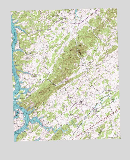
Meadow, TN USGS Topographic Map
Click on map above to begin viewing in our Map Viewer.

This topographic map contains these locations and features:
Feature Name Type Latitude Longitude GNIS ID View Map
Alexander KnobSummitN35.7104°W84.1794°1275561View Map
Alexander QuarryMineN35.7059°W84.1821°1643275View Map
Alleghany (historical)Populated PlaceN35.6651°W84.1982°1309510View Map
Andies QuarryMineN35.7004°W84.1885°1643250View Map
Axley CemeteryCemeteryN35.7094°W84.2302°1276020View Map
Axley ChapelChurchN35.7045°W84.2319°1304904View Map
Baker CreekStreamN35.6454°W84.2319°1304929View Map
Bellview ChurchChurchN35.6804°W84.2221°1305097View Map
Bellview School (historical)SchoolN35.6806°W84.2221°1309617View Map
Big HillSummitN35.6517°W84.2255°1277304View Map
Blankenship CemeteryCemeteryN35.6662°W84.2419°1277663View Map
Blankenship SpringSpringN35.6406°W84.2171°1309512View Map
Bream Hole DamDamN35.6823°W84.1871°1302040View Map
Bream Hole LakeReservoirN35.6827°W84.1866°1302043View Map
Buzzards Roost QuarryMineN35.7101°W84.1513°1642553View Map
Byrd BranchStreamN35.6387°W84.1724°1279245View Map
Carpenters Island (historical)IslandN35.6876°W84.2458°1643266View Map
Carpenters ShoalsBarN35.6867°W84.2460°1643267View Map
CentersvillePopulated PlaceN35.7145°W84.2074°1280151View Map
Chapel HIllSummitN35.7009°W84.2371°1309529View Map
City of GreenbackCivilN35.6491°W84.1724°2403739View Map
Cloyd Creek (historical)Populated PlaceN35.6987°W84.1388°1308059View Map
Cloyds Creek CemeteryCemeteryN35.6981°W84.1605°1642459View Map
Cloyds Creek Presbyterian ChurchChurchN35.6979°W84.1596°1305995View Map
Commissioner District 3CivilN35.6944°W84.2044°2464170View Map
Coyatee Ford (historical)CrossingN35.7151°W84.2485°1643265View Map
Coytee (historical)Populated PlaceN35.7142°W84.2394°1326876View Map
Coytee FarmsLocaleN35.7222°W84.2189°2652505View Map
Coytee School (historical)SchoolN35.7140°W84.2396°1309619View Map
Coytee SpringSpringN35.7151°W84.2466°1281516View Map
Craig ChapelChurchN35.6495°W84.1730°1281543View Map
Craig QuarryMineN35.7404°W84.1469°1642556View Map
Craigmar (historical)Populated PlaceN35.7395°W84.1694°1642559View Map
Crisp QuarryMineN35.7287°W84.1549°1642555View Map
Davis FerryCrossingN35.7301°W84.2469°1306285View Map
Davis IslandIslandN35.6326°W84.2496°1282192View Map
Davis ShoalsBarN35.7281°W84.2458°1643272View Map
Douthit CemeteryCemeteryN35.7212°W84.2424°1282751View Map
Dunlap HollowValleyN35.7456°W84.1507°1642557View Map
Dunlap Hollow CreekStreamN35.7395°W84.1682°1642558View Map
Floyd CreekStreamN35.7445°W84.1724°1284524View Map
GlendalePopulated PlaceN35.7312°W84.2071°1285506View Map
Glendale School (historical)SchoolN35.7145°W84.2088°1309534View Map
GreenbackPopulated PlaceN35.6612°W84.1721°1286135View Map
Greenback Division (historical)CensusN35.6834°W84.1982°1648835View Map
Greenback Fire and Rescue Station 1BuildingN35.6585°W84.1776°2654404View Map
Greenback Fire and Rescue Station 2BuildingN35.6362°W84.1581°2654524View Map
Greenback High SchoolSchoolN35.6592°W84.1741°1309537View Map
Greenback Post OfficePost OfficeN35.6613°W84.1714°1649966View Map
Griffitts (historical)Populated PlaceN35.6820°W84.2305°1309536View Map
Gulf SpringSpringN35.7082°W84.1348°1286386View Map
Hackney Chapel African Methodist Episcopal Zion ChurchChurchN35.7448°W84.1969°1286479View Map
Hammontree LakeReservoirN35.6832°W84.1837°1302041View Map
Hammontree Lake DamDamN35.6831°W84.1839°1302042View Map
Hickory ValleyValleyN35.7399°W84.1749°1287629View Map
Hickory Valley ChurchChurchN35.7409°W84.1891°1287631View Map
Jackson CemeteryCemeteryN35.6803°W84.2410°1289197View Map
Jackson Ferry (historical)CrossingN35.6795°W84.2430°1309549View Map
JenaPopulated PlaceN35.6548°W84.1557°1289340View Map
KiserPopulated PlaceN35.7412°W84.1666°1315334View Map
Kiser ChapelChurchN35.6962°W84.1580°1290313View Map
Liberty CemeteryCemeteryN35.6262°W84.1335°1642551View Map
Liberty ChurchChurchN35.6265°W84.1344°1291125View Map
Lotterdale Cove Recreation AreaParkN35.6767°W84.2385°1322673View Map
Lotterdale KnobSummitN35.6701°W84.2177°1292096View Map
Lower Morganton ShoalsBarN35.6542°W84.2369°1643286View Map
Marble HillPopulated PlaceN35.7184°W84.1405°1292662View Map
Marble Hill School (historical)SchoolN35.7192°W84.1410°1310111View Map
Marthens QuarryMineN35.7098°W84.1524°1642552View Map
McDonald CemeteryCemeteryN35.7156°W84.2344°1309572View Map
McKelvey CemeteryCemeteryN35.7055°W84.2389°1293349View Map
McMullen QuarryMineN35.7162°W84.1638°1642554View Map
McMullensPopulated PlaceN35.7165°W84.1727°1315491View Map
MeadowPopulated PlaceN35.6976°W84.1644°1293482View Map
MorgantonPopulated PlaceN35.6434°W84.2271°1294384View Map
Morganton Baptist ChurchChurchN35.6387°W84.2163°1643298View Map
Morganton CemeteryCemeteryN35.6426°W84.2235°1309574View Map
Morganton Cumberland Presbyterian Church (historical)ChurchN35.6437°W84.2257°1643300View Map
Morganton FerryCrossingN35.6415°W84.2332°1294385View Map
Morganton Recreation AreaParkN35.6395°W84.2185°1309573View Map
National Camp GroundLocaleN35.6854°W84.2230°1295255View Map
Negro HollowValleyN35.6515°W84.2316°1295338View Map
Niles Ferry ChurchChurchN35.6354°W84.1613°1295758View Map
Owl HollowValleyN35.6976°W84.2470°1309586View Map
Palin (historical)Populated PlaceN35.6792°W84.2496°1309588View Map
Pine Grove ChurchChurchN35.6520°W84.1541°1297528View Map
Pope's Plant FarmLocaleN35.6383°W84.1639°2652571View Map
Red KnobsSummitN35.6909°W84.1902°1299072View Map
Rollen SpringSpringN35.6490°W84.1802°1300027View Map
Rollins CemeteryCemeteryN35.6320°W84.2035°1309600View Map
Sinking CreekStreamN35.6990°W84.2496°1270377View Map
Sinking Creek ChurchChurchN35.6745°W84.1907°1270390View Map
Smith CemeteryCemeteryN35.6517°W84.2413°1270608View Map
Tipton CemeteryCemeteryN35.6395°W84.2410°1272681View Map
UnitiaPopulated PlaceN35.7467°W84.1796°1314437View Map
Unitia CemeteryCemeteryN35.7492°W84.1749°1309627View Map
Unitia Methodist ChurchChurchN35.7473°W84.1805°1643322View Map
Unitia Presbyterian ChurchChurchN35.7492°W84.1749°1643321View Map
Unitia School (historical)SchoolN35.7445°W84.2052°1309628View Map
Upper Morganton ShoalsBarN35.6356°W84.2433°1643323View Map
Village AirportAirportN35.6556°W84.1855°2675558View Map

Note: Coordinates in the location and feature list above are referenced to NAD83 datum.


Copyright (C) 2008-2024 Ryan Niemi / Sunset Dynamics ... All Rights Reserved