TopoQuest Logo
Do you find TopoQuest useful?
Help keep TopoQuest running and adding new maps/features by donating!
Bitcoin:  19c7KJd3qBynnjoSw5npx9KScwjBe4ifkT
Litecoin:  LXs6TkuXGGXo1vDsWCkWVdjQX94eUKd6ui
Home View Maps Find Maps Find Places Resources & Links


Meadville, Missouri Topographic Map

USGS Map Title: Meadville, MO
USGS Map MRC: 39093G3
DRG (GeoTIFF) Download: o39093g3.tif


Neighboring USGS Topographic Map Quads:


  Chula, MO  
39093H4
 

  Eversonville, MO  
39093H3
 

  Linneus, MO  
39093H2
 

  Wheeling, MO  
39093G4
 

  Meadville, MO  
39093G3
 

  Laclede, MO  
39093G2
 

  Avalon, MO  
39093F4
 

  Fountain Grove, MO  
39093F3
 

  Sumner, MO  
39093F2


Map MRC Location:

N40°
W94°
N40°
W93°
H8 H7 H6 H5 H4 H3 H2 H1
G8 G7 G6 G5 G4 G3 G2 G1
F8 F7 F6 F5 F4 F3 F2 F1
E8 E7 E6 E5 E4 E3 E2 E1
D8 D7 D6 D5 D4 D3 D2 D1
C8 C7 C6 C5 C4 C3 C2 C1
B8 B7 B6 B5 B4 B3 B2 B1
A8 A7 A6 A5 A4 A3 A2 A1
N39°
W94°
N39°
W93°

Meadville, MO USGS 1:24K Topographic Map Preview:
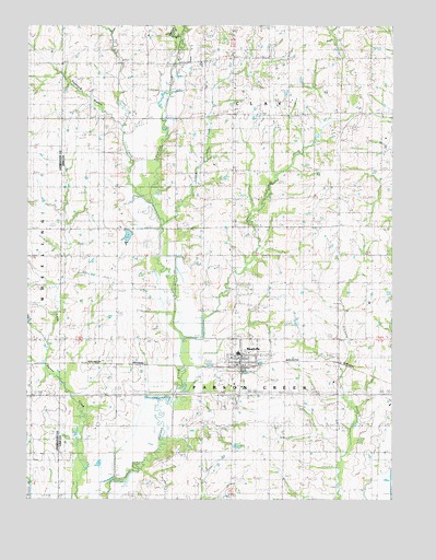
Meadville, MO USGS Topographic Map
Click on map above to begin viewing in our Map Viewer.

This topographic map contains these locations and features:
Feature Name Type Latitude Longitude GNIS ID View Map
Belcher SchoolSchoolN39.7770°W93.3449°713887View Map
Bethel CemeteryCemeteryN39.7731°W93.2730°714034View Map
Bethel SchoolSchoolN39.7709°W93.2688°714084View Map
Botts CemeteryCemeteryN39.8361°W93.3038°714554View Map
Botts School (historical)SchoolN39.8292°W93.3044°714555View Map
Centerview SchoolSchoolN39.8067°W93.2691°715668View Map
City of MeadvilleCivilN39.7881°W93.2992°2395078View Map
Coon CreekStreamN39.8286°W93.3344°716258View Map
Duncan SchoolSchoolN39.8659°W93.3038°717183View Map
East Point SchoolSchoolN39.8378°W93.2680°717336View Map
Eureka ChurchChurchN39.8647°W93.3383°717653View Map
Eureka School (historical)SchoolN39.8581°W93.3527°717659View Map
Fairview SchoolSchoolN39.8664°W93.2577°717814View Map
Lewis CreekStreamN39.7936°W93.3227°720940View Map
Lousy CreekStreamN39.8228°W93.3283°738438View Map
LowellPopulated PlaceN39.8514°W93.3547°740195View Map
Lowell Post OfficePost OfficeN39.8514°W93.3547°759952View Map
MeadvillePopulated PlaceN39.7842°W93.3022°735719View Map
Meadville CemeteryCemeteryN39.7928°W93.3044°2702413View Map
Meadville Community Fire DepartmentBuildingN39.7854°W93.3023°2621434View Map
Meadville Post OfficePost OfficeN39.7864°W93.3023°2782975View Map
Meadville Rural Fire AssociationBuildingN39.7855°W93.3023°2620989View Map
Patterson BranchStreamN39.8475°W93.3430°724081View Map
Pleasant Point ChurchChurchN39.8514°W93.2852°724573View Map
Pleasant Valley School (historical)SchoolN39.8136°W93.3433°735793View Map
Smoky CreekStreamN39.8747°W93.3241°726644View Map
Township of ClayCivilN39.8733°W93.2960°766916View Map
Township of Parson CreekCivilN39.7630°W93.2982°766924View Map

Note: Coordinates in the location and feature list above are referenced to NAD83 datum.


Copyright (C) 2008-2025 Ryan Niemi / Sunset Dynamics ... All Rights Reserved