TopoQuest Logo
Do you find TopoQuest useful?
Help keep TopoQuest running and adding new maps/features by donating!
Bitcoin:  19c7KJd3qBynnjoSw5npx9KScwjBe4ifkT
Litecoin:  LXs6TkuXGGXo1vDsWCkWVdjQX94eUKd6ui
Home View Maps Find Maps Find Places Resources & Links


Medical Lake, Washington Topographic Map

USGS Map Title: Medical Lake, WA
USGS Map MRC: 47117E6
DRG (GeoTIFF) Download: o47117e6.tif


Neighboring USGS Topographic Map Quads:


  Reardan East, WA  
47117F7
 

  Deep Creek, WA  
47117F6
 

  Airway Heights, WA  
47117F5
 

  Waukon, WA  
47117E7
 

  Medical Lake, WA  
47117E6
 

  Four Lakes, WA  
47117E5
 

  Tyler, WA  
47117D7
 

  Lance Hills, WA  
47117D6
 

  Cheney, WA  
47117D5


Map MRC Location:

N48°
W118°
N48°
W117°
H8 H7 H6 H5 H4 H3 H2 H1
G8 G7 G6 G5 G4 G3 G2 G1
F8 F7 F6 F5 F4 F3 F2 F1
E8 E7 E6 E5 E4 E3 E2 E1
D8 D7 D6 D5 D4 D3 D2 D1
C8 C7 C6 C5 C4 C3 C2 C1
B8 B7 B6 B5 B4 B3 B2 B1
A8 A7 A6 A5 A4 A3 A2 A1
N47°
W118°
N47°
W117°

Medical Lake, WA USGS 1:24K Topographic Map Preview:
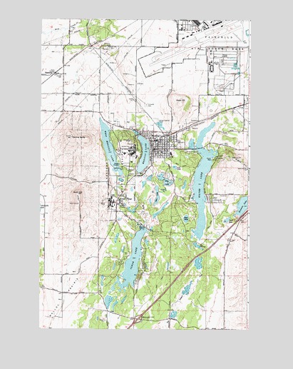
Medical Lake, WA USGS Topographic Map
Click on map above to begin viewing in our Map Viewer.

This topographic map contains these locations and features:
Feature Name Type Latitude Longitude GNIS ID View Map
American Medical ResponseBuildingN47.5685°W117.6788°2643771View Map
Big SwampSwampN47.5339°W117.6562°1503364View Map
Booth HillSummitN47.5546°W117.7274°1503480View Map
Cheney-Medical Lake DivisionCivilN47.5366°W117.6925°1939560View Map
City of Medical LakeCivilN47.5712°W117.6896°2411070View Map
Clear LakeLakeN47.5275°W117.6945°1504010View Map
Duck LakeLakeN47.5442°W117.6385°1504579View Map
Eastern State HospitalHospitalN47.5737°W117.7046°1504662View Map
EspanolaPopulated PlaceN47.6032°W117.7416°1510948View Map
Fairchild Air Force BaseAirportN47.6185°W117.6558°2443324View Map
Fairchild Air Force BaseMilitaryN47.6241°W117.6579°2512178View Map
Fairchild Air Force Base Census Designated PlaceCensusN47.6186°W117.6485°2408102View Map
Fairchild Air Force Base Fire DepartmentBuildingN47.6201°W117.6579°2643965View Map
Fancher ButteSummitN47.5774°W117.7313°1504797View Map
Flying R Ranch AirportAirportN47.5029°W117.6477°2443365View Map
Granite LakeLakeN47.5506°W117.6282°1505222View Map
Interlake SchoolSchoolN47.5707°W117.6949°1514836View Map
Lakeland VillagePopulated PlaceN47.5510°W117.7049°1512370View Map
Lakes Memorial CemeteryCemeteryN47.5652°W117.6993°1506061View Map
Malloy PrairieFlatN47.5124°W117.7349°1506440View Map
Medical LakePopulated PlaceN47.5729°W117.6822°1512452View Map
Medical LakeLakeN47.5704°W117.6884°1506606View Map
Medical Lake CemeteryCemeteryN47.6135°W117.7080°1506607View Map
Medical Lake Cheney InterchangeCrossingN47.5041°W117.6908°1506608View Map
Medical Lake Elementary SchoolSchoolN47.5699°W117.6710°1514835View Map
Medical Lake Elementary SchoolSchoolN47.5699°W117.6710°1514846View Map
Medical Lake Fire DepartmentBuildingN47.5720°W117.6830°2619431View Map
Medical Lake High SchoolSchoolN47.5763°W117.6811°1514834View Map
Medical Lake Middle SchoolSchoolN47.5720°W117.6700°1514837View Map
Medical Lake Police DepartmentBuildingN47.5722°W117.6829°2721893View Map
Medical Lake Post OfficePost OfficeN47.5717°W117.6789°2781668View Map
Medical Lake Waterfront ParkParkN47.5627°W117.6905°1506610View Map
Olson HillSummitN47.5918°W117.6660°1507176View Map
Otter LakeLakeN47.5540°W117.6803°1507221View Map
Page PondLakeN47.5446°W117.6628°1507257View Map
Riddle HillSummitN47.5649°W117.6263°1512603View Map
Ring LakeLakeN47.5585°W117.6737°1507811View Map
Saint Annes CemeteryCemeteryN47.5905°W117.6869°1508003View Map
Silver LakeLakeN47.5565°W117.6536°1508345View Map
Silver LakePopulated PlaceN47.5529°W117.6491°1514874View Map
Spokane County Fire District 3 Fairchild Air Force Base Fire DepartmentBuildingN47.6073°W117.6467°2643962View Map
Spokane County Fire District 3 Station 32 - Medical LakeBuildingN47.5265°W117.7255°2643963View Map
Tule PondLakeN47.5655°W117.6697°1509115View Map
West Medical LakeLakeN47.5730°W117.7088°1509415View Map

Note: Coordinates in the location and feature list above are referenced to NAD83 datum.


Copyright (C) 2008-2024 Ryan Niemi / Sunset Dynamics ... All Rights Reserved