TopoQuest Logo
Do you find TopoQuest useful?
Help keep TopoQuest running and adding new maps/features by donating!
Bitcoin:  19c7KJd3qBynnjoSw5npx9KScwjBe4ifkT
Litecoin:  LXs6TkuXGGXo1vDsWCkWVdjQX94eUKd6ui
Home View Maps Find Maps Find Places Resources & Links


Menard, Texas Topographic Map

USGS Map Title: Menard, TX
USGS Map MRC: 30099H7
DRG (GeoTIFF) Download: o30099h7.tif


Neighboring USGS Topographic Map Quads:


  Eden SW, TX  
31099A8
 

  Eden SE, TX  
31099A7
 

  Callan, TX  
31099A6
 

  Clear Creek Lake, TX  
30099H8
 

  Menard, TX  
30099H7
 

  Chapman Draw, TX  
30099H6
 

  San Augustine Draw, TX  
30099G8
 

  Spoon Draw, TX  
30099G7
 

  East Elm Creek, TX  
30099G6


Map MRC Location:

N31°
W100°
N31°
W99°
H8 H7 H6 H5 H4 H3 H2 H1
G8 G7 G6 G5 G4 G3 G2 G1
F8 F7 F6 F5 F4 F3 F2 F1
E8 E7 E6 E5 E4 E3 E2 E1
D8 D7 D6 D5 D4 D3 D2 D1
C8 C7 C6 C5 C4 C3 C2 C1
B8 B7 B6 B5 B4 B3 B2 B1
A8 A7 A6 A5 A4 A3 A2 A1
N30°
W100°
N30°
W99°

Menard, TX USGS 1:24K Topographic Map Preview:
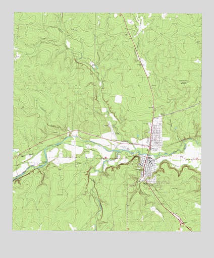
Menard, TX USGS Topographic Map
Click on map above to begin viewing in our Map Viewer.

This topographic map contains these locations and features:
Feature Name Type Latitude Longitude GNIS ID View Map
Arroyo de Juan LorenzoValleyN30.9202°W99.7910°2750014View Map
Bowie SpringSpringN30.9703°W99.8207°1352748View Map
Celery CreekStreamN30.9199°W99.7915°1354173View Map
City of MenardCivilN30.9184°W99.7837°2411076View Map
Coghlan BranchStreamN30.9218°W99.8531°1354734View Map
Fourmile CrossingPopulated PlaceN30.9141°W99.8528°1379796View Map
Harris HollowValleyN30.9087°W99.7861°1358854View Map
Las Moras CreekStreamN30.9213°W99.8020°1360959View Map
Little Racetrack MountainSummitN30.9610°W99.7626°1361437View Map
MenardPopulated PlaceN30.9177°W99.7865°1362610View Map
Menard City HallBuildingN30.9167°W99.7844°2753843View Map
Menard CountyCivilN30.8898°W99.8206°1383949View Map
Menard County AirportAirportN30.9310°W99.8093°1387174View Map
Menard County JailBuildingN30.9152°W99.7835°2738735View Map
Menard County MuseumBuildingN30.8918°W99.8312°2014486View Map
Menard County Sheriff's OfficeBuildingN30.9151°W99.7836°2750400View Map
Menard Elementary SchoolSchoolN30.9142°W99.7845°2007546View Map
Menard Emergency Service AmbulanceBuildingN30.9137°W99.7859°2656129View Map
Menard High SchoolSchoolN30.9132°W99.7906°2007547View Map
Menard Irrigation Company CanalCanalN30.9177°W99.7951°1362612View Map
Menard Middle SchoolSchoolN30.9141°W99.7845°2007548View Map
Menard Post OfficePost OfficeN30.9327°W99.7841°2731522View Map
Menard Volunteer Fire DepartmentBuildingN30.9072°W99.7880°2551921View Map
Mission San SabaParkN30.9230°W99.8028°2029767View Map
Ninemile CreekStreamN30.9288°W99.8356°1363893View Map
Pioneer Rest CemeteryCemeteryN30.9105°W99.7892°1365341View Map
Rest Haven CemeteryCemeteryN30.9368°W99.7840°1366364View Map
San Saba MissionLocaleN30.9227°W99.8020°1367539View Map
Volkmann DrawValleyN30.9261°W99.7620°1370680View Map

Note: Coordinates in the location and feature list above are referenced to NAD83 datum.


Copyright (C) 2008-2025 Ryan Niemi / Sunset Dynamics ... All Rights Reserved