TopoQuest Logo
Do you find TopoQuest useful?
Help keep TopoQuest running and adding new maps/features by donating!
Bitcoin:  19c7KJd3qBynnjoSw5npx9KScwjBe4ifkT
Litecoin:  LXs6TkuXGGXo1vDsWCkWVdjQX94eUKd6ui
Home View Maps Find Maps Find Places Resources & Links


Mendocino, California Topographic Map

USGS Map Title: Mendocino, CA
USGS Map MRC: 39123C7
DRG (GeoTIFF) Download: o39123c7.tif


Neighboring USGS Topographic Map Quads:


  Fort Bragg, CA  
39123D7
 

  Noyo Hill, CA  
39123D6


  Mendocino, CA  
39123C7
 

  Mathison Peak, CA  
39123C6


  Albion, CA  
39123B7
 

  Elk, CA  
39123B6


Map MRC Location:

N40°
W124°
N40°
W123°
H8 H7 H6 H5 H4 H3 H2 H1
G8 G7 G6 G5 G4 G3 G2 G1
F8 F7 F6 F5 F4 F3 F2 F1
E8 E7 E6 E5 E4 E3 E2 E1
D8 D7 D6 D5 D4 D3 D2 D1
C8 C7 C6 C5 C4 C3 C2 C1
B8 B7 B6 B5 B4 B3 B2 B1
A8 A7 A6 A5 A4 A3 A2 A1
N39°
W124°
N39°
W123°

Mendocino, CA USGS 1:24K Topographic Map Preview:
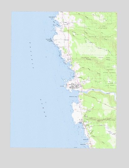
Mendocino, CA USGS Topographic Map
Click on map above to begin viewing in our Map Viewer.

This topographic map contains these locations and features:
Feature Name Type Latitude Longitude GNIS ID View Map
Agate BeachBayN39.3160°W123.8008°218006View Map
Beal CreekStreamN39.2760°W123.7881°218778View Map
Big RiverStreamN39.3021°W123.7947°219234View Map
BlowholeArchN39.3289°W123.8114°2709996View Map
Buckhorn CoveBayN39.2582°W123.7836°220051View Map
Buckhorn CreekStreamN39.2596°W123.7842°220053View Map
Cabrillo PointCapeN39.3493°W123.8283°230848View Map
CasparPopulated PlaceN39.3635°W123.8158°1658232View Map
Caspar AnchorageBayN39.3616°W123.8200°220676View Map
Caspar CemeteryCemeteryN39.3598°W123.8126°2755381View Map
Caspar Census Designated PlaceCensusN39.3631°W123.8042°2628717View Map
Caspar CreekStreamN39.3618°W123.8181°220677View Map
Caspar Headlands State BeachParkN39.3604°W123.8186°1724165View Map
Caspar Headlands State Natural ReserveReserveN39.3606°W123.8245°2570595View Map
Caspar PointCapeN39.3696°W123.8256°220679View Map
Caspar Post Office (historical)Post OfficeN39.3629°W123.8131°1724166View Map
Doyle CreekStreamN39.3604°W123.8189°253689View Map
Evergreen CemeteryCemeteryN39.3066°W123.7949°223298View Map
Fern CanyonValleyN39.2749°W123.7886°223452View Map
Ford House MuseumBuildingN39.3046°W123.8000°1724185View Map
Four Square Light House ChurchChurchN39.3657°W123.8145°1724186View Map
Friendship ParkParkN39.3085°W123.7964°1724188View Map
Goat IslandIslandN39.3066°W123.8128°224244View Map
Hillcrest CemeteryCemeteryN39.3085°W123.7985°225322View Map
Jack Peters GulchValleyN39.3196°W123.8011°226040View Map
Jug Handle State Natural ReserveReserveN39.3743°W123.8053°1723249View Map
JughandleArchN39.3747°W123.8225°2709995View Map
Kelley House MuseumBuildingN39.3052°W123.7992°1724205View Map
KMFB-FM (Mendocino)TowerN39.3424°W123.7820°1662965View Map
KPMO-AM (Mendocino)TowerN39.3424°W123.7820°1662664View Map
Little RiverPopulated PlaceN39.2707°W123.7883°1658981View Map
Little RiverStreamN39.2741°W123.7914°227343View Map
Little River AirportAirportN39.2629°W123.7527°1653607View Map
Little River CemeteryCemeteryN39.2682°W123.7869°227345View Map
Little River Census Designated PlaceCensusN39.2703°W123.7818°2628752View Map
Little River Golf CourseLocaleN39.2721°W123.7789°1654310View Map
Little River Post OfficePost OfficeN39.2708°W123.7890°2760063View Map
MendocinoPopulated PlaceN39.3077°W123.7995°1659106View Map
Mendocino Alternative SchoolSchoolN39.3085°W123.7999°2516064View Map
Mendocino and Headlands Historic DistrictParkN39.3060°W123.8006°1724216View Map
Mendocino Art CenterBuildingN39.3068°W123.8033°1724217View Map
Mendocino Baptist ChurchChurchN39.3066°W123.8020°1724218View Map
Mendocino BayBayN39.2960°W123.8020°228497View Map
Mendocino Census Designated PlaceCensusN39.3107°W123.8263°2408815View Map
Mendocino Community High SchoolSchoolN39.3078°W123.8026°2516048View Map
Mendocino Community LibraryBuildingN39.3063°W123.8033°1724220View Map
Mendocino Headlands State ParkParkN39.3085°W123.8086°1724228View Map
Mendocino High SchoolSchoolN39.3081°W123.8015°236820View Map
Mendocino K - 8 SchoolSchoolN39.3110°W123.7839°2516043View Map
Mendocino Middle SchoolSchoolN39.3116°W123.7845°2516065View Map
Mendocino Post OfficePost OfficeN39.3062°W123.8004°1724229View Map
Mendocino Presbyterian ChurchChurchN39.3049°W123.7967°1724230View Map
Mendocino Sunrise High SchoolSchoolN39.3082°W123.8014°2516032View Map
Mendocino Volunteer Fire Department Station 840BuildingN39.3107°W123.7947°2622214View Map
Mendocino Volunteer Fire Department Station 841BuildingN39.3060°W123.7982°2622213View Map
Pacific OceanSeaN39.3103°W123.8447°247074View Map
Pine GrovePopulated PlaceN39.3493°W123.8142°230693View Map
Point Cabrillo Light StationLocaleN39.3485°W123.8272°1654385View Map
Point Cabrillo Light Station State Historic ParkParkN39.3501°W123.8126°2570924View Map
Russian GulchValleyN39.3291°W123.8058°232050View Map
Russian Gulch State ParkParkN39.3330°W123.7750°232051View Map
Saint Anthony Catholic ChurchChurchN39.3088°W123.7997°1724248View Map
Schoolhouse CreekStreamN39.2613°W123.7870°232674View Map
Slaughterhouse GulchValleyN39.3152°W123.8006°233259View Map
Stillwell PointCapeN39.2535°W123.7858°235485View Map
Temple of Kwan TiChurchN39.3049°W123.8031°1724257View Map
Van Damme BeachBayN39.2730°W123.7914°237001View Map
Van Damme State ParkParkN39.2763°W123.7745°1662318View Map

Note: Coordinates in the location and feature list above are referenced to NAD83 datum.


Copyright (C) 2008-2024 Ryan Niemi / Sunset Dynamics ... All Rights Reserved