TopoQuest Logo
Do you find TopoQuest useful?
Help keep TopoQuest running and adding new maps/features by donating!
Bitcoin:  19c7KJd3qBynnjoSw5npx9KScwjBe4ifkT
Litecoin:  LXs6TkuXGGXo1vDsWCkWVdjQX94eUKd6ui
Home View Maps Find Maps Find Places Resources & Links


Meredosia, Illinois Topographic Map

USGS Map Title: Meredosia, IL
USGS Map MRC: 39090G5
DRG (GeoTIFF) Download: o39090g5.tif


Neighboring USGS Topographic Map Quads:


  Versailles, IL  
39090H6
 

  Cooperstown, IL  
39090H5
 

  Arenzville West, IL  
39090H4
 

  Perry East, IL  
39090G6
 

  Meredosia, IL  
39090G5
 

  Chapin, IL  
39090G4
 

  Griggsville, IL  
39090F6
 

  Florence, IL  
39090F5
 

  Winchester, IL  
39090F4


Map MRC Location:

N40°
W91°
N40°
W90°
H8 H7 H6 H5 H4 H3 H2 H1
G8 G7 G6 G5 G4 G3 G2 G1
F8 F7 F6 F5 F4 F3 F2 F1
E8 E7 E6 E5 E4 E3 E2 E1
D8 D7 D6 D5 D4 D3 D2 D1
C8 C7 C6 C5 C4 C3 C2 C1
B8 B7 B6 B5 B4 B3 B2 B1
A8 A7 A6 A5 A4 A3 A2 A1
N39°
W91°
N39°
W90°

Meredosia, IL USGS 1:24K Topographic Map Preview:
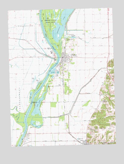
Meredosia, IL USGS Topographic Map
Click on map above to begin viewing in our Map Viewer.

This topographic map contains these locations and features:
Feature Name Type Latitude Longitude GNIS ID View Map
Augustine CemeteryCemeteryN39.7987°W90.5162°1822097View Map
Barlow LakeLakeN39.7964°W90.6004°403903View Map
Billings LakeLakeN39.8656°W90.5790°404446View Map
BluffsPopulated PlaceN39.7520°W90.5351°404628View Map
Bluffs High SchoolSchoolN39.7539°W90.5360°1821144View Map
Bluffs Post OfficePost OfficeN39.7504°W90.5341°2788688View Map
Bluffs United Methodist ChurchChurchN39.7520°W90.5354°2040105View Map
Burns School (historical)SchoolN39.7728°W90.5668°405247View Map
Carver LakeLakeN39.8408°W90.5686°405665View Map
Chisel LakeLakeN39.8113°W90.5954°406072View Map
Collins CemeteryCemeteryN39.7612°W90.5918°1985664View Map
Columbus (historical)Populated PlaceN39.7639°W90.6043°1821147View Map
Coon RunStreamN39.7759°W90.6021°406542View Map
Eagle IslandIslandN39.8692°W90.5835°1720917View Map
Eagle RunStreamN39.7789°W90.5554°407576View Map
Fairview CemeteryCemeteryN39.7648°W90.5204°1747968View Map
First Baptist ChurchChurchN39.8342°W90.5573°2040104View Map
Hodges CemeteryCemeteryN39.8153°W90.5062°1720926View Map
Kiel CemeteryCemeteryN39.8514°W90.5340°1720929View Map
McCaleb CemeteryCemeteryN39.7756°W90.5271°1747969View Map
McGees IslandIslandN39.8500°W90.5668°422211View Map
McKee CreekStreamN39.7723°W90.6085°424544View Map
MeredosiaPopulated PlaceN39.8312°W90.5596°413420View Map
Meredosia City Rescue SquadBuildingN39.8300°W90.5617°2640331View Map
Meredosia Fire DepartmentBuildingN39.8300°W90.5616°2640192View Map
Meredosia LakeLakeN39.8734°W90.5514°413423View Map
Meredosia National Wildlife RefugeParkN39.8715°W90.5694°1720433View Map
Meredosia Number 1 Election PrecinctCivilN39.8548°W90.5052°1928565View Map
Meredosia Number 2 Election PrecinctCivilN39.8115°W90.5238°1928566View Map
Meredosia Post OfficePost OfficeN39.8302°W90.5615°2788336View Map
Meredosia Power StationBuildingN39.8228°W90.5669°2419850View Map
Meredosia-Chambersburg High SchoolSchoolN39.8314°W90.5546°1822120View Map
NaplesPopulated PlaceN39.7573°W90.6073°414285View Map
Naples CemeteryCemeteryN39.7681°W90.6004°1747970View Map
New Salem CemeteryCemeteryN39.8114°W90.5093°1720937View Map
Oakland CemeteryCemeteryN39.8270°W90.5543°1720940View Map
Saint John's Lutheran ChurchChurchN39.7512°W90.5365°2040106View Map
Saint Patrick Catholic ChurchChurchN39.7512°W90.5379°2040107View Map
Sand Ridge School (historical)SchoolN39.8542°W90.5937°417952View Map
Seamans PondLakeN39.8043°W90.5803°1720944View Map
Shady AcresPopulated PlaceN39.8473°W90.5546°1720945View Map
Smith LakeLakeN39.7864°W90.5919°418638View Map
South Fork McKee CreekStreamN39.7781°W90.6207°418767View Map
Spring RunStreamN39.7967°W90.5423°418986View Map
Sycamore School (historical)SchoolN39.8162°W90.5068°419503View Map
Town of NaplesCivilN39.7535°W90.6069°2396795View Map
Unique School (historical)SchoolN39.8556°W90.5335°420149View Map
Village of MeredosiaCivilN39.8311°W90.5571°2399316View Map
Willow CreekStreamN39.8512°W90.5610°421240View Map
Wilsons IslandIslandN39.8509°W90.5798°1720955View Map
Wolf RunStreamN39.7784°W90.5576°421396View Map
Woods LakeLakeN39.8098°W90.5905°421480View Map

Note: Coordinates in the location and feature list above are referenced to NAD83 datum.


Copyright (C) 2008-2025 Ryan Niemi / Sunset Dynamics ... All Rights Reserved