TopoQuest Logo
Do you find TopoQuest useful?
Help keep TopoQuest running and adding new maps/features by donating!
Bitcoin:  19c7KJd3qBynnjoSw5npx9KScwjBe4ifkT
Litecoin:  LXs6TkuXGGXo1vDsWCkWVdjQX94eUKd6ui
Home View Maps Find Maps Find Places Resources & Links


Mesa Cortada, New Mexico Topographic Map

USGS Map Title: Mesa Cortada, NM
USGS Map MRC: 35107E4
DRG (GeoTIFF) Download: o35107e4.tif


Neighboring USGS Topographic Map Quads:


  Mesita Americana, NM  
35107F5
 

  Mesita Del Gavilan, NM  
35107F4
 

  Canada Calladita, NM  
35107F3
 

  El Dado, NM  
35107E5
 

  Mesa Cortada, NM  
35107E4
 

  Cerro Parido, NM  
35107E3
 

  Cerro Alesna, NM  
35107D5
 

  El Dado Mesa, NM  
35107D4
 

  Laguna Seca, NM  
35107D3


Map MRC Location:

N36°
W108°
N36°
W107°
H8 H7 H6 H5 H4 H3 H2 H1
G8 G7 G6 G5 G4 G3 G2 G1
F8 F7 F6 F5 F4 F3 F2 F1
E8 E7 E6 E5 E4 E3 E2 E1
D8 D7 D6 D5 D4 D3 D2 D1
C8 C7 C6 C5 C4 C3 C2 C1
B8 B7 B6 B5 B4 B3 B2 B1
A8 A7 A6 A5 A4 A3 A2 A1
N35°
W108°
N35°
W107°

Mesa Cortada, NM USGS 1:24K Topographic Map Preview:
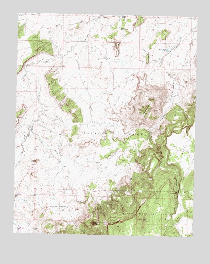
Mesa Cortada, NM USGS Topographic Map
Click on map above to begin viewing in our Map Viewer.

This topographic map contains these locations and features:
Feature Name Type Latitude Longitude GNIS ID View Map
Arroyo Alfredo PadillaArroyoN35.6225°W107.4470°903356View Map
Arroyo ChavezArroyoN35.5478°W107.4762°903365View Map
Arroyo SarcioArroyoN35.5600°W107.4901°903416View Map
BattleshipSummitN35.6086°W107.4314°903610View Map
Candido TankReservoirN35.6250°W107.4301°887132View Map
Cerro ChavezSummitN35.5064°W107.4445°904958View Map
Cerro ColoradoSummitN35.5089°W107.4112°904965View Map
Chavez CanyonValleyN35.5111°W107.4609°905053View Map
Gonzolas TankReservoirN35.6171°W107.4293°906644View Map
Jaramillo RanchLocaleN35.5025°W107.4864°907316View Map
Los Indios CanyonValleyN35.5750°W107.3939°908213View Map
LuceroLocaleN35.5778°W107.3806°927336View Map
Mesa CortadaSummitN35.5695°W107.4109°908596View Map
Mesa CrotaloSummitN35.6056°W107.4150°908597View Map
Mesa SarcioSummitN35.5409°W107.4862°908636View Map
Michael RanchLocaleN35.5214°W107.4992°908673View Map
Ojo de los IndiosSpringN35.5247°W107.3870°909291View Map
Ojo NavajoSpringN35.5322°W107.4200°909324View Map
R-11 Water WellWellN35.5931°W107.3895°921783View Map
Rancho de la PuntaLocaleN35.6017°W107.4726°909991View Map
Rincon ChavezBasinN35.5153°W107.4695°910192View Map
Rincon GrandeValleyN35.5975°W107.3962°910198View Map
Rincon Grande TankReservoirN35.6057°W107.3960°910199View Map
San Miguel CreekStreamN35.5917°W107.4934°910677View Map
San Miguel Creek DomeSummitN35.5706°W107.4673°910678View Map
White MesaSummitN35.5656°W107.4992°912307View Map

Note: Coordinates in the location and feature list above are referenced to NAD83 datum.


Copyright (C) 2008-2025 Ryan Niemi / Sunset Dynamics ... All Rights Reserved