TopoQuest Logo
Do you find TopoQuest useful?
Help keep TopoQuest running and adding new maps/features by donating!
Bitcoin:  19c7KJd3qBynnjoSw5npx9KScwjBe4ifkT
Litecoin:  LXs6TkuXGGXo1vDsWCkWVdjQX94eUKd6ui
Home View Maps Find Maps Find Places Resources & Links


Metompkin Inlet, Virginia Topographic Map

USGS Map Title: Metompkin Inlet, VA
USGS Map MRC: 37075F5
DRG (GeoTIFF) Download: o37075f5.tif


Neighboring USGS Topographic Map Quads:


  Parksley, VA  
37075G6
 

  Bloxom, VA  
37075G5
 

  Wallops Island, VA  
37075G4
 

  Accomac, VA  
37075F6
 

  Metompkin Inlet, VA  
37075F5


Map MRC Location:

N38°
W76°
N38°
W75°
H8 H7 H6 H5 H4 H3 H2 H1
G8 G7 G6 G5 G4 G3 G2 G1
F8 F7 F6 F5 F4 F3 F2 F1
E8 E7 E6 E5 E4 E3 E2 E1
D8 D7 D6 D5 D4 D3 D2 D1
C8 C7 C6 C5 C4 C3 C2 C1
B8 B7 B6 B5 B4 B3 B2 B1
A8 A7 A6 A5 A4 A3 A2 A1
N37°
W76°
N37°
W75°

Metompkin Inlet, VA USGS 1:24K Topographic Map Preview:
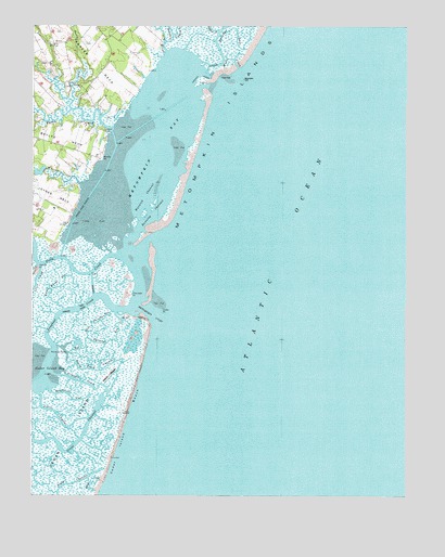
Metompkin Inlet, VA USGS Topographic Map
Click on map above to begin viewing in our Map Viewer.

This topographic map contains these locations and features:
Feature Name Type Latitude Longitude GNIS ID View Map
Battle PointCapeN37.7143°W75.6016°1480084View Map
Baylys NeckCapeN37.7201°W75.6244°1462844View Map
Big Thrasher GutGutN37.6662°W75.5994°1463423View Map
Bundick CreekStreamN37.7435°W75.5808°1464093View Map
Cedar IslandIslandN37.6321°W75.6127°1464629View Map
Cedar Island BayBayN37.6599°W75.6216°1464630View Map
Cedar Island BeachBeachN37.6282°W75.6002°1464631View Map
Cedar PointCapeN37.6715°W75.5813°1464642View Map
Crippen CreekStreamN37.7482°W75.5785°1465436View Map
Deep CreekStreamN37.7349°W75.5569°1465697View Map
Flounder PointCapeN37.6785°W75.5916°1466732View Map
Folly CreekStreamN37.6890°W75.5963°1466746View Map
Great ChannelChannelN37.6393°W75.6216°1467423View Map
Great GutGutN37.6282°W75.6041°1467435View Map
Henrys PointCapeN37.6860°W75.6233°1480083View Map
Knock Knees GutGutN37.6812°W75.6152°1469073View Map
Little ChannelChannelN37.6451°W75.6155°1469499View Map
Little Thrasher GutGutN37.6710°W75.6038°1469669View Map
Longboat CreekStreamN37.6751°W75.5921°1469844View Map
Metompkin BayBayN37.7182°W75.5833°1470380View Map
Metompkin InletBayN37.6801°W75.5819°1470382View Map
North Fork Parker CreekStreamN37.7282°W75.6124°1471615View Map
Parker CreekStreamN37.7224°W75.5988°1472060View Map
Parker NeckCapeN37.7404°W75.6049°1472063View Map
Point of RocksCapeN37.6643°W75.6185°1472559View Map
Poplar CreekStreamN37.7490°W75.5635°1472645View Map
Round Rock ChannelChannelN37.6979°W75.5813°1473590View Map
Running ChannelChannelN37.7004°W75.5849°1473631View Map
Sloop ChannelChannelN37.6265°W75.6158°1474696View Map
Snead BeachBeachN37.6571°W75.5991°1474803View Map
Snead Beach ChannelChannelN37.6571°W75.5991°1474804View Map
Southwest GutGutN37.6510°W75.6119°1474919View Map
Straight CreekStreamN37.6571°W75.6158°1475232View Map
Virginia Inside PassageChannelN37.7199°W75.5955°1496456View Map
Walston CreekStreamN37.7079°W75.6091°1476291View Map
Walston Creek DamDamN37.7118°W75.6213°1488982View Map
Warwick ChannelChannelN37.7046°W75.5874°1476351View Map

Note: Coordinates in the location and feature list above are referenced to NAD83 datum.


Copyright (C) 2008-2024 Ryan Niemi / Sunset Dynamics ... All Rights Reserved