TopoQuest Logo
Do you find TopoQuest useful?
Help keep TopoQuest running and adding new maps/features by donating!
Bitcoin:  19c7KJd3qBynnjoSw5npx9KScwjBe4ifkT
Litecoin:  LXs6TkuXGGXo1vDsWCkWVdjQX94eUKd6ui
Home View Maps Find Maps Find Places Resources & Links


Mica Mountain, Arizona Topographic Map

USGS Map Title: Mica Mountain, AZ
USGS Map MRC: 32110B5
DRG (GeoTIFF) Download: o32110b5.tif


Neighboring USGS Topographic Map Quads:


  Agua Caliente Hill, AZ  
32110C6
 

  Piety Hill, AZ  
32110C5
 

  Soza Canyon, AZ  
32110C4
 

  Tanque Verde Peak, AZ  
32110B6
 

  Mica Mountain, AZ  
32110B5
 

  Happy Valley, AZ  
32110B4
 

  Vail, AZ  
32110A6
 

  Rincon Peak, AZ  
32110A5
 

  Galleta Flat West, AZ  
32110A4


Map MRC Location:

N33°
W111°
N33°
W110°
H8 H7 H6 H5 H4 H3 H2 H1
G8 G7 G6 G5 G4 G3 G2 G1
F8 F7 F6 F5 F4 F3 F2 F1
E8 E7 E6 E5 E4 E3 E2 E1
D8 D7 D6 D5 D4 D3 D2 D1
C8 C7 C6 C5 C4 C3 C2 C1
B8 B7 B6 B5 B4 B3 B2 B1
A8 A7 A6 A5 A4 A3 A2 A1
N32°
W111°
N32°
W110°

Mica Mountain, AZ USGS 1:24K Topographic Map Preview:
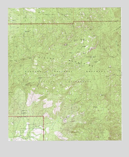
Mica Mountain, AZ USGS Topographic Map
Click on map above to begin viewing in our Map Viewer.

This topographic map contains these locations and features:
Feature Name Type Latitude Longitude GNIS ID View Map
Anillo TankReservoirN32.2460°W110.5894°25660View Map
Arts SpringSpringN32.2231°W110.5315°37156View Map
Chimenea CanyonValleyN32.1350°W110.6067°27586View Map
Chimenea Natural AreaParkN32.1529°W110.5409°37228View Map
Cow Head SaddleGapN32.2037°W110.5990°28087View Map
Cow Head Trail SpringSpringN32.1523°W110.5506°37253View Map
Deer Head SpringSpringN32.1981°W110.5340°28378View Map
Devils BathtubSpringN32.1973°W110.5459°28434View Map
Douglas Camp SpringSpringN32.2277°W110.6068°28576View Map
Douglas Spring CampgroundLocaleN32.2279°W110.6067°1951600View Map
Douglas Spring TrailTrailN32.2306°W110.6173°1951599View Map
DuckbillSummitN32.2084°W110.5460°28656View Map
Grass Shack SpringSpringN32.1844°W110.5924°29540View Map
Happy Valley LookoutLocaleN32.1684°W110.5231°29741View Map
Happy Valley SaddleGapN32.1567°W110.5251°29742View Map
Head Trails SpringsSpringN32.1581°W110.6109°37334View Map
Heartbreak Ridge TrailTrailN32.1717°W110.5240°1951598View Map
Helens DomeSummitN32.2152°W110.5615°29855View Map
Italian SpringSpringN32.2291°W110.5359°30439View Map
Madrona CanyonValleyN32.1363°W110.6009°31433View Map
Madrona Ranger StationLocaleN32.1537°W110.6087°31434View Map
Man HeadSummitN32.2078°W110.5427°31476View Map
Manning CampLocaleN32.2095°W110.5540°31484View Map
Mica MeadowFlatN32.2134°W110.5395°37403View Map
Mica MountainSummitN32.2199°W110.5435°31794View Map
Mule Deer TankReservoirN32.2379°W110.6208°37425View Map
Reef RockSummitN32.2112°W110.5347°33554View Map
Rincon MountainsRangeN32.1320°W110.5195°33630View Map
Saguaro National ParkParkN32.1787°W110.6079°10683View Map
Saguaro National Park East Unit (historical)ParkN32.1667°W110.5840°37506View Map
Spud RockSummitN32.2188°W110.5505°34756View Map
Spud Rock CabinLocaleN32.2023°W110.5356°34757View Map
Spud Rock SpringSpringN32.2042°W110.5321°37534View Map
Sycamore CreekStreamN32.1901°W110.5026°37545View Map
Turkey Creek SpringSpringN32.1917°W110.5076°42958View Map
Turkey SpringSpringN32.2146°W110.5053°12877View Map
Turtle SpringSpringN32.2156°W110.5051°37568View Map
Wasp SpringSpringN32.1720°W110.6245°35913View Map
X 9 RanchLocaleN32.1317°W110.6126°36417View Map

Note: Coordinates in the location and feature list above are referenced to NAD83 datum.


Copyright (C) 2008-2024 Ryan Niemi / Sunset Dynamics ... All Rights Reserved