TopoQuest Logo
Do you find TopoQuest useful?
Help keep TopoQuest running and adding new maps/features by donating!
Bitcoin:  19c7KJd3qBynnjoSw5npx9KScwjBe4ifkT
Litecoin:  LXs6TkuXGGXo1vDsWCkWVdjQX94eUKd6ui
Home View Maps Find Maps Find Places Resources & Links


Michigan Center, Michigan Topographic Map

USGS Map Title: Michigan Center, MI
USGS Map MRC: 42084B3
DRG (GeoTIFF) Download: o42084b3.tif


Neighboring USGS Topographic Map Quads:


  Jackson North, MI  
42084C4
 

  Gilletts Lake, MI  
42084C3
 

  Grass Lake, MI  
42084C2
 

  Jackson South, MI  
42084B4
 

  Michigan Center, MI  
42084B3
 

  Norvell, MI  
42084B2
 

  Somerset Center, MI  
42084A4
 

  Cement City, MI  
42084A3
 

  Onsted, MI  
42084A2


Map MRC Location:

N43°
W85°
N43°
W84°
H8 H7 H6 H5 H4 H3 H2 H1
G8 G7 G6 G5 G4 G3 G2 G1
F8 F7 F6 F5 F4 F3 F2 F1
E8 E7 E6 E5 E4 E3 E2 E1
D8 D7 D6 D5 D4 D3 D2 D1
C8 C7 C6 C5 C4 C3 C2 C1
B8 B7 B6 B5 B4 B3 B2 B1
A8 A7 A6 A5 A4 A3 A2 A1
N42°
W85°
N42°
W84°

Michigan Center, MI USGS 1:24K Topographic Map Preview:
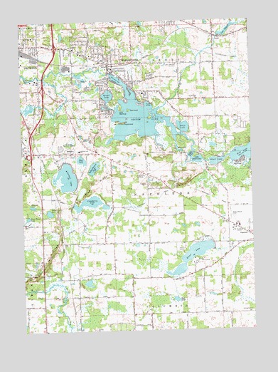
Michigan Center, MI USGS Topographic Map
Click on map above to begin viewing in our Map Viewer.

This topographic map contains these locations and features:
Feature Name Type Latitude Longitude GNIS ID View Map
Ackerson LakeLakeN42.1871°W84.3505°619801View Map
Ackerson Lake SchoolSchoolN42.1978°W84.3436°619802View Map
Ackerson Lake Station (historical)LocaleN42.1806°W84.3453°2633081View Map
Ackerson Post Office (historical)Post OfficeN42.1806°W84.3453°2633087View Map
Arnold SchoolSchoolN42.2381°W84.3425°620243View Map
Blue RidgeRidgeN42.1570°W84.3589°621646View Map
Booth DrainCanalN42.2014°W84.3733°621732View Map
Center LakeReservoirN42.2110°W84.3115°622980View Map
Christ Lutheran ChurchChurchN42.2364°W84.3367°2632979View Map
Church of God of ProphecyChurchN42.1972°W84.3367°2632476View Map
Clarklake SchoolSchoolN42.1250°W84.3358°623375View Map
Cranberry LakeLakeN42.1775°W84.3369°623967View Map
Dollar LakeLakeN42.1959°W84.2825°624751View Map
Dyke PeninsulaCapeN42.2142°W84.3200°625064View Map
Eldred CemeteryCemeteryN42.1972°W84.3403°2633099View Map
Eldred Post Office (historical)Post OfficeN42.1944°W84.3269°2631477View Map
Eldred Station (historical)LocaleN42.1944°W84.3269°2633076View Map
Faith Baptist ChapelChurchN42.1778°W84.2862°2632967View Map
Fatima SchoolSchoolN42.2209°W84.3083°625856View Map
Goat IslandIslandN42.2142°W84.3161°626907View Map
Green LakeLakeN42.1728°W84.3605°627302View Map
Green Valley Golf ClubLocaleN42.1881°W84.3111°1623378View Map
Hammer LakeLakeN42.1753°W84.3697°627694View Map
Hope ChurchChurchN42.1945°W84.3558°628560View Map
Huttenlocher DrainCanalN42.2348°W84.2594°628894View Map
Indian Village Mobile Home ParkPopulated PlaceN42.2194°W84.3547°2632149View Map
Jackson Free Methodist ChurchChurchN42.2033°W84.3725°2632477View Map
Keicher Elementary SchoolSchoolN42.2297°W84.3247°2632982View Map
Lake Land Hills Golf ClubLocaleN42.2325°W84.2897°1623475View Map
LeoniPopulated PlaceN42.2439°W84.2691°630321View Map
Leoni CemeteryCemeteryN42.2408°W84.2697°2633097View Map
Leoni MillpondLakeN42.2451°W84.2635°630322View Map
Leoni Post Office (historical)Post OfficeN42.2439°W84.2692°2631474View Map
Leoni StationLocaleN42.2439°W84.2694°2633071View Map
Leoni Township Fire Department Station 1 HeadquartersBuildingN42.2236°W84.3265°2635995View Map
Leoni Township Police DepartmentBuildingN42.2236°W84.3265°2737369View Map
Little Olcott LakeLakeN42.1943°W84.2805°630717View Map
Maple IslandIslandN42.2089°W84.3191°631472View Map
Michigan CenterPopulated PlaceN42.2331°W84.3272°632205View Map
Michigan Center Bible ChurchChurchN42.2308°W84.3250°2632978View Map
Michigan Center Census Designated PlaceCensusN42.2268°W84.3230°2393128View Map
Michigan Center High SchoolSchoolN42.2239°W84.3383°632206View Map
Michigan Center Post OfficePost OfficeN42.2305°W84.3258°2632980View Map
Michigan Center Station (historical)LocaleN42.2319°W84.3264°2632975View Map
Moon LakeLakeN42.1978°W84.2891°632622View Map
Mud LakeLakeN42.1376°W84.2924°632902View Map
Mud LakeLakeN42.1942°W84.3427°632903View Map
Napoleon AirportAirportN42.1671°W84.2588°1624065View Map
Napoleon Fire DepartmentBuildingN42.1669°W84.2617°2632962View Map
Napoleon Township Fire Department Station 1 HeadquartersBuildingN42.1669°W84.2617°2636112View Map
Napoleon Township Fire Department Station 2BuildingN42.1959°W84.3493°2636105View Map
Napoleon Township Police DepartmentBuildingN42.1668°W84.2616°2737383View Map
Oak PointPopulated PlaceN42.1928°W84.2558°633855View Map
Olcott LakeLakeN42.1931°W84.2694°634150View Map
Page Ave ChurchChurchN42.2328°W84.3094°634287View Map
Pentecostal Lighthouse ChurchChurchN42.2294°W84.3280°2632977View Map
Peter White LakeLakeN42.1709°W84.3721°634698View Map
Price LakeLakeN42.2072°W84.2867°635450View Map
Roseland Memorial GardensCemeteryN42.1984°W84.3486°636230View Map
Round LakeLakeN42.2200°W84.3277°636281View Map
Saint Aidans ChurchChurchN42.2223°W84.3222°636515View Map
Schoolhouse LakeLakeN42.1909°W84.3361°637424View Map
Shady Park Mobile Home CommunityPopulated PlaceN42.2020°W84.3419°2632968View Map
Stony LakeLakeN42.1549°W84.2831°638910View Map
Townsend DrainCanalN42.1803°W84.2983°1615017View Map
Township of NapoleonCivilN42.1754°W84.2925°1626789View Map
Van Wagnen AirportAirportN42.1558°W84.3373°1624066View Map
Wellworth ParkParkN42.2273°W84.3711°1615996View Map

Note: Coordinates in the location and feature list above are referenced to NAD83 datum.


Copyright (C) 2008-2024 Ryan Niemi / Sunset Dynamics ... All Rights Reserved