TopoQuest Logo
Do you find TopoQuest useful?
Help keep TopoQuest running and adding new maps/features by donating!
Bitcoin:  19c7KJd3qBynnjoSw5npx9KScwjBe4ifkT
Litecoin:  LXs6TkuXGGXo1vDsWCkWVdjQX94eUKd6ui
Home View Maps Find Maps Find Places Resources & Links


Midas, Nevada Topographic Map

USGS Map Title: Midas, NV
USGS Map MRC: 41116B7
DRG (GeoTIFF) Download: o41116b7.tif


Neighboring USGS Topographic Map Quads:


  Snowstorm Mountain, NV  
41116C8
 

  Oregon Canyon, NV  
41116C7
 

  Scraper Springs, NV  
41116C6
 

  Jake Creek Mountain, NV  
41116B8
 

  Midas, NV  
41116B7
 

  Squaw Valley Ranch, NV  
41116B6
 

  Midas SW, NV  
41116A8
 

  Sixmile Hill, NV  
41116A7
 

  Rock Creek Ranch, NV  
41116A6


Map MRC Location:

N42°
W117°
N42°
W116°
H8 H7 H6 H5 H4 H3 H2 H1
G8 G7 G6 G5 G4 G3 G2 G1
F8 F7 F6 F5 F4 F3 F2 F1
E8 E7 E6 E5 E4 E3 E2 E1
D8 D7 D6 D5 D4 D3 D2 D1
C8 C7 C6 C5 C4 C3 C2 C1
B8 B7 B6 B5 B4 B3 B2 B1
A8 A7 A6 A5 A4 A3 A2 A1
N41°
W117°
N41°
W116°

Midas, NV USGS 1:24K Topographic Map Preview:
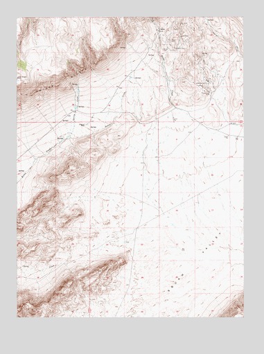
Midas, NV USGS Topographic Map
Click on map above to begin viewing in our Map Viewer.

This topographic map contains these locations and features:
Feature Name Type Latitude Longitude GNIS ID View Map
Acme G MineMineN41.2252°W116.7659°852082View Map
Box Canyon ReservoirReservoirN41.1255°W116.8440°849590View Map
Esmeralda GroupMineN41.2221°W116.7712°840379View Map
Esmeralda MineMineN41.2177°W116.7695°840380View Map
Fairlawn (historical)Populated PlaceN41.1721°W116.7759°852076View Map
Fairlawn Post Office (historical)Post OfficeN41.1721°W116.7759°864355View Map
Gold Circle MineMineN41.2485°W116.8004°855638View Map
Gold Circle Mining DistrictCivilN41.2455°W116.7904°856614View Map
Gold Crown MineMineN41.2455°W116.7890°855637View Map
Horseshoe MountainSummitN41.1730°W116.8596°849579View Map
Jackson MineMineN41.2368°W116.7879°841350View Map
Link MineMineN41.2418°W116.7851°841650View Map
MidasPopulated PlaceN41.2441°W116.7968°845906View Map
Midas CemeteryCemeteryN41.2363°W116.7952°842071View Map
Midas MineMineN41.2405°W116.7907°842072View Map
Midas Post Office (historical)Post OfficeN41.2441°W116.7968°864609View Map
Midas Volunteer Fire DepartmentBuildingN41.2446°W116.7970°2581407View Map
Rex MillLocaleN41.2443°W116.7982°855844View Map
Rex MineMineN41.2468°W116.7851°843205View Map
Saint Paul MineMineN41.2355°W116.7865°855636View Map
Spring CreekStreamN41.2002°W116.8471°843933View Map
Summit (historical)Populated PlaceN41.2252°W116.8134°852075View Map
Summit CreekStreamN41.2002°W116.8471°844078View Map
Summit Post Office (historical)Post OfficeN41.2252°W116.8134°864354View Map
Wilkinson RanchLocaleN41.2055°W116.8382°844884View Map

Note: Coordinates in the location and feature list above are referenced to NAD83 datum.


Copyright (C) 2008-2025 Ryan Niemi / Sunset Dynamics ... All Rights Reserved