TopoQuest Logo
Do you find TopoQuest useful?
Help keep TopoQuest running and adding new maps/features by donating!
Bitcoin:  19c7KJd3qBynnjoSw5npx9KScwjBe4ifkT
Litecoin:  LXs6TkuXGGXo1vDsWCkWVdjQX94eUKd6ui
Home View Maps Find Maps Find Places Resources & Links


Miles City, Florida Topographic Map

USGS Map Title: Miles City, FL
USGS Map MRC: 26081B3
DRG (GeoTIFF) Download: o26081b3.tif


Neighboring USGS Topographic Map Quads:


  Immokalee SW, FL  
26081C4
 

  Sunniland, FL  
26081C3


  Catherine Island, FL  
26081B4
 

  Miles City, FL  
26081B3


  Deep Lake SW, FL  
26081A4
 

  Deep Lake, FL  
26081A3


Map MRC Location:

N27°
W82°
N27°
W81°
H8 H7 H6 H5 H4 H3 H2 H1
G8 G7 G6 G5 G4 G3 G2 G1
F8 F7 F6 F5 F4 F3 F2 F1
E8 E7 E6 E5 E4 E3 E2 E1
D8 D7 D6 D5 D4 D3 D2 D1
C8 C7 C6 C5 C4 C3 C2 C1
B8 B7 B6 B5 B4 B3 B2 B1
A8 A7 A6 A5 A4 A3 A2 A1
N26°
W82°
N26°
W81°

Miles City, FL USGS 1:24K Topographic Map Preview:
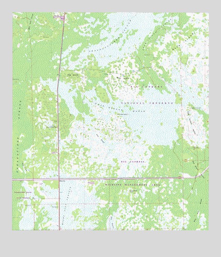
Miles City, FL USGS Topographic Map
Click on map above to begin viewing in our Map Viewer.

This topographic map contains these locations and features:
Feature Name Type Latitude Longitude GNIS ID View Map
Bear IslandIslandN26.2323°W81.2659°278322View Map
Bear Island StrandSwampN26.2365°W81.2829°278331View Map
Deep SloughSwampN26.1784°W81.3187°281435View Map
Deliverance Evangelistic ChurchChurchN26.1823°W81.2554°301272View Map
East Hinson Indian MoundsSummitN26.1731°W81.2598°281988View Map
East Hinson IslandIslandN26.1851°W81.2598°281989View Map
East Hinson MarshSwampN26.1959°W81.3065°281990View Map
Harold StrandSwampN26.1898°W81.2526°307492View Map
Hog IslandIslandN26.2143°W81.3370°284081View Map
Lone Chicken IslandIslandN26.1481°W81.3001°285940View Map
Miles CityPopulated PlaceN26.1543°W81.3445°295450View Map
Miles City Lookout TowerTowerN26.1845°W81.3462°286842View Map
Miles City PrairieSwampN26.1363°W81.3404°286843View Map
Model T FlatFlatN26.1612°W81.3662°287044View Map
North Collier Church of ChristChurchN26.2045°W81.2970°301276View Map
Our Saviour Lutheran ChurchChurchN26.1643°W81.2554°301283View Map
Pepper HammockBasinN26.1956°W81.2617°288710View Map
Platt IslandIslandN26.2129°W81.3042°289038View Map
Twin Palms IslandIslandN26.1920°W81.3009°292617View Map

Note: Coordinates in the location and feature list above are referenced to NAD83 datum.


Copyright (C) 2008-2025 Ryan Niemi / Sunset Dynamics ... All Rights Reserved