TopoQuest Logo
Do you find TopoQuest useful?
Help keep TopoQuest running and adding new maps/features by donating!
Bitcoin:  19c7KJd3qBynnjoSw5npx9KScwjBe4ifkT
Litecoin:  LXs6TkuXGGXo1vDsWCkWVdjQX94eUKd6ui
Home View Maps Find Maps Find Places Resources & Links


Mineral, California Topographic Map

USGS Map Title: Mineral, CA
USGS Map MRC: 40121C5
DRG (GeoTIFF) Download: o40121c5.tif


Neighboring USGS Topographic Map Quads:


  Grays Peak, CA  
40121D6
 

  Lassen Peak, CA  
40121D5
 

  Reading Peak, CA  
40121D4
 

  Lyonsville, CA  
40121C6
 

  Mineral, CA  
40121C5
 

  Childs Meadows, CA  
40121C4
 

  Barkley Mountain, CA  
40121B6
 

  Onion Butte, CA  
40121B5
 

  Humboldt Peak, CA  
40121B4


Map MRC Location:

N41°
W122°
N41°
W121°
H8 H7 H6 H5 H4 H3 H2 H1
G8 G7 G6 G5 G4 G3 G2 G1
F8 F7 F6 F5 F4 F3 F2 F1
E8 E7 E6 E5 E4 E3 E2 E1
D8 D7 D6 D5 D4 D3 D2 D1
C8 C7 C6 C5 C4 C3 C2 C1
B8 B7 B6 B5 B4 B3 B2 B1
A8 A7 A6 A5 A4 A3 A2 A1
N40°
W122°
N40°
W121°

Mineral, CA USGS 1:24K Topographic Map Preview:
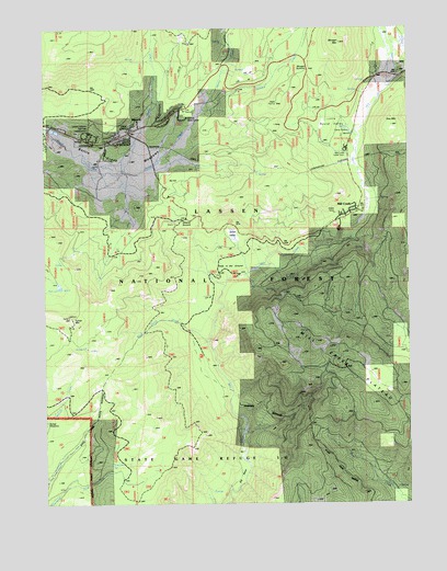
Mineral, CA USGS Topographic Map
Click on map above to begin viewing in our Map Viewer.

This topographic map contains these locations and features:
Feature Name Type Latitude Longitude GNIS ID View Map
Battle Creek MeadowsFlatN40.3410°W121.6003°256595View Map
Bear Wallow CampgroundLocaleN40.3321°W121.5797°256733View Map
Belfast MeadowsFlatN40.2685°W121.6216°256797View Map
Big BendBendN40.2571°W121.5586°256884View Map
Big Bend Camp (historical)LocaleN40.2604°W121.5572°1682331View Map
Black Oak CampgroundLocaleN40.3602°W121.6111°257142View Map
Brokenshire Picnic AreaLocaleN40.3449°W121.5203°1666113View Map
Camp TehamaLocaleN40.3468°W121.5203°257900View Map
Doe MountainSummitN40.3492°W121.5062°259433View Map
Hole in the GroundFlatN40.3124°W121.5644°261418View Map
Hole in the Ground CampgroundLocaleN40.3096°W121.5600°277093View Map
Jones ValleyValleyN40.3187°W121.5595°262011View Map
Lassen Volcanic National Park Fire ManagementBuildingN40.3478°W121.6145°2622298View Map
Lassen Volcanic National Park HeadquartersLocaleN40.3477°W121.6100°1666126View Map
Little Round ValleyBasinN40.3513°W121.5275°262708View Map
Martin CreekStreamN40.3371°W121.5961°263235View Map
Mill CreekPopulated PlaceN40.3263°W121.5228°1659127View Map
Mill Creek CampgroundLocaleN40.3210°W121.5247°277094View Map
Mill Creek PlateauPlainN40.2754°W121.5119°263618View Map
MineralPopulated PlaceN40.3477°W121.5950°1659139View Map
Mineral Elementary SchoolSchoolN40.3459°W121.5967°1692754View Map
Mineral Post OfficePost OfficeN40.3490°W121.5938°2760077View Map
Mineral Ranger StationLocaleN40.3524°W121.5775°1682342View Map
Mineral SummitGapN40.3249°W121.5769°263674View Map
Mineral Work CenterLocaleN40.3510°W121.5766°277074View Map
Morgan MountainSummitN40.3709°W121.5240°1659176View Map
Morgan SpringsPopulated PlaceN40.3621°W121.5111°1659177View Map
Morgan SummitGapN40.3621°W121.5308°1659178View Map
Nanny CreekStreamN40.3535°W121.5700°264001View Map
Pear LakeLakeN40.3074°W121.6211°264594View Map
Rock Gulch CreekStreamN40.2854°W121.6019°265502View Map
Ski HillSummitN40.3343°W121.5800°1659677View Map
Summit CreekStreamN40.3418°W121.5839°267917View Map
Tamarack SpringSpringN40.2587°W121.6012°268086View Map
Tehama County Fire Department Station 20 MineralBuildingN40.3479°W121.6151°2622059View Map
Turner MountainSummitN40.2987°W121.6170°268496View Map
Turner Mountain LookoutLocaleN40.2979°W121.6169°277095View Map
White Sulphur SpringSpringN40.3563°W121.5636°269024View Map

Note: Coordinates in the location and feature list above are referenced to NAD83 datum.


Copyright (C) 2008-2025 Ryan Niemi / Sunset Dynamics ... All Rights Reserved