TopoQuest Logo
Do you find TopoQuest useful?
Help keep TopoQuest running and adding new maps/features by donating!
Bitcoin:  19c7KJd3qBynnjoSw5npx9KScwjBe4ifkT
Litecoin:  LXs6TkuXGGXo1vDsWCkWVdjQX94eUKd6ui
Home View Maps Find Maps Find Places Resources & Links


Mineral King, California Topographic Map

USGS Map Title: Mineral King, CA
USGS Map MRC: 36118D5
DRG (GeoTIFF) Download: o36118d5.tif


Neighboring USGS Topographic Map Quads:


  Lodgepole, CA  
36118E6
 

  Triple Divide Peak, CA  
36118E5
 

  Mount Kaweah, CA  
36118E4
 

  Silver City, CA  
36118D6
 

  Mineral King, CA  
36118D5
 

  Chagoopa Falls, CA  
36118D4
 

  Moses Mountain, CA  
36118C6
 

  Quinn Peak, CA  
36118C5
 

  Kern Lake, CA  
36118C4


Map MRC Location:

N37°
W119°
N37°
W118°
H8 H7 H6 H5 H4 H3 H2 H1
G8 G7 G6 G5 G4 G3 G2 G1
F8 F7 F6 F5 F4 F3 F2 F1
E8 E7 E6 E5 E4 E3 E2 E1
D8 D7 D6 D5 D4 D3 D2 D1
C8 C7 C6 C5 C4 C3 C2 C1
B8 B7 B6 B5 B4 B3 B2 B1
A8 A7 A6 A5 A4 A3 A2 A1
N36°
W119°
N36°
W118°

Mineral King, CA USGS 1:24K Topographic Map Preview:
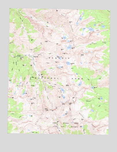
Mineral King, CA USGS Topographic Map
Click on map above to begin viewing in our Map Viewer.

This topographic map contains these locations and features:
Feature Name Type Latitude Longitude GNIS ID View Map
Amphitheater LakeLakeN36.4458°W118.5522°269518View Map
Ansel LakeLakeN36.3929°W118.5988°269544View Map
Aspen FlatFlatN36.4334°W118.5875°274646View Map
Big Five LakesLakeN36.4801°W118.5247°269826View Map
Black Rock PassGapN36.4861°W118.5518°269897View Map
Bullfrog LakesLakeN36.3972°W118.5529°270079View Map
Bullion FlatFlatN36.3866°W118.5651°274645View Map
Chihuahua MineMineN36.4455°W118.5762°1667565View Map
Cold SpringSpringN36.4505°W118.6121°274640View Map
Cold Spring CampgroundLocaleN36.4519°W118.6123°276459View Map
Cold Spring CampgroundLocaleN36.4516°W118.6120°276314View Map
Columbine LakeLakeN36.4617°W118.5511°270568View Map
Crabtree Cabin (historical)LocaleN36.4236°W118.5923°274641View Map
Crystal CreekStreamN36.4378°W118.5903°270697View Map
Crystal LakeReservoirN36.4418°W118.5625°270699View Map
Crystal Lake 104-019 DamDamN36.4416°W118.5643°1663703View Map
Cyclamen LakeLakeN36.4679°W118.5522°270735View Map
Eagle CreekStreamN36.4388°W118.5917°270964View Map
Eagle LakeLakeN36.4151°W118.6063°270966View Map
Eagle SinkholeBasinN36.4294°W118.5990°274643View Map
Empire Mill (historical)LocaleN36.4583°W118.5965°1667576View Map
Empire MineMineN36.4655°W118.5848°1667577View Map
Empire MountainSummitN36.4673°W118.5772°271063View Map
Farewell CanyonValleyN36.4281°W118.5834°271105View Map
Farewell GapGapN36.3994°W118.5715°271106View Map
Forester LakeLakeN36.4114°W118.5104°274639View Map
Franklin CreekStreamN36.4282°W118.5834°271202View Map
Franklin LakesLakeN36.4189°W118.5586°271203View Map
Franklin PassGapN36.4120°W118.5466°271204View Map
Glacier PassTrailN36.4633°W118.5659°274647View Map
Hengst PeakSummitN36.4104°W118.6217°274711View Map
Lady Franklin Lake 104-011 DamDamN36.4216°W118.5609°1663700View Map
Lady Franklin MineMineN36.4222°W118.5720°1667595View Map
Little Claire LakeLakeN36.4220°W118.5215°272082View Map
Little Five LakesLakeN36.4905°W118.5374°255623View Map
Mineral CreekStreamN36.4516°W118.6201°272486View Map
Mineral KingPopulated PlaceN36.4508°W118.5948°1667918View Map
Mineral King Game RefugeParkN36.4424°W118.5876°272487View Map
Mineral King Post Office (historical)Post OfficeN36.4508°W118.5948°1665194View Map
Mineral King Ranger StationLocaleN36.4524°W118.6101°272488View Map
Mineral LakesLakeN36.4294°W118.6236°272489View Map
Mineral PeakSummitN36.4467°W118.5651°272491View Map
Miners NoseSummitN36.4429°W118.6054°274638View Map
Miners RidgeRidgeN36.4116°W118.6120°274642View Map
Monarch CreekStreamN36.4522°W118.5987°272524View Map
Monarch LakesLakeN36.4533°W118.5658°272526View Map
Mosquito CreekStreamN36.4513°W118.6170°272568View Map
Mosquito LakesLakeN36.4193°W118.6139°272569View Map
Mount EisenSummitN36.4983°W118.5685°271022View Map
Mount FlorenceSummitN36.4062°W118.5509°271160View Map
Needham MountainSummitN36.4543°W118.5374°272630View Map
Pinto LakeLakeN36.4863°W118.5799°273012View Map
Rainbow MountainSummitN36.4238°W118.5502°1661275View Map
Sawtooth PassGapN36.4602°W118.5626°273595View Map
Sawtooth PeakSummitN36.4552°W118.5555°1655009View Map
Shotgun PassGapN36.3900°W118.5370°273687View Map
Silver LakeLakeN36.3827°W118.5331°273709View Map
Soda SpringSpringN36.4321°W118.5858°274644View Map
Spring LakeLakeN36.4713°W118.5573°273871View Map
Sunny Point Recreation SiteParkN36.4477°W118.5955°276315View Map
Timber GapGapN36.4683°W118.5993°274138View Map
Timber Gap CreekStreamN36.4980°W118.6159°274139View Map
Tufa FallsFallsN36.4438°W118.5981°274637View Map
Tulare PeakSummitN36.4120°W118.5634°274213View Map
Upper Monarch Lake 104-020 DamDamN36.4533°W118.5659°1663704View Map
Vandever MountainSummitN36.3984°W118.5812°274316View Map
White Chief LakeLakeN36.4094°W118.5993°274465View Map
White Chief MineMineN36.4105°W118.5915°1667627View Map
White Chief PeakSummitN36.4053°W118.5977°1661679View Map

Note: Coordinates in the location and feature list above are referenced to NAD83 datum.


Copyright (C) 2008-2025 Ryan Niemi / Sunset Dynamics ... All Rights Reserved