TopoQuest Logo
Do you find TopoQuest useful?
Help keep TopoQuest running and adding new maps/features by donating!
Bitcoin:  19c7KJd3qBynnjoSw5npx9KScwjBe4ifkT
Litecoin:  LXs6TkuXGGXo1vDsWCkWVdjQX94eUKd6ui
Home View Maps Find Maps Find Places Resources & Links


Minturn, South Carolina Topographic Map

USGS Map Title: Minturn, SC
USGS Map MRC: 34079E4
DRG (GeoTIFF) Download: o34079e4.tif


Neighboring USGS Topographic Map Quads:


  McColl, SC  
34079F5
 

  Johns, NC  
34079F4
 

  Maxton, NC  
34079F3
 

  Clio, SC  
34079E5
 

  Minturn, SC  
34079E4
 

  Rowland, NC  
34079E3
 

  Bingham, SC  
34079D5
 

  Dillon West, SC  
34079D4
 

  Dillon East, SC  
34079D3


Map MRC Location:

N35°
W80°
N35°
W79°
H8 H7 H6 H5 H4 H3 H2 H1
G8 G7 G6 G5 G4 G3 G2 G1
F8 F7 F6 F5 F4 F3 F2 F1
E8 E7 E6 E5 E4 E3 E2 E1
D8 D7 D6 D5 D4 D3 D2 D1
C8 C7 C6 C5 C4 C3 C2 C1
B8 B7 B6 B5 B4 B3 B2 B1
A8 A7 A6 A5 A4 A3 A2 A1
N34°
W80°
N34°
W79°

Minturn, SC USGS 1:24K Topographic Map Preview:
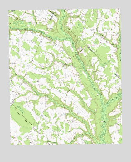
Minturn, SC USGS Topographic Map
Click on map above to begin viewing in our Map Viewer.

This topographic map contains these locations and features:
Feature Name Type Latitude Longitude GNIS ID View Map
Beaverdam CreekStreamN34.5104°W79.4131°1220446View Map
Berea ChurchChurchN34.6249°W79.4953°1220509View Map
Berea School (historical)SchoolN34.6246°W79.4953°1232664View Map
Bull BranchStreamN34.6224°W79.4387°982201View Map
CarolinaPopulated PlaceN34.5746°W79.4381°1236083View Map
Carolina BranchStreamN34.5704°W79.4164°1221362View Map
Carolina ChurchChurchN34.5738°W79.4387°1247168View Map
Carolina Presbyterian Church CemeteryCemeteryN34.5735°W79.4387°1964693View Map
Carolina School (historical)SchoolN34.5735°W79.4373°1236084View Map
Dillon County Fire Department Station 5BuildingN34.5419°W79.4377°2737356View Map
Donohoe BaySwampN34.5263°W79.4867°1247537View Map
Fairview ChurchChurchN34.5679°W79.4031°1247712View Map
Fairview Church CemeteryCemeteryN34.5679°W79.4034°1964696View Map
Glasdrum FarmsLocaleN34.5867°W79.4428°2710699View Map
Hamer Pond Dam D-3595DamN34.5285°W79.4348°1240069View Map
JudsonPopulated PlaceN34.5585°W79.4684°1236122View Map
Judson Church (historical)ChurchN34.5596°W79.4681°1236123View Map
Leith CreekStreamN34.5979°W79.4320°988343View Map
Leland Grove CemeteryCemeteryN34.5840°W79.4220°1964698View Map
Leland Grove ChurchChurchN34.5843°W79.4223°1246330View Map
Leland Grove School (historical)SchoolN34.5868°W79.4192°1236137View Map
Little Rock DivisionCivilN34.5257°W79.4193°1938333View Map
Martins BranchStreamN34.5263°W79.3975°1246548View Map
McGregor BranchStreamN34.5902°W79.3778°989585View Map
McInnis BridgeBridgeN34.5829°W79.4237°1246596View Map
McKays BridgeBridgeN34.5463°W79.3995°1224409View Map
McRae Mill (historical)LocaleN34.5988°W79.4292°1248772View Map
Mill Prong School (historical)SchoolN34.5682°W79.4028°1236150View Map
Millers ChapelChurchN34.5124°W79.4328°1246675View Map
MinturnPopulated PlaceN34.5171°W79.4723°1246695View Map
Minturn ChurchChurchN34.5138°W79.4759°1236151View Map
Minturn School (historical)SchoolN34.5132°W79.4759°1236152View Map
Minturn School (historical)SchoolN34.5202°W79.4681°1236153View Map
Mount Olive ChurchChurchN34.5918°W79.3856°990463View Map
Mount Zion ChurchChurchN34.5088°W79.4817°1249723View Map
New Holy ChurchChurchN34.5510°W79.4542°1249809View Map
New Holy School (historical)SchoolN34.5516°W79.4525°1236161View Map
New Zion ChurchChurchN34.5577°W79.4781°1225035View Map
Number 7 ChurchChurchN34.6060°W79.3850°1023675View Map
Oakland Volunteer Fire DepartmentBuildingN34.5167°W79.3804°2578271View Map
Parishs Mill (historical)LocaleN34.6007°W79.4600°1236170View Map
Pee Dee ChapelChurchN34.6077°W79.4517°1250046View Map
Reedy BranchStreamN34.6068°W79.4717°1250320View Map
Reedy Branch Church (historical)ChurchN34.6160°W79.4837°1232784View Map
Reedy Branch School (historical)SchoolN34.6157°W79.4837°1232785View Map
Sherwood CemeteryCemeteryN34.5057°W79.4120°1226562View Map
Shoe Heel CreekStreamN34.5313°W79.3948°994758View Map
Sinclair CrossroadsPopulated PlaceN34.5274°W79.4648°1250903View Map
Upper South Carolina Pee Dee State Designated Tribal Statistical AreaCensusN34.5276°W79.4160°2564995View Map
Verges Chapel (historical)ChurchN34.5566°W79.4034°1248774View Map
Wash BranchStreamN34.5466°W79.4681°1227415View Map

Note: Coordinates in the location and feature list above are referenced to NAD83 datum.


Copyright (C) 2008-2024 Ryan Niemi / Sunset Dynamics ... All Rights Reserved