TopoQuest Logo
Do you find TopoQuest useful?
Help keep TopoQuest running and adding new maps/features by donating!
Bitcoin:  19c7KJd3qBynnjoSw5npx9KScwjBe4ifkT
Litecoin:  LXs6TkuXGGXo1vDsWCkWVdjQX94eUKd6ui
Home View Maps Find Maps Find Places Resources & Links


Monticello South, Indiana Topographic Map

USGS Map Title: Monticello South, IN
USGS Map MRC: 40086F7
DRG (GeoTIFF) Download: o40086f7.tif


Neighboring USGS Topographic Map Quads:


  Monon, IN  
40086G8
 

  Monticello North, IN  
40086G7
 

  Idaville, IN  
40086G6
 

  Brookston NW, IN  
40086F8
 

  Monticello South, IN  
40086F7
 

  Yeoman, IN  
40086F6
 

  Brookston SW, IN  
40086E8
 

  Brookston, IN  
40086E7
 

  Delphi, IN  
40086E6


Map MRC Location:

N41°
W87°
N41°
W86°
H8 H7 H6 H5 H4 H3 H2 H1
G8 G7 G6 G5 G4 G3 G2 G1
F8 F7 F6 F5 F4 F3 F2 F1
E8 E7 E6 E5 E4 E3 E2 E1
D8 D7 D6 D5 D4 D3 D2 D1
C8 C7 C6 C5 C4 C3 C2 C1
B8 B7 B6 B5 B4 B3 B2 B1
A8 A7 A6 A5 A4 A3 A2 A1
N40°
W87°
N40°
W86°

Monticello South, IN USGS 1:24K Topographic Map Preview:
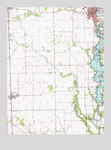
Monticello South, IN USGS Topographic Map
Click on map above to begin viewing in our Map Viewer.

This topographic map contains these locations and features:
Feature Name Type Latitude Longitude GNIS ID View Map
Big CreekStreamN40.6381°W86.7664°431030View Map
Breezy PointPopulated PlaceN40.6920°W86.7531°431474View Map
Bunnell CemeteryCemeteryN40.7378°W86.8606°431817View Map
C and C BeachPopulated PlaceN40.7034°W86.7564°431929View Map
Carr CemeteryCemeteryN40.6419°W86.8651°432169View Map
Cedar PointPopulated PlaceN40.7089°W86.7603°432290View Map
ChalmersPopulated PlaceN40.6631°W86.8695°432383View Map
Chalmers - Brookston First ResponseBuildingN40.6630°W86.8676°2719425View Map
Chalmers CemeteryCemeteryN40.6481°W86.8683°432384View Map
Chalmers Community Volunteer Fire DepartmentBuildingN40.6630°W86.8677°2626428View Map
City of MonticelloCivilN40.7455°W86.7669°2395383View Map
East MonticelloPopulated PlaceN40.7462°W86.7533°433921View Map
Emge DitchCanalN40.6414°W86.8095°434164View Map
Frontier High SchoolSchoolN40.6642°W86.8625°447509View Map
Gingrich AdditionPopulated PlaceN40.6739°W86.7542°435088View Map
Golden HillPopulated PlaceN40.7103°W86.7606°435156View Map
Harvey and Phebus CemeteryCemeteryN40.6474°W86.7853°435848View Map
High CemeteryCemeteryN40.6852°W86.8635°436139View Map
Honey Creek Township First Responder TeamBuildingN40.7479°W86.8735°2719378View Map
Honey Creek Township Volunteer Fire DepartmentBuildingN40.7479°W86.8735°2626595View Map
Indiana University Health White Memorial HospitalHospitalN40.7342°W86.7775°433043View Map
Johnson DitchCanalN40.7264°W86.8658°437051View Map
LakewoodPopulated PlaceN40.6864°W86.7597°437566View Map
Lincoln Junior High SchoolSchoolN40.7445°W86.7661°437915View Map
Lower Sunset ParkPopulated PlaceN40.7070°W86.7545°438374View Map
Meadowlawn Elementary SchoolSchoolN40.7400°W86.7720°443893View Map
MonticelloPopulated PlaceN40.7453°W86.7647°439369View Map
Monticello Fire DepartmentBuildingN40.7463°W86.7632°2625616View Map
Monticello Police DepartmentBuildingN40.7470°W86.7614°2758309View Map
Oakdale DamDamN40.6566°W86.7530°440461View Map
Oaklawn Elementary SchoolSchoolN40.7384°W86.7564°440480View Map
ReynoldsPopulated PlaceN40.7495°W86.8717°441922View Map
Richey ParkPopulated PlaceN40.6686°W86.7592°441956View Map
Roosevelt Junior High SchoolSchoolN40.7442°W86.7725°442283View Map
Roth ParkParkN40.6831°W86.7539°442336View Map
Sandy BeachPopulated PlaceN40.6645°W86.7533°443007View Map
Scarlet OaksPopulated PlaceN40.6956°W86.7542°443059View Map
SmithsonPopulated PlaceN40.7178°W86.8725°443708View Map
Snow DitchCanalN40.7250°W86.8172°443737View Map
Terrace BayBayN40.7186°W86.7503°444646View Map
Town of ChalmersCivilN40.6626°W86.8676°2396638View Map
Town of ReynoldsCivilN40.7492°W86.8743°2396875View Map
Township of Big CreekCivilN40.6814°W86.8623°453110View Map
Township of UnionCivilN40.7486°W86.7705°453939View Map
Upper Sunset ParkPopulated PlaceN40.7250°W86.7545°445175View Map
Walnut GardensPopulated PlaceN40.6989°W86.7545°445420View Map
White CountyCivilN40.7498°W86.8655°450338View Map
White County AirportAirportN40.7099°W86.7650°449268View Map
White County Memorial Hospital Rehabilitation CenterBuildingN40.7416°W86.7762°2660529View Map
WVTL-FM (Monticello)TowerN40.6825°W86.8595°449023View Map

Note: Coordinates in the location and feature list above are referenced to NAD83 datum.


Copyright (C) 2008-2024 Ryan Niemi / Sunset Dynamics ... All Rights Reserved