TopoQuest Logo
Do you find TopoQuest useful?
Help keep TopoQuest running and adding new maps/features by donating!
Bitcoin:  19c7KJd3qBynnjoSw5npx9KScwjBe4ifkT
Litecoin:  LXs6TkuXGGXo1vDsWCkWVdjQX94eUKd6ui
Home View Maps Find Maps Find Places Resources & Links


Bedford, Iowa Topographic Map

USGS Map Title: Bedford, IA
USGS Map MRC: 40094F6
DRG (GeoTIFF) Download: o40094f6.tif


Neighboring USGS Topographic Map Quads:


  Guss, IA  
40094G7
 

  Gravity, IA  
40094G6
 

  Merle Junction, IA  
40094G5
 

  Ladoga, IA  
40094F7
 

  Bedford, IA  
40094F6
 

  Conway, IA  
40094F5
 

  Hopkins, MO  
40094E7
 

  Bedford SW, MO  
40094E6
 

  Sheridan, MO  
40094E5


Map MRC Location:

N41°
W95°
N41°
W94°
H8 H7 H6 H5 H4 H3 H2 H1
G8 G7 G6 G5 G4 G3 G2 G1
F8 F7 F6 F5 F4 F3 F2 F1
E8 E7 E6 E5 E4 E3 E2 E1
D8 D7 D6 D5 D4 D3 D2 D1
C8 C7 C6 C5 C4 C3 C2 C1
B8 B7 B6 B5 B4 B3 B2 B1
A8 A7 A6 A5 A4 A3 A2 A1
N40°
W95°
N40°
W94°

Bedford, IA USGS 1:24K Topographic Map Preview:
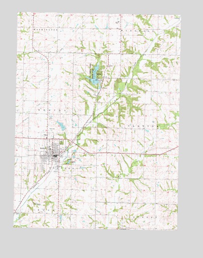
Bedford, IA USGS Topographic Map
Click on map above to begin viewing in our Map Viewer.

This topographic map contains these locations and features:
Feature Name Type Latitude Longitude GNIS ID View Map
Alegent Health ClinicHospitalN40.6675°W94.7205°1968802View Map
Baptist ChurchChurchN40.6667°W94.7247°1968807View Map
BedfordPopulated PlaceN40.6669°W94.7214°454471View Map
Bedford (historical)LocaleN40.6680°W94.7133°1968800View Map
Bedford Ambulance ServiceBuildingN40.6675°W94.7206°2599922View Map
Bedford CemeteryCemeteryN40.6603°W94.7344°454472View Map
Bedford City HallBuildingN40.6678°W94.7200°1968798View Map
Bedford City ParkParkN40.6750°W94.7141°1968854View Map
Bedford City Public LibraryBuildingN40.6680°W94.7211°1968796View Map
Bedford Elementary SchoolSchoolN40.6712°W94.7232°2719752View Map
Bedford Fire DepartmentBuildingN40.6681°W94.7180°1968799View Map
Bedford Golf CourseLocaleN40.6889°W94.7225°1968851View Map
Bedford High SchoolSchoolN40.6710°W94.7232°2719815View Map
Bedford Middle SchoolSchoolN40.6708°W94.7233°1968813View Map
Bedford Municipal AirportAirportN40.6378°W94.7294°466711View Map
Bedford Nursing and Rehabilitation CenterHospitalN40.6689°W94.7258°1968803View Map
Bedford Post OfficePost OfficeN40.6675°W94.7183°1968797View Map
Bedford Water Supply DamDamN40.6825°W94.7127°463523View Map
Bedford Water Supply LakeReservoirN40.6844°W94.7147°463524View Map
City of BedfordCivilN40.6712°W94.7240°2394105View Map
Fairview CemeteryCemeteryN40.6597°W94.7294°456478View Map
Family Practice ClinicHospitalN40.6730°W94.7211°1968801View Map
Forest Grove CemeteryCemeteryN40.6252°W94.6633°456668View Map
Hamilton Memorial Lutheran ChurchChurchN40.6664°W94.7266°1968811View Map
Harmony Post Office (historical)Post OfficeN40.7042°W94.6766°1968865View Map
Kingdom Hall of Jehovahs WitnessesChurchN40.6669°W94.7214°1968812View Map
Lake Binder ParkParkN40.7147°W94.6897°465855View Map
Lake of the Three FiresReservoirN40.7086°W94.6877°1968874View Map
Lake of the Three Fires DamDamN40.7086°W94.6877°463435View Map
Lake of Three FiresLakeN40.7136°W94.6904°458177View Map
Lake of Three Fires State ParkParkN40.7167°W94.6919°463766View Map
Lexington (historical)LocaleN40.7017°W94.6752°466349View Map
Lexington CemeteryCemeteryN40.7197°W94.6811°458309View Map
Lexington Post Office (historical)Post OfficeN40.7333°W94.6822°1968859View Map
Mohler CemeteryCemeteryN40.6635°W94.7072°459162View Map
Revelation Light of Jesus Christ ChurchChurchN40.6764°W94.7252°1968810View Map
Saint Francis Hardin Medical ClinicHospitalN40.6655°W94.7183°1968804View Map
Saint Timothy Lutheran ChurchChurchN40.6736°W94.7216°1968808View Map
Seventh Day Adventist ChurchChurchN40.6733°W94.7216°1968809View Map
Simmons Tract ParkParkN40.7305°W94.6864°1968814View Map
Taylor CountyCivilN40.7374°W94.6964°465275View Map
Taylor County CourthouseBuildingN40.6683°W94.7200°1968853View Map
Taylor County FairgroundsLocaleN40.6583°W94.7169°1968852View Map
Taylor County Farm CemeteryCemeteryN40.7417°W94.6727°1968888View Map
Taylor County Historical MuseumBuildingN40.6669°W94.7214°1968794View Map
Taylor County HomeHospitalN40.7453°W94.6727°1822846View Map
Taylor County Sheriff's OfficeBuildingN40.6677°W94.7193°1968795View Map
Township of BedfordCivilN40.6682°W94.7148°467429View Map
Township of ClaytonCivilN40.6835°W94.6367°467614View Map
United Christian Presbyterian ChurchChurchN40.6686°W94.7211°1968806View Map
United Methodist ChurchChurchN40.6692°W94.7211°1968805View Map

Note: Coordinates in the location and feature list above are referenced to NAD83 datum.


Copyright (C) 2008-2025 Ryan Niemi / Sunset Dynamics ... All Rights Reserved