TopoQuest Logo
Do you find TopoQuest useful?
Help keep TopoQuest running and adding new maps/features by donating!
Bitcoin:  19c7KJd3qBynnjoSw5npx9KScwjBe4ifkT
Litecoin:  LXs6TkuXGGXo1vDsWCkWVdjQX94eUKd6ui
Home View Maps Find Maps Find Places Resources & Links


Moontown, Alabama Topographic Map

USGS Map Title: Moontown, AL
USGS Map MRC: 34086F4
DRG (GeoTIFF) Download: o34086f4.tif


Neighboring USGS Topographic Map Quads:


  Meridianville, AL  
34086G5
 

  Maysville, AL  
34086G4
 

  Hollytree, AL  
34086G3
 

  Huntsville, AL  
34086F5
 

  Moontown, AL  
34086F4
 

  Paint Rock, AL  
34086F3
 

  Farley, AL  
34086E5
 

  New Hope, AL  
34086E4
 

  Grant, AL  
34086E3


Map MRC Location:

N35°
W87°
N35°
W86°
H8 H7 H6 H5 H4 H3 H2 H1
G8 G7 G6 G5 G4 G3 G2 G1
F8 F7 F6 F5 F4 F3 F2 F1
E8 E7 E6 E5 E4 E3 E2 E1
D8 D7 D6 D5 D4 D3 D2 D1
C8 C7 C6 C5 C4 C3 C2 C1
B8 B7 B6 B5 B4 B3 B2 B1
A8 A7 A6 A5 A4 A3 A2 A1
N34°
W87°
N34°
W86°

Moontown, AL USGS 1:24K Topographic Map Preview:
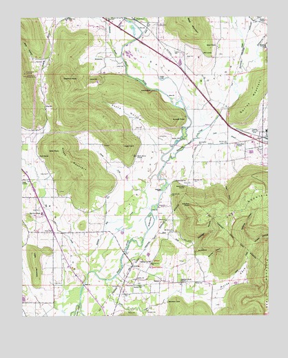
Moontown, AL USGS Topographic Map
Click on map above to begin viewing in our Map Viewer.

This topographic map contains these locations and features:
Feature Name Type Latitude Longitude GNIS ID View Map
Acklin ChurchChurchN34.6406°W86.4417°112904View Map
Adair FordCrossingN34.6709°W86.4311°155976View Map
Allison CemeteryCemeteryN34.6295°W86.4016°146652View Map
Beason CemeteryCemeteryN34.6645°W86.4272°113702View Map
Beason SpringSpringN34.7382°W86.3760°113703View Map
Beech Grove ChurchChurchN34.6918°W86.4417°113818View Map
BerkleyPopulated PlaceN34.6398°W86.4292°113946View Map
Berkley Center Head Start SchoolSchoolN34.6348°W86.4430°146682View Map
Berkley Junior High SchoolSchoolN34.6379°W86.4430°113949View Map
Big CovePopulated PlaceN34.6673°W86.4889°146693View Map
Big Cove CemeteryCemeteryN34.6451°W86.4678°146694View Map
Big Cove CreekStreamN34.6434°W86.4661°114253View Map
Big Cove Junior High SchoolSchoolN34.6681°W86.4900°114255View Map
Big Cove Presbyterian ChurchChurchN34.6826°W86.4989°146696View Map
Big Cove Volunteer Fire DepartmentBuildingN34.6605°W86.4900°2682807View Map
Blair CemeteryCemeteryN34.7345°W86.3994°1700608View Map
Blair PointCapeN34.7381°W86.4064°114468View Map
Blair SpringSpringN34.7348°W86.4077°114470View Map
Boles Point ChurchChurchN34.6793°W86.4172°114687View Map
Brazelton CemeteryCemeteryN34.6270°W86.4366°114857View Map
BrownsboroPopulated PlaceN34.7493°W86.4430°115022View Map
Brownsboro Post OfficePost OfficeN34.7473°W86.4505°2788930View Map
Buck DitchStreamN34.6598°W86.4367°115127View Map
Buffalo IslandIslandN34.6645°W86.4358°115157View Map
Camp GroundLocaleN34.6823°W86.4997°115462View Map
CandlestandSummitN34.6529°W86.4108°115531View Map
Chandler HollowValleyN34.6475°W86.4051°115939View Map
CherrytreePopulated PlaceN34.6456°W86.4444°156173View Map
Chestnut Grove Methodist ChurchChurchN34.6395°W86.4197°116022View Map
Chestnut Grove School (historical)SchoolN34.6395°W86.4194°1700609View Map
Chestnut KnobSummitN34.7243°W86.4789°116024View Map
Chigger Ridge FarmLocaleN34.6711°W86.4281°2611162View Map
Cobb Bridge (historical)BridgeN34.6451°W86.4494°146805View Map
Cobb CemeteryCemeteryN34.6484°W86.4444°146806View Map
Collier CemeteryCemeteryN34.6392°W86.4122°116431View Map
Collier LakeLakeN34.7238°W86.4280°116436View Map
Drake CemeteryCemeteryN34.6848°W86.4869°117457View Map
Drake MountainSummitN34.6876°W86.4722°117461View Map
Drake SpringSpringN34.6920°W86.4911°117464View Map
Dug HillPopulated PlaceN34.7134°W86.4878°117639View Map
Dunkin CemeteryCemeteryN34.6754°W86.4774°2082270View Map
Ebenezer Missionary Baptist ChurchChurchN34.6465°W86.4758°146862View Map
Echols CemeteryCemeteryN34.6812°W86.4150°117846View Map
Esslinger HollowValleyN34.6537°W86.4148°118034View Map
Esslinger IslandIslandN34.6790°W86.4272°118035View Map
Esslinger SpringSpringN34.6479°W86.4347°118036View Map
Fleming CemeteryCemeteryN34.6373°W86.4505°118413View Map
Frerichs AirportAirportN34.6514°W86.4133°2676315View Map
Ginn PointSummitN34.6937°W86.4803°119005View Map
Goose CreekStreamN34.6404°W86.4583°119159View Map
Grayson FordCrossingN34.6812°W86.4264°1700610View Map
Grayson PointCapeN34.6709°W86.4136°119307View Map
Grayson SpringSpringN34.6816°W86.4221°119309View Map
GurleyPopulated PlaceN34.7018°W86.3758°119509View Map
Gurley Airport (historical)AirportN34.7001°W86.3833°129506View Map
Gurley DivisionCivilN34.6762°W86.4339°165865View Map
Gurley MountainSummitN34.7098°W86.3869°119513View Map
Gurley Post OfficePost OfficeN34.6993°W86.3810°166713View Map
Hayes CemeteryCemeteryN34.6390°W86.4805°119883View Map
Hayes Chapel School (historical)SchoolN34.6459°W86.4755°1700611View Map
High PointSummitN34.6965°W86.4478°120062View Map
Hines CemeteryCemeteryN34.6379°W86.4472°120146View Map
Horse CoveValleyN34.6338°W86.4101°120403View Map
Huntsville Fire and Rescue Station 17BuildingN34.6608°W86.4759°2683122View Map
Hurricane CreekStreamN34.6893°W86.4267°151836View Map
Jenkins CemeteryCemeteryN34.7001°W86.4303°120845View Map
Killingsworth CoveValleyN34.7306°W86.3844°121193View Map
Killingsworth Cove BranchStreamN34.7295°W86.3878°121194View Map
Killingsworth Cove Volunteer Fire Department Station 2BuildingN34.7486°W86.3810°2683410View Map
King CemeteryCemeteryN34.6693°W86.4911°121214View Map
King CemeteryCemeteryN34.7315°W86.4928°121216View Map
Lawler CemeteryCemeteryN34.7465°W86.4303°121427View Map
Liberty Primitive Baptist ChurchChurchN34.6379°W86.4417°152049View Map
LickskilletBasinN34.7240°W86.4611°121602View Map
Little CoveValleyN34.6523°W86.4630°121743View Map
Little MountainSummitN34.6509°W86.4942°121821View Map
Madison County High SchoolSchoolN34.7023°W86.3755°147076View Map
Mills HollowValleyN34.7331°W86.4878°122849View Map
MoontownPopulated PlaceN34.7334°W86.4569°156731View Map
Moontown AirportAirportN34.7467°W86.4631°129510View Map
Negro HollowValleyN34.6812°W86.3969°123682View Map
Nelson ChapelChurchN34.7495°W86.3786°152596View Map
Nunn StoreLocaleN34.6601°W86.4842°124044View Map
Parker CemeteryCemeteryN34.6270°W86.4461°124443View Map
Peevey CreekStreamN34.6768°W86.4378°124569View Map
Pelletier HollowValleyN34.6597°W86.3871°124578View Map
Pickens CemeteryCemeteryN34.6752°W86.4961°2096921View Map
Potts CemeteryCemeteryN34.7034°W86.4422°125212View Map
Potts HollowValleyN34.6951°W86.4308°125215View Map
Reagan School (historical)SchoolN34.7268°W86.4122°1700615View Map
Reed MountainSummitN34.7495°W86.4164°125513View Map
Robinson Mill CreekGutN34.6656°W86.4503°125731View Map
Ross Chapel (historical)ChurchN34.6895°W86.4097°1700616View Map
Salty BottomBendN34.7234°W86.4133°126277View Map
Sand BranchStreamN34.6993°W86.4103°126303View Map
Sanford CemeteryCemeteryN34.7359°W86.4219°150019View Map
Section BranchStreamN34.7434°W86.4380°126523View Map
Shiloh Church (historical)ChurchN34.6334°W86.4033°147265View Map
Shipp Park ChurchChurchN34.6968°W86.3911°153433View Map
Sublett BluffCliffN34.7198°W86.4355°127489View Map
Sublett CemeteryCemeteryN34.7295°W86.4475°127490View Map
Sublett MillPopulated PlaceN34.6990°W86.4186°157122View Map
Sublett PointCapeN34.7065°W86.4239°127493View Map
Town of GurleyCivilN34.7076°W86.3861°2406631View Map
Vinson CemeteryCemeteryN34.7329°W86.4153°128469View Map
Vinson HollowValleyN34.6543°W86.3830°128470View Map
Wilson Reservation (historical)CivilN34.6456°W86.4353°129095View Map
Wood Airport (historical)AirportN34.7262°W86.4055°129509View Map
Wright CemeteryCemeteryN34.6479°W86.4197°147394View Map

Note: Coordinates in the location and feature list above are referenced to NAD83 datum.


Copyright (C) 2008-2024 Ryan Niemi / Sunset Dynamics ... All Rights Reserved