TopoQuest Logo
Do you find TopoQuest useful?
Help keep TopoQuest running and adding new maps/features by donating!
Bitcoin:  19c7KJd3qBynnjoSw5npx9KScwjBe4ifkT
Litecoin:  LXs6TkuXGGXo1vDsWCkWVdjQX94eUKd6ui
Home View Maps Find Maps Find Places Resources & Links


Moreland, Idaho Topographic Map

USGS Map Title: Moreland, ID
USGS Map MRC: 43112B4
DRG (GeoTIFF) Download: o43112b4.tif


Neighboring USGS Topographic Map Quads:


  Olsen, ID  
43112C5
 

  Baldy Knoll, ID  
43112C4
 

  Rose, ID  
43112C3
 

  Rockford, ID  
43112B5
 

  Moreland, ID  
43112B4
 

  Blackfoot, ID  
43112B3
 

  Pingree, ID  
43112A5
 

  Fort Hall, ID  
43112A4
 

  Buckskin Basin, ID  
43112A3


Map MRC Location:

N44°
W113°
N44°
W112°
H8 H7 H6 H5 H4 H3 H2 H1
G8 G7 G6 G5 G4 G3 G2 G1
F8 F7 F6 F5 F4 F3 F2 F1
E8 E7 E6 E5 E4 E3 E2 E1
D8 D7 D6 D5 D4 D3 D2 D1
C8 C7 C6 C5 C4 C3 C2 C1
B8 B7 B6 B5 B4 B3 B2 B1
A8 A7 A6 A5 A4 A3 A2 A1
N43°
W113°
N43°
W112°

Moreland, ID USGS 1:24K Topographic Map Preview:
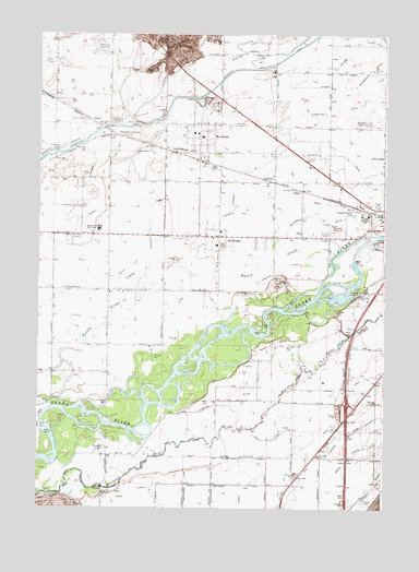
Moreland, ID USGS Topographic Map
Click on map above to begin viewing in our Map Viewer.

This topographic map contains these locations and features:
Feature Name Type Latitude Longitude GNIS ID View Map
Aberdeen JunctionPopulated PlaceN43.2230°W112.4708°397360View Map
Ace LateralCanalN43.1566°W112.3986°371190View Map
AikenPopulated PlaceN43.2091°W112.4066°396029View Map
Arch LateralCanalN43.1594°W112.3819°397386View Map
Augustine DitchCanalN43.2302°W112.3922°371309View Map
Bingham CountyCivilN43.2166°W112.3981°400593View Map
Bow LateralCanalN43.1674°W112.3791°371654View Map
Cash LateralCanalN43.1432°W112.4150°371904View Map
Central DitchCanalN43.1685°W112.4147°375785View Map
ClarksonPopulated PlaceN43.2116°W112.4186°396294View Map
CollinsPopulated PlaceN43.2021°W112.3758°396320View Map
Cooley LateralCanalN43.1385°W112.4389°372115View Map
Crawford DitchCanalN43.1694°W112.4558°372250View Map
Danskin CanalCanalN43.2185°W112.4044°372313View Map
Dubois LateralCanalN43.2499°W112.3811°375545View Map
Dubois LateralCanalN43.2399°W112.3953°372498View Map
Duncan DitchCanalN43.1805°W112.4755°372514View Map
Ebony LateralCanalN43.1394°W112.3864°372583View Map
England LateralCanalN43.2449°W112.4264°372623View Map
Flood ChannelCanalN43.1647°W112.4541°2439572View Map
Gibson CemeteryCemeteryN43.1268°W112.3831°372841View Map
Groveland CemeteryCemeteryN43.2269°W112.3818°372939View Map
Groveland Census Designated PlaceCensusN43.2235°W112.3755°2585572View Map
Lindsey LateralCanalN43.2082°W112.4789°373598View Map
Littlejohn LateralCanalN43.1385°W112.4211°373692View Map
MorelandPopulated PlaceN43.2227°W112.4425°396925View Map
Moreland CemeteryCemeteryN43.2272°W112.4697°374023View Map
Moreland Census Designated PlaceCensusN43.2195°W112.4378°2585577View Map
Moreland DivisionCivilN43.1745°W112.4760°1936764View Map
Moreland Elementary SchoolSchoolN43.2238°W112.4447°401589View Map
Moreland Post OfficePost OfficeN43.2231°W112.4426°2767291View Map
Nadir LateralCanalN43.1288°W112.4666°374096View Map
Nectar LateralCanalN43.1302°W112.4105°374106View Map
Nile LateralCanalN43.1382°W112.4000°374150View Map
Nomad LateralCanalN43.1305°W112.4269°374163View Map
North CanalCanalN43.1391°W112.4075°374173View Map
Peoples CanalCanalN43.2438°W112.4419°374362View Map
Peterson (historical)Populated PlaceN43.2399°W112.3761°376053View Map
RiversidePopulated PlaceN43.1969°W112.4353°374693View Map
Riverside Census Designated PlaceCensusN43.1966°W112.4356°2585584View Map
Riverside Elementary SchoolSchoolN43.1944°W112.4361°401136View Map
Riverton Access AreaLocaleN43.1477°W112.4591°401134View Map
Riverton DitchCanalN43.1549°W112.4294°374697View Map
RousePopulated PlaceN43.2266°W112.4791°376179View Map
Russell W Anderson StripAirportN43.1841°W112.4671°400914View Map
SNAKE RIVER HIGH SCHOOLSchoolN43.1992°W112.4805°401188View Map
Snake River High School (historical)SchoolN43.1985°W112.4783°400682View Map
Snake River Junior High SchoolSchoolN43.1982°W112.4786°401187View Map
Southtown DitchCanalN43.2191°W112.4458°375181View Map
Stevens DitchCanalN43.1717°W112.3882°2439069View Map
Thomas Riverside CemeteryCemeteryN43.1958°W112.4835°375490View Map
Townsite LateralCanalN43.2046°W112.4300°375559View Map
Wearyrick DitchCanalN43.1952°W112.4458°375775View Map

Note: Coordinates in the location and feature list above are referenced to NAD83 datum.


Copyright (C) 2008-2025 Ryan Niemi / Sunset Dynamics ... All Rights Reserved