TopoQuest Logo
Do you find TopoQuest useful?
Help keep TopoQuest running and adding new maps/features by donating!
Bitcoin:  19c7KJd3qBynnjoSw5npx9KScwjBe4ifkT
Litecoin:  LXs6TkuXGGXo1vDsWCkWVdjQX94eUKd6ui
Home View Maps Find Maps Find Places Resources & Links


Morgantown, Kentucky Topographic Map

USGS Map Title: Morgantown, KY
USGS Map MRC: 37086B6
DRG (GeoTIFF) Download: o37086b6.tif


Neighboring USGS Topographic Map Quads:


  Cromwell, KY  
37086C7
 

  Flener, KY  
37086C6
 

  Welchs Creek, KY  
37086C5
 

  South Hill, KY  
37086B7
 

  Morgantown, KY  
37086B6
 

  Riverside, KY  
37086B5
 

  Quality, KY  
37086A7
 

  Sugar Grove, KY  
37086A6
 

  Hadley, KY  
37086A5


Map MRC Location:

N38°
W87°
N38°
W86°
H8 H7 H6 H5 H4 H3 H2 H1
G8 G7 G6 G5 G4 G3 G2 G1
F8 F7 F6 F5 F4 F3 F2 F1
E8 E7 E6 E5 E4 E3 E2 E1
D8 D7 D6 D5 D4 D3 D2 D1
C8 C7 C6 C5 C4 C3 C2 C1
B8 B7 B6 B5 B4 B3 B2 B1
A8 A7 A6 A5 A4 A3 A2 A1
N37°
W87°
N37°
W86°

Morgantown, KY USGS 1:24K Topographic Map Preview:
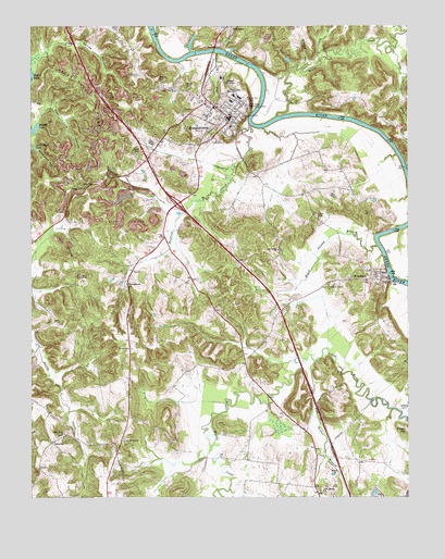
Morgantown, KY USGS Topographic Map
Click on map above to begin viewing in our Map Viewer.

This topographic map contains these locations and features:
Feature Name Type Latitude Longitude GNIS ID View Map
Allens HillSummitN37.2359°W86.7083°485876View Map
Big BranchStreamN37.2428°W86.6878°487098View Map
Black Swamp BranchStreamN37.1917°W86.6350°487391View Map
Butler CountyCivilN37.2073°W86.6818°516862View Map
Butler County Ambulance ServiceBuildingN37.2252°W86.6821°2719119View Map
Butler County Sheriff's OfficeBuildingN37.2254°W86.6829°2767456View Map
Carved Rock (historical)Populated PlaceN37.1407°W86.7200°2742326View Map
Carved Rock ChurchChurchN37.1400°W86.7189°489033View Map
City of MorgantownCivilN37.2173°W86.7001°2404305View Map
City of WoodburyCivilN37.1835°W86.6354°2405780View Map
Clifty BranchStreamN37.2414°W86.6544°489679View Map
Cook CemeteryCemeteryN37.1995°W86.6553°490001View Map
Cool Spring ChurchChurchN37.1906°W86.6683°490019View Map
Cools Spring (historical)Populated PlaceN37.1902°W86.6679°2742328View Map
Deer Lick HollowValleyN37.2290°W86.7440°490778View Map
Hagan Shanty RidgeRidgeN37.2306°W86.7292°493537View Map
Hill Haven Memory GardensCemeteryN37.2287°W86.6775°494251View Map
Hocker BranchStreamN37.1615°W86.6554°494328View Map
LeetownPopulated PlaceN37.1395°W86.7428°508440View Map
Little Bluff LakeReservoirN37.2180°W86.7487°496633View Map
Little Muddy ChurchChurchN37.1264°W86.6536°496813View Map
Lock Dam Number 4DamN37.1834°W86.6314°517216View Map
Long BranchStreamN37.2434°W86.6303°497068View Map
Long Branch (historical)Populated PlaceN37.2334°W86.6273°2742336View Map
Lower HollowValleyN37.2406°W86.6642°497284View Map
Middle HollowValleyN37.2400°W86.6589°498142View Map
Middle LakeLakeN37.2236°W86.7483°498145View Map
Mooretown (historical)Populated PlaceN37.2054°W86.6595°2742342View Map
MorgantownPopulated PlaceN37.2256°W86.6836°498600View Map
Morgantown DivisionCivilN37.2252°W86.7320°1937154View Map
Morgantown Fire DepartmentBuildingN37.2251°W86.6822°2636349View Map
Morgantown Police DepartmentBuildingN37.2216°W86.6896°2767614View Map
Newton CemeteryCemeteryN37.1814°W86.6489°499452View Map
Pipe Spring HollowValleyN37.2431°W86.7463°500756View Map
Pleasant Rock ChurchChurchN37.2073°W86.7317°500903View Map
Possum HollowValleyN37.2371°W86.6252°2742346View Map
Renfrow CreekStreamN37.2237°W86.6769°501727View Map
Riverside CemeteryCemeteryN37.2300°W86.6783°501986View Map
Sandy Creek ChurchChurchN37.1420°W86.7389°502980View Map
Stillhouse HollowValleyN37.2185°W86.7497°504418View Map
Wade CemeteryCemeteryN37.2162°W86.7147°506089View Map
Welch CreekStreamN37.2262°W86.6683°506362View Map
WLBQ-AM (Morgantown)TowerN37.2362°W86.7080°517867View Map
WoodburyPopulated PlaceN37.1834°W86.6339°507088View Map
YoungtownPopulated PlaceN37.1814°W86.7186°509423View Map

Note: Coordinates in the location and feature list above are referenced to NAD83 datum.


Copyright (C) 2008-2024 Ryan Niemi / Sunset Dynamics ... All Rights Reserved