TopoQuest Logo
Do you find TopoQuest useful?
Help keep TopoQuest running and adding new maps/features by donating!
Bitcoin:  19c7KJd3qBynnjoSw5npx9KScwjBe4ifkT
Litecoin:  LXs6TkuXGGXo1vDsWCkWVdjQX94eUKd6ui
Home View Maps Find Maps Find Places Resources & Links


Morocco, Indiana Topographic Map

USGS Map Title: Morocco, IN
USGS Map MRC: 40087H4
DRG (GeoTIFF) Download: o40087h4.tif


Neighboring USGS Topographic Map Quads:


  Leesville, IL  
41087A5
 

  Enos, IN  
41087A4
 

  Fair Oaks, IN  
41087A3
 

  Donovan, IL  
40087H5
 

  Morocco, IN  
40087H4
 

  Mount Ayr, IN  
40087H3
 

  Sheldon, IL  
40087G5
 

  Kentland, IN  
40087G4
 

  Goodland, IN  
40087G3


Map MRC Location:

N41°
W88°
N41°
W87°
H8 H7 H6 H5 H4 H3 H2 H1
G8 G7 G6 G5 G4 G3 G2 G1
F8 F7 F6 F5 F4 F3 F2 F1
E8 E7 E6 E5 E4 E3 E2 E1
D8 D7 D6 D5 D4 D3 D2 D1
C8 C7 C6 C5 C4 C3 C2 C1
B8 B7 B6 B5 B4 B3 B2 B1
A8 A7 A6 A5 A4 A3 A2 A1
N40°
W88°
N40°
W87°

Morocco, IN USGS 1:24K Topographic Map Preview:
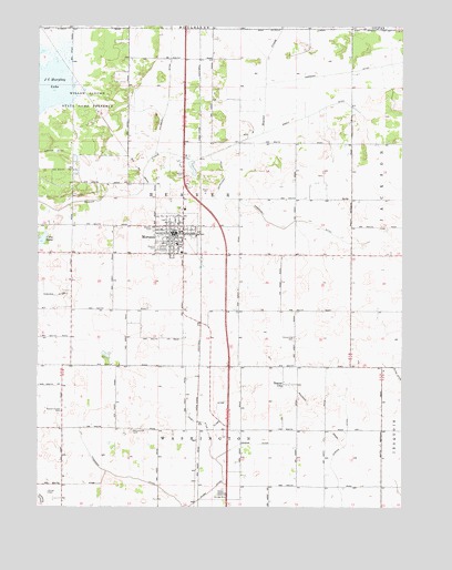
Morocco, IN USGS Topographic Map
Click on map above to begin viewing in our Map Viewer.

This topographic map contains these locations and features:
Feature Name Type Latitude Longitude GNIS ID View Map
Beaver CityPopulated PlaceN40.9070°W87.4156°430671View Map
Beaver City CemeteryCemeteryN40.9191°W87.4120°430672View Map
Chizum DitchCanalN40.8914°W87.4281°432485View Map
Clark DitchCanalN40.8950°W87.4417°432560View Map
Cory LakeLakeN40.9445°W87.4986°433001View Map
Deardurff DitchCanalN40.9586°W87.4375°433394View Map
Garrard DitchCanalN40.8756°W87.4981°434968View Map
Lawler DitchCanalN40.9673°W87.4984°437661View Map
MoroccoPopulated PlaceN40.9461°W87.4534°439442View Map
Morocco Elementary SchoolSchoolN40.9434°W87.4528°447322View Map
Morocco Police DepartmentBuildingN40.9468°W87.4537°2758199View Map
Morocco Volunteer Fire DepartmentBuildingN40.9423°W87.4495°2626326View Map
Murphy CemeteryCemeteryN40.9425°W87.4588°439891View Map
Narrows DitchCanalN40.9881°W87.3978°439939View Map
Newton CountyCivilN40.9558°W87.3975°450376View Map
Newton County Emergency Medical Services - South BaseBuildingN40.8767°W87.4335°2719343View Map
Oakland CemeteryCemeteryN40.9618°W87.4514°440466View Map
Porter CemeteryCemeteryN40.8792°W87.4962°441463View Map
Prairie Vine CemeteryCemeteryN40.8949°W87.4676°441562View Map
Russell Chapel CemeteryCemeteryN40.9002°W87.4917°442414View Map
Sheep DitchCanalN40.9800°W87.3995°443334View Map
Shuey DitchCanalN40.8973°W87.4442°443463View Map
Town of MoroccoCivilN40.9445°W87.4503°2396782View Map
Township of BeaverCivilN40.9556°W87.4593°453102View Map
Zaborosky DitchCanalN40.9498°W87.4117°446422View Map

Note: Coordinates in the location and feature list above are referenced to NAD83 datum.


Copyright (C) 2008-2025 Ryan Niemi / Sunset Dynamics ... All Rights Reserved