TopoQuest Logo
Do you find TopoQuest useful?
Help keep TopoQuest running and adding new maps/features by donating!
Bitcoin:  19c7KJd3qBynnjoSw5npx9KScwjBe4ifkT
Litecoin:  LXs6TkuXGGXo1vDsWCkWVdjQX94eUKd6ui
Home View Maps Find Maps Find Places Resources & Links


Moses Lake South, Washington Topographic Map

USGS Map Title: Moses Lake South, WA
USGS Map MRC: 47119A3
DRG (GeoTIFF) Download: o47119a3.tif


Neighboring USGS Topographic Map Quads:


  Moses Lake NW, WA  
47119B4
 

  Moses Lake North, WA  
47119B3
 

  Wheeler, WA  
47119B2
 

  Mae, WA  
47119A4
 

  Moses Lake South, WA  
47119A3
 

  Sieler, WA  
47119A2
 

  Royal Camp, WA  
46119H4
 

  O'Sullivan Dam, WA  
46119H3
 

  Soda Lake, WA  
46119H2


Map MRC Location:

N48°
W120°
N48°
W119°
H8 H7 H6 H5 H4 H3 H2 H1
G8 G7 G6 G5 G4 G3 G2 G1
F8 F7 F6 F5 F4 F3 F2 F1
E8 E7 E6 E5 E4 E3 E2 E1
D8 D7 D6 D5 D4 D3 D2 D1
C8 C7 C6 C5 C4 C3 C2 C1
B8 B7 B6 B5 B4 B3 B2 B1
A8 A7 A6 A5 A4 A3 A2 A1
N47°
W120°
N47°
W119°

Moses Lake South, WA USGS 1:24K Topographic Map Preview:
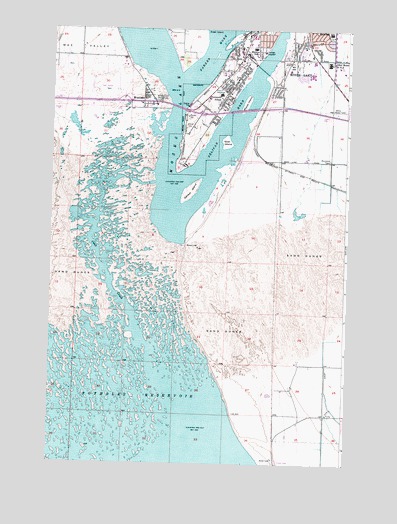
Moses Lake South, WA USGS Topographic Map
Click on map above to begin viewing in our Map Viewer.

This topographic map contains these locations and features:
Feature Name Type Latitude Longitude GNIS ID View Map
Chief Moses Middle SchoolSchoolN47.1153°W119.2590°1503958View Map
Crab CreekStreamN47.0193°W119.3220°1504239View Map
Gaileys IslandIslandN47.0782°W119.3170°1505072View Map
Garden Heights Elementary SchoolSchoolN47.1158°W119.2654°1514979View Map
Goat IslandIslandN47.0924°W119.3020°1505155View Map
Grant County Fire District 5 Station 1 HeadquartersBuildingN47.1169°W119.2560°2643566View Map
Grant County Fire District 5 Station 12BuildingN47.0876°W119.2782°2643567View Map
Grant County Fire District 5 Station 2BuildingN47.1172°W119.3628°2643568View Map
KBSN-AM (Moses Lake)TowerN47.1043°W119.2934°1534269View Map
KBSN-FM (Moses Lake)TowerN47.0982°W119.2975°1534358View Map
Lakeview Terrace Elementary SchoolSchoolN47.1240°W119.2584°1530963View Map
Marsh IslandIslandN47.1043°W119.2936°1506476View Map
Midway Elementary SchoolSchoolN47.1197°W119.2904°1531021View Map
Moses Lake Fire Department Station 2BuildingN47.1078°W119.3060°2619643View Map
Moses Lake High SchoolSchoolN47.1118°W119.2653°1514977View Map
Moses Lake North DamDamN47.0849°W119.3328°1532103View Map
Moses Lake South DamDamN47.0801°W119.3342°1532102View Map
Moses Lake State ParkParkN47.1043°W119.3297°1506805View Map
No-Outlet Sand HillsAreaN47.0499°W119.2817°1514643View Map
Parker HornBayN47.1178°W119.3082°1507307View Map
Pelican HornBayN47.0952°W119.3009°1507359View Map
Peninsula Elementary SchoolSchoolN47.1062°W119.3042°1531063View Map
Potholes Habitat Management AreaParkN47.0199°W119.3734°1510578View Map
Potholes ReservoirReservoirN47.0126°W119.3436°1513187View Map
WestlakePopulated PlaceN47.1040°W119.3367°1512799View Map

Note: Coordinates in the location and feature list above are referenced to NAD83 datum.


Copyright (C) 2008-2025 Ryan Niemi / Sunset Dynamics ... All Rights Reserved