TopoQuest Logo
Do you find TopoQuest useful?
Help keep TopoQuest running and adding new maps/features by donating!
Bitcoin:  19c7KJd3qBynnjoSw5npx9KScwjBe4ifkT
Litecoin:  LXs6TkuXGGXo1vDsWCkWVdjQX94eUKd6ui
Home View Maps Find Maps Find Places Resources & Links


Mount Carmel, Alabama Topographic Map

USGS Map Title: Mount Carmel, AL
USGS Map MRC: 34086D3
DRG (GeoTIFF) Download: o34086d3.tif


Neighboring USGS Topographic Map Quads:


  New Hope, AL  
34086E4
 

  Grant, AL  
34086E3
 

  Swearengin, AL  
34086E2
 

  Guntersville Dam, AL  
34086D4
 

  Mount Carmel, AL  
34086D3
 

  Columbus City, AL  
34086D2
 

  Arab, AL  
34086C4
 

  Guntersville, AL  
34086C3
 

  Albertville, AL  
34086C2


Map MRC Location:

N35°
W87°
N35°
W86°
H8 H7 H6 H5 H4 H3 H2 H1
G8 G7 G6 G5 G4 G3 G2 G1
F8 F7 F6 F5 F4 F3 F2 F1
E8 E7 E6 E5 E4 E3 E2 E1
D8 D7 D6 D5 D4 D3 D2 D1
C8 C7 C6 C5 C4 C3 C2 C1
B8 B7 B6 B5 B4 B3 B2 B1
A8 A7 A6 A5 A4 A3 A2 A1
N34°
W87°
N34°
W86°

Mount Carmel, AL USGS 1:24K Topographic Map Preview:
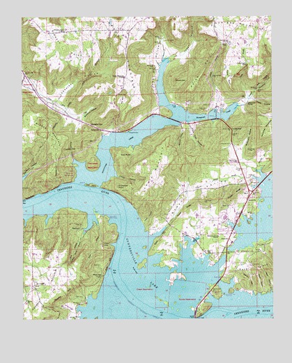
Mount Carmel, AL USGS Topographic Map
Click on map above to begin viewing in our Map Viewer.

This topographic map contains these locations and features:
Feature Name Type Latitude Longitude GNIS ID View Map
Abel CemeteryCemeteryN34.4281°W86.3255°112889View Map
Adams Street Baptist ChurchChurchN34.3754°W86.3011°147679View Map
Alred MarinaLocaleN34.3968°W86.2816°139325View Map
Baker ChapelChurchN34.4090°W86.2841°139329View Map
Baker HillSummitN34.4076°W86.3064°113386View Map
Beards BarBarN34.3848°W86.3222°139333View Map
Beards ReefBarN34.3918°W86.3283°139334View Map
Bethel ChurchChurchN34.3829°W86.3730°114079View Map
Birmingham YMCA CampLocaleN34.4179°W86.3642°148856View Map
Bishop MountainSummitN34.4593°W86.3703°114386View Map
Black GapGapN34.3931°W86.3355°114423View Map
Browns BarBarN34.4009°W86.3278°139352View Map
Buck IslandIslandN34.3981°W86.2522°115131View Map
Buck Island ShoresPopulated PlaceN34.3920°W86.2725°1729863View Map
Buck Island SubdivisionPopulated PlaceN34.3865°W86.2714°148852View Map
Bullocks HollowValleyN34.4590°W86.3450°115196View Map
Cane Tuck HollowValleyN34.4551°W86.2911°115555View Map
Caney HollowValleyN34.4343°W86.3283°115578View Map
Cha-La-Kee YMCA CampLocaleN34.4154°W86.3328°154182View Map
Cheek Reservation (historical)CivilN34.3881°W86.3153°115987View Map
Chestnut FlatFlatN34.4445°W86.2605°116018View Map
ClaysvillePopulated PlaceN34.4079°W86.2719°156187View Map
Claysville ChurchChurchN34.4031°W86.2833°148855View Map
Claysville Junior High SchoolSchoolN34.4068°W86.2703°139360View Map
Cochrane CemeteryCemeteryN34.4904°W86.3036°116338View Map
Cooley CemeteryCemeteryN34.4143°W86.3453°116548View Map
CottonvillePopulated PlaceN34.4534°W86.3355°156219View Map
Cottonville School (historical)SchoolN34.4512°W86.3355°1729864View Map
CushionPopulated PlaceN34.4759°W86.3708°139368View Map
Cushion SpringSpringN34.4751°W86.3709°149235View Map
Deposit Landing (historical)LocaleN34.4290°W86.3353°139371View Map
Dripping Spring BranchStreamN34.4109°W86.3447°117479View Map
Fishers HollowValleyN34.4056°W86.3294°118318View Map
Fishing HollowValleyN34.4126°W86.3439°1729865View Map
Fort Deposit (historical)Populated PlaceN34.4340°W86.3333°139381View Map
Fort Deposit Ferry (historical)CrossingN34.4290°W86.3361°139382View Map
Fort Deposit PointSummitN34.4298°W86.3275°118473View Map
Fulks PointCapeN34.4759°W86.2850°118741View Map
Georgia Mountain Volunteer Fire Department Station 1BuildingN34.3888°W86.3708°2682776View Map
Goat IslandIslandN34.4304°W86.3408°119071View Map
Grant DivisionCivilN34.4949°W86.2792°165887View Map
Grassy MountainSummitN34.4998°W86.3353°119250View Map
Grassy Mountain ChurchChurchN34.4754°W86.3239°119251View Map
Gunter Reservation (historical)CivilN34.3837°W86.2939°119504View Map
Guntersville Lake Yacht ClubLocaleN34.3851°W86.2744°164339View Map
Guntersville Municipal Airport - Joe Starnes FieldAirportN34.3987°W86.2715°129494View Map
Hale PointCapeN34.4423°W86.3247°119560View Map
Half Acre EstatesPopulated PlaceN34.4645°W86.2797°148880View Map
Hampton Grove ChurchChurchN34.4090°W86.2772°119663View Map
Hampton Grove School (historical)SchoolN34.4098°W86.2775°1729867View Map
Hanaville ChurchChurchN34.4248°W86.2616°1729868View Map
Hardshell Baptist Church (historical)ChurchN34.3754°W86.3161°142592View Map
Hayes BranchStreamN34.4145°W86.3383°119882View Map
Hayes Branch SubdivisionPopulated PlaceN34.4140°W86.3380°148884View Map
Henry CemeteryCemeteryN34.4342°W86.2622°119973View Map
HenryvillePopulated PlaceN34.4245°W86.2622°119977View Map
Henryville CemeteryCemeteryN34.4323°W86.2603°119978View Map
Henryville ChurchChurchN34.4248°W86.2614°139399View Map
Holiday ShoresPopulated PlaceN34.4459°W86.3172°148882View Map
Holiness Church (historical)ChurchN34.4123°W86.2764°149243View Map
Honey BluffCliffN34.4256°W86.3711°120319View Map
Honey CemeteryCemeteryN34.4293°W86.3747°120321View Map
Honeycomb CemeteryCemeteryN34.4529°W86.3230°120327View Map
Honeycomb ChurchChurchN34.4534°W86.3272°139404View Map
Honeycomb Church (historical)ChurchN34.4526°W86.3219°1729870View Map
Honeycomb CreekStreamN34.4312°W86.3464°120328View Map
Honeycomb Natural BridgeArchN34.4592°W86.3289°2571542View Map
Honeycomb ParkPopulated PlaceN34.4762°W86.3092°148881View Map
Honeycomb School (historical)SchoolN34.4631°W86.2964°1729871View Map
Honeycomb Snug HarborLocaleN34.4556°W86.2958°139405View Map
Honeycomb SpringSpringN34.4643°W86.2623°120329View Map
Jagger BranchStreamN34.4606°W86.2980°148857View Map
Jagger BranchStreamN34.4815°W86.3042°1729872View Map
Jagger HollowValleyN34.4826°W86.2992°120800View Map
Jim Cryar HillSummitN34.4234°W86.2844°120890View Map
John R HollowValleyN34.4620°W86.2997°120917View Map
Johnson (historical)Populated PlaceN34.4176°W86.3014°139409View Map
Key BasinBasinN34.4662°W86.3253°121168View Map
Kirk HollowValleyN34.4156°W86.3414°121251View Map
Ledbetter HollowValleyN34.4665°W86.3564°121457View Map
Lewis MountainSummitN34.4418°W86.3042°121522View Map
Lindsey-Honeycomb Creek Wild AreaParkN34.4406°W86.3528°148862View Map
Lucas GapGapN34.4534°W86.2703°122099View Map
ManchesterPopulated PlaceN34.4112°W86.3483°156650View Map
Marshall Baptist CampLocaleN34.4815°W86.2616°154185View Map
Marshall County ParkParkN34.3804°W86.2839°122308View Map
Martin HillSummitN34.3920°W86.2630°122328View Map
McCorkle BranchStreamN34.4365°W86.2555°122493View Map
McDonald CemeteryCemeteryN34.4473°W86.2711°122523View Map
McDonald HollowValleyN34.4418°W86.2650°122525View Map
McKee Island (historical)IslandN34.3762°W86.2791°139436View Map
Missionary Church (historical)ChurchN34.4029°W86.2747°1729875View Map
Mitchell HollowValleyN34.4540°W86.2953°122904View Map
Mount CarmelPopulated PlaceN34.3893°W86.3692°152405View Map
Mount Carmel CemeteryCemeteryN34.3901°W86.3689°147482View Map
Mount Carmel ChurchChurchN34.3909°W86.3700°139440View Map
Noahs ArkSummitN34.4743°W86.2983°112865View Map
North (historical)Populated PlaceN34.4112°W86.2741°139450View Map
Panquin CemeteryCemeteryN34.4681°W86.3283°124401View Map
Pine ShoresPopulated PlaceN34.4648°W86.2992°148885View Map
Pinedale ShoresPopulated PlaceN34.4184°W86.2636°148854View Map
Piney BranchStreamN34.4656°W86.2616°124865View Map
Piney Branch FallsFallsN34.4803°W86.2624°124866View Map
Plant System Hospital Number Three (historical)HospitalN34.3768°W86.3175°142802View Map
Playground ShoresPopulated PlaceN34.4118°W86.2675°148853View Map
Powell Mill HollowValleyN34.4631°W86.2680°125228View Map
Pumpkin HollowValleyN34.4395°W86.3475°125362View Map
Ricketts GapGapN34.4554°W86.3405°125620View Map
Riverbend MarinaLocaleN34.4304°W86.2547°139474View Map
Riverview CampgroundLocaleN34.3759°W86.3436°139475View Map
Roden CemeteryCemeteryN34.4223°W86.2755°125884View Map
Roden RidgeRidgeN34.4265°W86.2683°125886View Map
Roden ValleyValleyN34.4084°W86.3105°125887View Map
Saint Peters Parish SchoolSchoolN34.3754°W86.3053°142849View Map
Seibold BranchStreamN34.4329°W86.2586°153366View Map
Shadowfax FarmLocaleN34.4958°W86.2714°2516612View Map
Shady AcresPopulated PlaceN34.4693°W86.3033°148883View Map
Simpson PointCapeN34.4870°W86.3539°126877View Map
Simpson Point ChurchChurchN34.4943°W86.3536°126878View Map
Simpson Point School (historical)SchoolN34.4923°W86.3536°139483View Map
Slater HollowValleyN34.4656°W86.2589°126958View Map
Stewart CemeteryCemeteryN34.4634°W86.2805°127383View Map
Street BluffCliffN34.3973°W86.3322°127458View Map
Street Bluff Boat DockLocaleN34.3812°W86.3433°139490View Map
Street CemeteryCemeteryN34.3843°W86.3455°127459View Map
Street CemeteryCemeteryN34.3973°W86.3364°127460View Map
Taylor CemeteryCemeteryN34.3970°W86.2608°127730View Map
Taylor HollowValleyN34.3862°W86.2508°127743View Map
Taylor RidgeRidgeN34.4198°W86.2939°127745View Map
The YLocaleN34.4270°W86.2611°127849View Map
Thompson Reservation (historical)CivilN34.4387°W86.3400°127913View Map
Thrasher BluffCliffN34.3845°W86.3547°127940View Map
Tidwell HollowValleyN34.4148°W86.3144°127968View Map
Troup CemeteryCemeteryN34.4620°W86.2830°128086View Map
Troup CemeteryCemeteryN34.4754°W86.2719°128087View Map
Troup PointCapeN34.4745°W86.2722°128089View Map
Williams MarinaLocaleN34.4040°W86.2733°139503View Map
Willis CemeteryCemeteryN34.4651°W86.2922°139504View Map
Willis HollowValleyN34.4662°W86.2766°129050View Map
Woods HollowValleyN34.3862°W86.2553°129213View Map
Word GapGapN34.4893°W86.2719°129236View Map
Yogi Bears Jellystone ParkParkN34.4168°W86.2583°154189View Map

Note: Coordinates in the location and feature list above are referenced to NAD83 datum.


Copyright (C) 2008-2024 Ryan Niemi / Sunset Dynamics ... All Rights Reserved