TopoQuest Logo
Do you find TopoQuest useful?
Help keep TopoQuest running and adding new maps/features by donating!
Bitcoin:  19c7KJd3qBynnjoSw5npx9KScwjBe4ifkT
Litecoin:  LXs6TkuXGGXo1vDsWCkWVdjQX94eUKd6ui
Home View Maps Find Maps Find Places Resources & Links


Beechgrove, Tennessee Topographic Map

USGS Map Title: Beechgrove, TN
USGS Map MRC: 35086F2
DRG (GeoTIFF) Download: o35086f2.tif


Neighboring USGS Topographic Map Quads:


  Dillton, TN  
35086G3
 

  Readyville, TN  
35086G2
 

  Woodbury, TN  
35086G1
 

  Webbs Jungle, TN  
35086F3
 

  Beechgrove, TN  
35086F2
 

  Hollow Springs, TN  
35086F1
 

  Wartrace, TN  
35086E3
 

  Noah, TN  
35086E2
 

  Fredonia, TN  
35086E1


Map MRC Location:

N36°
W87°
N36°
W86°
H8 H7 H6 H5 H4 H3 H2 H1
G8 G7 G6 G5 G4 G3 G2 G1
F8 F7 F6 F5 F4 F3 F2 F1
E8 E7 E6 E5 E4 E3 E2 E1
D8 D7 D6 D5 D4 D3 D2 D1
C8 C7 C6 C5 C4 C3 C2 C1
B8 B7 B6 B5 B4 B3 B2 B1
A8 A7 A6 A5 A4 A3 A2 A1
N35°
W87°
N35°
W86°

Beechgrove, TN USGS 1:24K Topographic Map Preview:
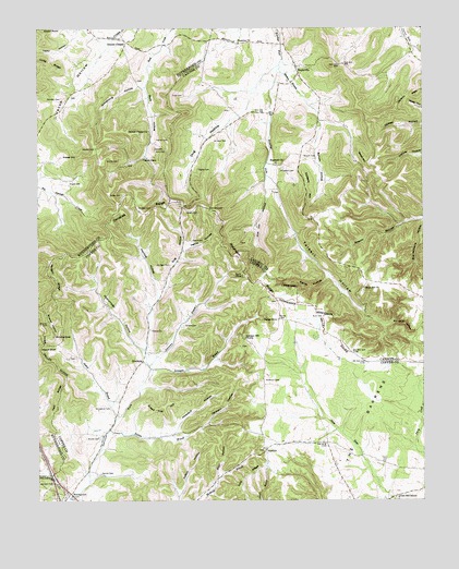
Beechgrove, TN USGS Topographic Map
Click on map above to begin viewing in our Map Viewer.

This topographic map contains these locations and features:
Feature Name Type Latitude Longitude GNIS ID View Map
Anderson CemeteryCemeteryN35.6567°W86.1767°1275699View Map
Armstrong HollowValleyN35.7347°W86.2163°1275870View Map
Arnold CemeteryCemeteryN35.6417°W86.2344°1275883View Map
Arnold CemeteryCemeteryN35.7153°W86.2236°1275884View Map
Ashley School (historical)SchoolN35.6406°W86.1575°1315937View Map
Barnes StoreLocaleN35.6731°W86.1719°1276362View Map
Bayley Mill (historical)LocaleN35.6417°W86.2292°1315940View Map
BeechgrovePopulated PlaceN35.6270°W86.2403°1269328View Map
Blair HollowValleyN35.6319°W86.1914°1277646View Map
Bowman CemeteryCemeteryN35.7315°W86.2419°1278072View Map
BradyvillePopulated PlaceN35.7398°W86.1655°1305387View Map
Bradyville Church of ChristChurchN35.7376°W86.1650°1643509View Map
Bradyville Post OfficePost OfficeN35.7390°W86.1658°1650161View Map
Bradyville School (historical)SchoolN35.7437°W86.1653°1643510View Map
Bradyville Volunteer Fire DepartmentBuildingN35.7357°W86.1703°2654971View Map
Bread Tray HillSummitN35.6495°W86.2111°1278264View Map
Brown CemeteryCemeteryN35.7062°W86.2228°1278537View Map
Broyles CemeteryCemeteryN35.6720°W86.2469°1278641View Map
Broyles HollowValleyN35.6665°W86.2438°1278646View Map
Burk CemeteryCemeteryN35.7178°W86.2117°1305538View Map
Burk CemeteryCemeteryN35.6734°W86.1575°1279046View Map
Burk HollowValleyN35.7344°W86.2154°1279047View Map
Burk School (historical)SchoolN35.7237°W86.2136°1323464View Map
Bynum CemeteryCemeteryN35.7165°W86.1636°1279238View Map
Bynum HollowValleyN35.7254°W86.1575°1279241View Map
Carson HillsSummitN35.7320°W86.1297°1279763View Map
Commissioner District 10CivilN35.6277°W86.1839°2464303View Map
Dickens HillSummitN35.7115°W86.1636°1306339View Map
Donnel ChapelChurchN35.7462°W86.2211°1306383View Map
Donnell CemeteryCemeteryN35.7442°W86.2222°1645611View Map
Donnell ChapelPopulated PlaceN35.7465°W86.2208°1647686View Map
Douglas CemeteryCemeteryN35.7020°W86.2175°1282724View Map
Douglas RidgeRidgeN35.7037°W86.2186°1282741View Map
Dug HollowValleyN35.6817°W86.2091°1283084View Map
Dug HollowValleyN35.7297°W86.1814°1283085View Map
Fort Nash (historical)LocaleN35.6884°W86.1858°1643853View Map
FudgearoundPopulated PlaceN35.6826°W86.1797°1643854View Map
Garrison Fork ChurchChurchN35.6298°W86.2442°1285216View Map
Gilley Hill CemeteryCemeteryN35.6806°W86.1444°1643551View Map
Gilley Hill ChurchChurchN35.6812°W86.1442°1285404View Map
Gilley Hill School (historical)SchoolN35.6817°W86.1444°1309962View Map
Gilly HillSummitN35.6831°W86.1450°1309961View Map
Gnat Hill SchoolSchoolN35.6259°W86.1336°1285538View Map
GossburgPopulated PlaceN35.6620°W86.2161°1315137View Map
Gossburg SchoolSchoolN35.6787°W86.2111°1285740View Map
Green CemeteryCemeteryN35.7017°W86.2017°1286077View Map
Greene CemeteryCemeteryN35.6715°W86.2028°1286158View Map
Harrell CemeteryCemeteryN35.7209°W86.2117°1286930View Map
Harrold CemeteryCemeteryN35.7184°W86.2311°1287031View Map
Harrold HollowValleyN35.6805°W86.2108°1287032View Map
Hatties Chapel ChurchChurchN35.7231°W86.2136°1287149View Map
Hettie CemeteryCemeteryN35.6940°W86.2003°1287523View Map
Hettie HollowValleyN35.6917°W86.2020°1287525View Map
HoodooPopulated PlaceN35.6384°W86.1761°1288235View Map
Hoodoo Methodist ChurchChurchN35.6390°W86.1767°1316005View Map
Hopewell (historical)Populated PlaceN35.7140°W86.1722°1643566View Map
Hopewell Baptist ChurchChurchN35.7145°W86.1725°1288309View Map
Hopewell CemeteryCemeteryN35.7123°W86.1711°1288295View Map
Hopewell School (historical)SchoolN35.7142°W86.1714°1309963View Map
Howland HollowValleyN35.6431°W86.2059°1288569View Map
Jackson HollowValleyN35.6451°W86.1949°1289225View Map
Jacob HollowValleyN35.7482°W86.2257°1289248View Map
Jacobs CemeteryCemeteryN35.7320°W86.2392°1645713View Map
Jernigan (historical)Populated PlaceN35.7262°W86.1839°1643572View Map
Jernigan BranchStreamN35.6598°W86.2139°1289394View Map
Jernigan CemeteryCemeteryN35.6876°W86.2072°1289396View Map
Jernigan CemeteryCemeteryN35.7215°W86.1900°1289397View Map
Jernigan Hill ChurchChurchN35.6681°W86.1830°1289401View Map
Jernigan School (historical)SchoolN35.7265°W86.1836°1309966View Map
Jernigans HollowValleyN35.6597°W86.2132°1643864View Map
Lakewood Park Census Designated PlaceCensusN35.6482°W86.1357°2584583View Map
Lawrence BranchStreamN35.6609°W86.2142°1290778View Map
Lee CemeteryCemeteryN35.7184°W86.2122°1290948View Map
Manley CemeteryCemeteryN35.6326°W86.2300°1292576View Map
Mason BluffCliffN35.6653°W86.2492°1292877View Map
Mill Bluff HollowValleyN35.6712°W86.1374°1293787View Map
Morgan RidgeRidgeN35.6848°W86.2447°1294377View Map
Mount Hebron Camp Ground (historical)LocaleN35.6487°W86.2264°1643873View Map
Mount Hebron CemeteryCemeteryN35.6495°W86.2267°1294624View Map
New Union Volunteer Fire Department Station 2BuildingN35.6343°W86.1365°2654959View Map
Norton BranchStreamN35.6437°W86.2269°1295981View Map
Pallette CemeteryCemeteryN35.7481°W86.1722°1643603View Map
Patton CemeteryCemeteryN35.7431°W86.1542°1643606View Map
Patton HollowValleyN35.6261°W86.2046°1296982View Map
Possumpaw BranchStreamN35.6645°W86.2153°1310325View Map
Possumpaw HollowValleyN35.6651°W86.2159°1298305View Map
Prater CemeteryCemeteryN35.7090°W86.2397°1298454View Map
Prater HillSummitN35.7162°W86.2372°1298458View Map
Ramp HollowValleyN35.6843°W86.1561°1298876View Map
Rile Hill HollowValleyN35.7079°W86.1751°1299447View Map
Robinson (historical)Populated PlaceN35.6790°W86.1728°1643887View Map
Robinson CemeteryCemeteryN35.7017°W86.1942°1299691View Map
Robinson RidgeRidgeN35.6859°W86.1814°1299715View Map
Sagely CemeteryCemeteryN35.7128°W86.1978°1300407View Map
Shelton BranchStreamN35.7392°W86.1711°1270009View Map
Sutton BranchStreamN35.6470°W86.2250°1271901View Map
Taylor CemeteryCemeteryN35.7362°W86.2175°1645957View Map
Taylor HollowValleyN35.7486°W86.2372°1272241View Map
Teal RidgeRidgeN35.6523°W86.2442°1272265View Map
Thyatira (historical)Populated PlaceN35.7459°W86.1839°1643652View Map
Thyatira CemeteryCemeteryN35.7456°W86.1850°1643653View Map
Thyatira ChurchChurchN35.7462°W86.1844°1304100View Map
Todd CemeteryCemeteryN35.7326°W86.2025°1272707View Map
Tolbert CemeteryCemeteryN35.7067°W86.1733°1643656View Map
Tolbert HollowValleyN35.7082°W86.1725°1272726View Map
Tolbertsville (historical)Populated PlaceN35.7070°W86.1761°1643657View Map
Union ChurchChurchN35.6703°W86.2139°1304226View Map
Weber HillSummitN35.7159°W86.1442°1274048View Map
Woodland Elementary SchoolSchoolN35.7359°W86.1686°1309975View Map

Note: Coordinates in the location and feature list above are referenced to NAD83 datum.


Copyright (C) 2008-2024 Ryan Niemi / Sunset Dynamics ... All Rights Reserved