TopoQuest Logo
Do you find TopoQuest useful?
Help keep TopoQuest running and adding new maps/features by donating!
Bitcoin:  19c7KJd3qBynnjoSw5npx9KScwjBe4ifkT
Litecoin:  LXs6TkuXGGXo1vDsWCkWVdjQX94eUKd6ui
Home View Maps Find Maps Find Places Resources & Links


Mount Graham, Arizona Topographic Map

USGS Map Title: Mount Graham, AZ
USGS Map MRC: 32109F7
DRG (GeoTIFF) Download: o32109f7.tif


Neighboring USGS Topographic Map Quads:


  Shingle Mill Mountain, AZ  
32109G8
 

  Thatcher, AZ  
32109G7
 

  Safford, AZ  
32109G6
 

  Webb Peak, AZ  
32109F8
 

  Mount Graham, AZ  
32109F7
 

  Artesia, AZ  
32109F6
 

  Fort Grant, AZ  
32109E8
 

  Stockton Pass, AZ  
32109E7
 

  Gillespie Mountain, AZ  
32109E6


Map MRC Location:

N33°
W110°
N33°
W109°
H8 H7 H6 H5 H4 H3 H2 H1
G8 G7 G6 G5 G4 G3 G2 G1
F8 F7 F6 F5 F4 F3 F2 F1
E8 E7 E6 E5 E4 E3 E2 E1
D8 D7 D6 D5 D4 D3 D2 D1
C8 C7 C6 C5 C4 C3 C2 C1
B8 B7 B6 B5 B4 B3 B2 B1
A8 A7 A6 A5 A4 A3 A2 A1
N32°
W110°
N32°
W109°

Mount Graham, AZ USGS 1:24K Topographic Map Preview:
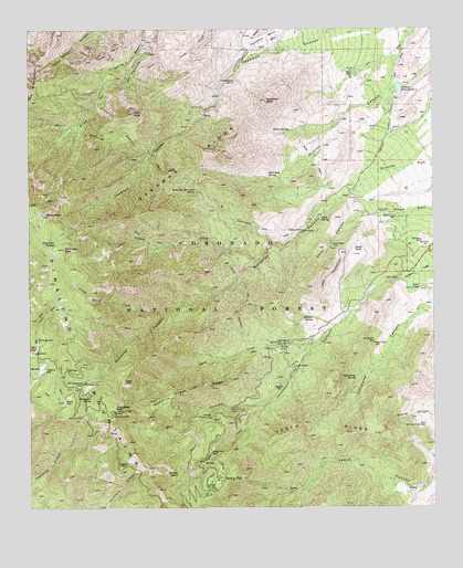
Mount Graham, AZ USGS Topographic Map
Click on map above to begin viewing in our Map Viewer.

This topographic map contains these locations and features:
Feature Name Type Latitude Longitude GNIS ID View Map
Adams FlatFlatN32.6556°W109.7990°482View Map
Angle OrchardLocaleN32.6615°W109.7929°658View Map
Arcadia CampgroundLocaleN32.6487°W109.8195°756View Map
Arcadia Recreation AreaParkN32.6487°W109.8192°22393View Map
Bench TankReservoirN32.6926°W109.7751°1235View Map
Carls SpringSpringN32.7007°W109.7854°2466View Map
Chinaberry SpringSpringN32.6587°W109.7749°2857View Map
Crazy Horse CreekStreamN32.6753°W109.8348°3551View Map
Cyclone HillSummitN32.6945°W109.7542°3667View Map
Deadman MesaSummitN32.7476°W109.8015°3767View Map
Deadman PeakSummitN32.7315°W109.8017°3769View Map
Deadman RidgeRidgeN32.7145°W109.8229°3770View Map
Eagle RockSummitN32.6581°W109.8462°4245View Map
East Spring Canyon DamDamN32.6465°W109.7534°4309View Map
Gibson Canyon - Deadman Hiline TrailTrailN32.6953°W109.8540°22501View Map
Gibson CreekStreamN32.6898°W109.8040°5007View Map
Goat TankReservoirN32.6820°W109.7574°5085View Map
Hagens PointCliffN32.6345°W109.8473°5504View Map
Heliograph PeakSummitN32.6501°W109.8490°5700View Map
Heliograph Ranger LookoutLocaleN32.6501°W109.8490°22519View Map
Heliograph SpringSpringN32.6540°W109.8565°5701View Map
Helldive SpringSpringN32.6748°W109.7879°5704View Map
High Peak CienegaSpringN32.6939°W109.8676°5797View Map
Hospital Flat CampgroundLocaleN32.6656°W109.8748°22530View Map
Jacobson CanyonValleyN32.6817°W109.7690°6342View Map
Johns DamDamN32.6845°W109.7617°6467View Map
Lady Bug Trail Three Hundred Twenty NineTrailN32.6406°W109.8029°22543View Map
Lebanon DitchCanalN32.7333°W109.7617°6941View Map
Lebanon Reservoir Number OneReservoirN32.7346°W109.7610°6942View Map
Marijilda CanyonValleyN32.7008°W109.7853°7704View Map
Marijilda Picnic GroundsParkN32.7009°W109.7873°22566View Map
Mineshaft WellWellN32.6681°W109.7692°8111View Map
Mount GrahamSummitN32.7017°W109.8715°5204View Map
Noon CreekStreamN32.6690°W109.7848°8689View Map
Noon Creek CampgroundLocaleN32.6678°W109.7970°22585View Map
Noon Creek Picnic GroundsParkN32.6673°W109.7979°22586View Map
Noon Creek RidgeRidgeN32.6548°W109.8292°8690View Map
Noon Creek TrailTrailN32.6573°W109.8234°22587View Map
Old Gibson Sawmill (historical)LocaleN32.6948°W109.8384°22592View Map
Pinaleno MountainsRangeN32.6409°W109.8437°9449View Map
Plain View PeakSummitN32.6928°W109.8648°9564View Map
Red Squirrel Refugium AreaReserveN32.7001°W109.8729°1956063View Map
Rincon SpringSpringN32.7234°W109.7946°10298View Map
Round the Mountain SpringSpringN32.7074°W109.8240°10526View Map
Round the Mountain TrailTrailN32.6903°W109.8137°10542View Map
S CanyonValleyN32.6942°W109.7992°10612View Map
Shannon CampgroundLocaleN32.6573°W109.8584°22653View Map
Shannon ParkParkN32.6576°W109.8590°11158View Map
Shannon Recreation AreaParkN32.6590°W109.8581°22654View Map
Slick Rock SpringSpringN32.7114°W109.8015°11430View Map
Snow FlatFlatN32.6534°W109.8645°11499View Map
Snow Flat Boy Scout CampParkN32.6537°W109.8640°22659View Map
South Canyon Dam TankReservoirN32.6953°W109.8017°22661View Map
Spring Canyon Dam TankReservoirN32.6487°W109.7580°22671View Map
Swift CanyonValleyN32.7009°W109.7709°12059View Map
The PinnaclesRidgeN32.7373°W109.8726°12363View Map
Trap PeakSummitN32.7281°W109.8429°12684View Map
Treasure ParkParkN32.6612°W109.8712°12698View Map
Turkey FlatPopulated PlaceN32.6309°W109.8212°12871View Map
Twilight CreekStreamN32.6515°W109.8029°12926View Map
Twilight SpringSpringN32.6348°W109.8300°12927View Map
Veach RidgeRidgeN32.6473°W109.7906°13201View Map
West Canyon Picnic GroundsParkN32.6509°W109.8134°22702View Map
Wet CanyonValleyN32.6515°W109.8045°13563View Map
Wet Canyon CampgroundLocaleN32.6515°W109.8137°22704View Map

Note: Coordinates in the location and feature list above are referenced to NAD83 datum.


Copyright (C) 2008-2024 Ryan Niemi / Sunset Dynamics ... All Rights Reserved