TopoQuest Logo
Do you find TopoQuest useful?
Help keep TopoQuest running and adding new maps/features by donating!
Bitcoin:  19c7KJd3qBynnjoSw5npx9KScwjBe4ifkT
Litecoin:  LXs6TkuXGGXo1vDsWCkWVdjQX94eUKd6ui
Home View Maps Find Maps Find Places Resources & Links


Mount Ida, Arkansas Topographic Map

USGS Map Title: Mount Ida, AR
USGS Map MRC: 34093E6
DRG (GeoTIFF) Download: o34093e6.tif


Neighboring USGS Topographic Map Quads:


  Brushy Creek Mountain, AR  
34093F7
 

  Sims, AR  
34093F6
 

  Story, AR  
34093F5
 

  Oden, AR  
34093E7
 

  Mount Ida, AR  
34093E6
 

  Reed Mountain, AR  
34093E5
 

  Polk Creek Mountain, AR  
34093D7
 

  Norman, AR  
34093D6
 

  Caddo Gap, AR  
34093D5


Map MRC Location:

N35°
W94°
N35°
W93°
H8 H7 H6 H5 H4 H3 H2 H1
G8 G7 G6 G5 G4 G3 G2 G1
F8 F7 F6 F5 F4 F3 F2 F1
E8 E7 E6 E5 E4 E3 E2 E1
D8 D7 D6 D5 D4 D3 D2 D1
C8 C7 C6 C5 C4 C3 C2 C1
B8 B7 B6 B5 B4 B3 B2 B1
A8 A7 A6 A5 A4 A3 A2 A1
N34°
W94°
N34°
W93°

Mount Ida, AR USGS 1:24K Topographic Map Preview:
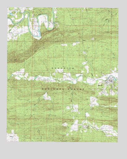
Mount Ida, AR USGS Topographic Map
Click on map above to begin viewing in our Map Viewer.

This topographic map contains these locations and features:
Feature Name Type Latitude Longitude GNIS ID View Map
Allen CreekStreamN34.6198°W93.7324°70428View Map
Amason CemeteryCemeteryN34.6131°W93.7032°70439View Map
Amerson CemeteryCemeteryN34.6137°W93.7030°63442View Map
Bates CemeteryCemeteryN34.5426°W93.6524°63447View Map
Ben Craven Elementary SchoolSchoolN34.5568°W93.6377°63448View Map
Big Cedar CreekStreamN34.5595°W93.7024°70658View Map
Cedar CreekStreamN34.6112°W93.7380°71071View Map
Church of ChristChurchN34.5543°W93.6380°63470View Map
City of Mount IdaCivilN34.5509°W93.6309°2404320View Map
Clear BranchStreamN34.6162°W93.6338°71159View Map
Crump CreekStreamN34.5209°W93.6613°71299View Map
Evening Light TabernacleChurchN34.5634°W93.6382°63479View Map
Faith TabernacleChurchN34.6057°W93.6710°63481View Map
First Assembly of God ChurchChurchN34.5523°W93.6319°63489View Map
Garrett CemeteryCemeteryN34.5593°W93.6319°63496View Map
Landmark Missionary Baptist ChurchChurchN34.5507°W93.6285°63523View Map
Little Cedar CreekStreamN34.5545°W93.6757°72376View Map
Lone Star School (historical)SchoolN34.6137°W93.6763°63531View Map
Martin CreekStreamN34.5573°W93.6502°72559View Map
MauldinLocaleN34.5926°W93.6657°74576View Map
MauldinPopulated PlaceN34.5940°W93.6660°63539View Map
Mauldin MountainRidgeN34.5954°W93.6985°72570View Map
Mauldin School (historical)SchoolN34.5926°W93.6710°63540View Map
Midway Pentecostal ChurchChurchN34.5262°W93.6849°63542View Map
MimosaPopulated PlaceN34.5040°W93.7435°63543View Map
Mimosa School (historical)SchoolN34.5034°W93.7435°63544View Map
Montgomery CountyCivilN34.5388°W93.6595°69168View Map
Montgomery County CourthouseBuildingN34.5579°W93.6327°63546View Map
Montgomery County Sheriff's OfficeBuildingN34.5577°W93.6326°2118973View Map
Mount IdaPopulated PlaceN34.5568°W93.6341°77718View Map
Mount Ida CemeteryCemeteryN34.5543°W93.6374°63549View Map
Mount Ida Church of GodChurchN34.5501°W93.6413°63550View Map
Mount Ida First Baptist ChurchChurchN34.5543°W93.6366°63551View Map
Mount Ida First United Methodist ChurchChurchN34.5559°W93.6355°63552View Map
Mount Ida High SchoolSchoolN34.5568°W93.6377°63553View Map
Mount Ida Post OfficePost OfficeN34.5599°W93.6340°84246View Map
Mount Ida Volunteer Fire DepartmentBuildingN34.5557°W93.6372°2116820View Map
Mountain Valley School (historical)SchoolN34.5245°W93.7010°63559View Map
Mullenix CemeteryCemeteryN34.6073°W93.7399°63561View Map
Oak Grove School (historical)SchoolN34.6229°W93.7324°63572View Map
Oak Hill CemeteryCemeteryN34.6223°W93.7391°63573View Map
Old Salyer CemeteryCemeteryN34.5590°W93.6552°63582View Map
OwleyPopulated PlaceN34.5143°W93.6621°63583View Map
Owley CemeteryCemeteryN34.5156°W93.6616°63584View Map
Owley ChurchChurchN34.5145°W93.6610°72971View Map
Owley School (historical)SchoolN34.5134°W93.6621°63585View Map
Rocky CemeteryCemeteryN34.5643°W93.7321°78205View Map
Rocky Shoals CampgroundLocaleN34.6120°W93.6971°74578View Map
Rocky Valley School (historical)SchoolN34.5595°W93.7138°63612View Map
Scott CemeteryCemeteryN34.5168°W93.6705°63617View Map
Southwest Emergency Medical Service Mount IdaBuildingN34.5533°W93.6385°2119065View Map
Township of Hazel (historical)CivilN34.5168°W93.6696°70100View Map
Township of South Fork (historical)CivilN34.5501°W93.6419°68893View Map
West SpringSpringN34.6026°W93.6362°74084View Map
West Spring BranchStreamN34.6248°W93.6369°74085View Map
Williams CreekStreamN34.5357°W93.6252°74162View Map

Note: Coordinates in the location and feature list above are referenced to NAD83 datum.


Copyright (C) 2008-2025 Ryan Niemi / Sunset Dynamics ... All Rights Reserved