TopoQuest Logo
Do you find TopoQuest useful?
Help keep TopoQuest running and adding new maps/features by donating!
Bitcoin:  19c7KJd3qBynnjoSw5npx9KScwjBe4ifkT
Litecoin:  LXs6TkuXGGXo1vDsWCkWVdjQX94eUKd6ui
Home View Maps Find Maps Find Places Resources & Links


Mount Morris, Illinois Topographic Map

USGS Map Title: Mount Morris, IL
USGS Map MRC: 42089A4
DRG (GeoTIFF) Download: o42089a4.tif


Neighboring USGS Topographic Map Quads:


  Forreston North, IL  
42089B5
 

  German Valley, IL  
42089B4
 

  Seward, IL  
42089B3
 

  Forreston South, IL  
42089A5
 

  Mount Morris, IL  
42089A4
 

  Oregon, IL  
42089A3
 

  Polo, IL  
41089H5
 

  Grand Detour, IL  
41089H4
 

  Daysville, IL  
41089H3


Map MRC Location:

N43°
W90°
N43°
W89°
H8 H7 H6 H5 H4 H3 H2 H1
G8 G7 G6 G5 G4 G3 G2 G1
F8 F7 F6 F5 F4 F3 F2 F1
E8 E7 E6 E5 E4 E3 E2 E1
D8 D7 D6 D5 D4 D3 D2 D1
C8 C7 C6 C5 C4 C3 C2 C1
B8 B7 B6 B5 B4 B3 B2 B1
A8 A7 A6 A5 A4 A3 A2 A1
N42°
W90°
N42°
W89°

Mount Morris, IL USGS 1:24K Topographic Map Preview:
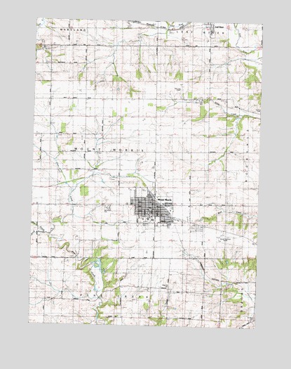
Mount Morris, IL USGS Topographic Map
Click on map above to begin viewing in our Map Viewer.

This topographic map contains these locations and features:
Feature Name Type Latitude Longitude GNIS ID View Map
Blackhawk Junior High SchoolSchoolN42.0453°W89.4354°1808186View Map
Camlin CemeteryCemeteryN42.0884°W89.3759°1705999View Map
Cedar Bluff School (historical)SchoolN42.1061°W89.4907°405731View Map
Cedar Hill CemeteryCemeteryN42.0159°W89.4240°1705995View Map
Center School (historical)SchoolN42.0950°W89.4137°405838View Map
Church of the BrethrenChurchN42.0445°W89.4407°1808206View Map
Coon Creek School (historical)SchoolN42.0781°W89.4821°406534View Map
David L Rahn Elementary SchoolSchoolN42.0439°W89.4387°1808210View Map
Dillehay ParkParkN42.0417°W89.4271°1808211View Map
Disciples United Methodist ChurchChurchN42.0498°W89.4451°1808212View Map
Evangelical Free ChurchChurchN42.0478°W89.4359°1808217View Map
Fairview School (historical)SchoolN42.1142°W89.4476°408234View Map
Hal Palmer ParkParkN42.0459°W89.4243°1808235View Map
Hillsdale School (historical)SchoolN42.0131°W89.4084°410293View Map
Leaf River Grade SchoolSchoolN42.1211°W89.4034°1808249View Map
Maple Grove School (historical)SchoolN42.0492°W89.4976°412952View Map
Mount MorrisPopulated PlaceN42.0503°W89.4312°414000View Map
Mount Morris City HallBuildingN42.0473°W89.4318°1808261View Map
Mount Morris Fire Protection DistrictBuildingN42.0466°W89.4323°2640469View Map
Mount Morris Police DepartmentBuildingN42.0456°W89.4355°2756865View Map
Mount Morris Post OfficePost OfficeN42.0483°W89.4350°1808262View Map
Mount Morris Public LibraryBuildingN42.0478°W89.4318°1808263View Map
New Junction School (historical)SchoolN42.0922°W89.4612°414437View Map
Oakwood CemeteryCemeteryN42.0484°W89.4582°1705997View Map
Ogle County AirportAirportN42.0369°W89.3952°427580View Map
Pine Creek School (historical)SchoolN42.0153°W89.4568°415697View Map
Plainview CemeteryCemeteryN42.0425°W89.4368°1705996View Map
Pleasant Valley School (historical)SchoolN42.0136°W89.3759°415914View Map
Saint Mary's CemeteryCemeteryN42.0034°W89.3768°1705994View Map
Silver Creek CemeteryCemeteryN42.0928°W89.4084°1705998View Map
Stonebraker School (historical)SchoolN42.0714°W89.4229°419175View Map
Sunset Hill Golf ClubLocaleN42.0556°W89.4384°1808307View Map
Township of Mount MorrisCivilN42.0710°W89.4517°429405View Map
Trinity Lutheran ChurchChurchN42.0456°W89.4284°1808308View Map
Victory School (historical)SchoolN42.0273°W89.4784°420307View Map
Village of Leaf RiverCivilN42.1236°W89.4041°2398406View Map
Village of Mount MorrisCivilN42.0488°W89.4296°2399413View Map
West Branch Pine CreekStreamN42.0367°W89.4898°420794View Map
West Grove AirportAirportN42.0981°W89.4191°427442View Map
WLFW-FM (Oregon)TowerN42.0706°W89.4512°428264View Map
Zickur ParkParkN42.0523°W89.4446°1808319View Map

Note: Coordinates in the location and feature list above are referenced to NAD83 datum.


Copyright (C) 2008-2025 Ryan Niemi / Sunset Dynamics ... All Rights Reserved