TopoQuest Logo
Do you find TopoQuest useful?
Help keep TopoQuest running and adding new maps/features by donating!
Bitcoin:  19c7KJd3qBynnjoSw5npx9KScwjBe4ifkT
Litecoin:  LXs6TkuXGGXo1vDsWCkWVdjQX94eUKd6ui
Home View Maps Find Maps Find Places Resources & Links


Mount Pisgah, South Carolina Topographic Map

USGS Map Title: Mount Pisgah, SC
USGS Map MRC: 34080E4
DRG (GeoTIFF) Download: o34080e4.tif


Neighboring USGS Topographic Map Quads:


  Taxahaw, SC  
34080F5
 

  Jefferson, SC  
34080F4
 

  Jefferson NE, SC  
34080F3
 

  Kershaw, SC  
34080E5
 

  Mount Pisgah, SC  
34080E4
 

  Angelus, SC  
34080E3
 

  Westville, SC  
34080D5
 

  Bethune NW, SC  
34080D4
 

  Bethune, SC  
34080D3


Map MRC Location:

N35°
W81°
N35°
W80°
H8 H7 H6 H5 H4 H3 H2 H1
G8 G7 G6 G5 G4 G3 G2 G1
F8 F7 F6 F5 F4 F3 F2 F1
E8 E7 E6 E5 E4 E3 E2 E1
D8 D7 D6 D5 D4 D3 D2 D1
C8 C7 C6 C5 C4 C3 C2 C1
B8 B7 B6 B5 B4 B3 B2 B1
A8 A7 A6 A5 A4 A3 A2 A1
N34°
W81°
N34°
W80°

Mount Pisgah, SC USGS 1:24K Topographic Map Preview:
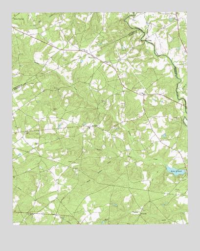
Mount Pisgah, SC USGS Topographic Map
Click on map above to begin viewing in our Map Viewer.

This topographic map contains these locations and features:
Feature Name Type Latitude Longitude GNIS ID View Map
Bermuda High GliderportAirportN34.6113°W80.4498°1251922View Map
Bethel ChurchChurchN34.6207°W80.3820°1220570View Map
Blakneys Bridge (historical)BridgeN34.5663°W80.3759°1235021View Map
Buffalo ChurchChurchN34.5543°W80.4901°1247046View Map
Buffalo Lookout TowerTowerN34.5479°W80.4840°1235033View Map
Buffalo School (historical)SchoolN34.5638°W80.4401°1235035View Map
Buffalo School (historical)SchoolN34.5785°W80.4212°1235034View Map
Crossroad ChurchChurchN34.6024°W80.4473°1247439View Map
Dew Fresh Pond Number OneReservoirN34.5026°W80.4278°1239439View Map
Dew Fresh Pond Number One Dam D-2509DamN34.5035°W80.4265°1239438View Map
Dew Fresh Pond Number TwoReservoirN34.5074°W80.3892°1239443View Map
Dew Fresh Pond Number Two Dam D-2511DamN34.5068°W80.3881°1239442View Map
Flat Creek School (historical)SchoolN34.6096°W80.4609°1241649View Map
Flat Creek School (historical)SchoolN34.6029°W80.4512°1241650View Map
Fork CreekStreamN34.6232°W80.4126°1247797View Map
Fran Bridge (historical)BridgeN34.5918°W80.3834°1235086View Map
Gates Ford School (historical)SchoolN34.5077°W80.4887°1235088View Map
Harrisons FordCrossingN34.6085°W80.4042°1235101View Map
Horton PondReservoirN34.5015°W80.4354°1223350View Map
Kershaw County Fire Station Buffalo Mount PisgahBuildingN34.5594°W80.4438°2578519View Map
Little Buffalo CreekStreamN34.5388°W80.4092°1223968View Map
McLeods Mill (historical)LocaleN34.6152°W80.4092°1235708View Map
Miller BridgeBridgeN34.6085°W80.4042°1224559View Map
Minton MillPopulated PlaceN34.5060°W80.4092°1246694View Map
Mount Oliver ChurchChurchN34.5063°W80.4879°1249633View Map
Mount PisgahPopulated PlaceN34.5582°W80.4451°1224761View Map
Mount Pisgah Buffalo Rescue SquadBuildingN34.5594°W80.4438°2739603View Map
Mount Pisgah ChurchChurchN34.5768°W80.4056°1249648View Map
Mount Pisgah DivisionCivilN34.5066°W80.4735°1938357View Map
Mount Pisgah Elementary SchoolSchoolN34.5574°W80.4448°1235154View Map
Pine Grove ChurchChurchN34.5982°W80.4409°1250109View Map
Pisgah School (historical)SchoolN34.5602°W80.4015°1235183View Map
Raley MillpondReservoirN34.5315°W80.3837°1250288View Map
Raleys Mill (historical)LocaleN34.5327°W80.3773°1235189View Map
Rocky CreekStreamN34.5802°W80.3817°1225974View Map
Sandy Grove ChurchChurchN34.5957°W80.4323°1250767View Map
Sidney Horton Pond Dam D-1074DamN34.5018°W80.4348°1239440View Map
South Buffalo CreekStreamN34.5385°W80.4231°1226754View Map
South Carolina Noname 28001 D-2510 DamDamN34.5315°W80.3773°1238184View Map
Stroud CemeteryCemeteryN34.5679°W80.4703°1226940View Map
Ubanks PondReservoirN34.6046°W80.4208°1239447View Map
Ubanks Pond Dam D-2512DamN34.6052°W80.4215°1239446View Map
William Holly PondReservoirN34.5580°W80.4661°1239445View Map
William Holly Pond Dam D-1073DamN34.5585°W80.4665°1239444View Map

Note: Coordinates in the location and feature list above are referenced to NAD83 datum.


Copyright (C) 2008-2025 Ryan Niemi / Sunset Dynamics ... All Rights Reserved