TopoQuest Logo
Do you find TopoQuest useful?
Help keep TopoQuest running and adding new maps/features by donating!
Bitcoin:  19c7KJd3qBynnjoSw5npx9KScwjBe4ifkT
Litecoin:  LXs6TkuXGGXo1vDsWCkWVdjQX94eUKd6ui
Home View Maps Find Maps Find Places Resources & Links


Mount Trumbull, Arizona Topographic Map

USGS Map Title: Mount Trumbull, AZ
USGS Map MRC: 36113D2
DRG (GeoTIFF) Download: o36113d2.tif


Neighboring USGS Topographic Map Quads:


  Russell Spring, AZ  
36113E3
 

  Moriah Knoll, AZ  
36113E2
 

  Hat Knoll, AZ  
36113E1
 

  Jones Hill, AZ  
36113D3
 

  Mount Trumbull, AZ  
36113D2
 

  Mount Trumbull NE, AZ  
36113D1
 

  Cold Spring, AZ  
36113C3
 

  Mount Logan, AZ  
36113C2
 

  Mount Trumbull SE, AZ  
36113C1


Map MRC Location:

N37°
W114°
N37°
W113°
H8 H7 H6 H5 H4 H3 H2 H1
G8 G7 G6 G5 G4 G3 G2 G1
F8 F7 F6 F5 F4 F3 F2 F1
E8 E7 E6 E5 E4 E3 E2 E1
D8 D7 D6 D5 D4 D3 D2 D1
C8 C7 C6 C5 C4 C3 C2 C1
B8 B7 B6 B5 B4 B3 B2 B1
A8 A7 A6 A5 A4 A3 A2 A1
N36°
W114°
N36°
W113°

Mount Trumbull, AZ USGS 1:24K Topographic Map Preview:
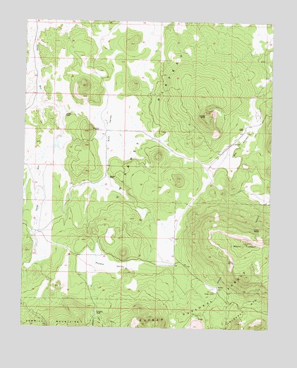
Mount Trumbull, AZ USGS Topographic Map
Click on map above to begin viewing in our Map Viewer.

This topographic map contains these locations and features:
Feature Name Type Latitude Longitude GNIS ID View Map
Coyote SpringSpringN36.4158°W113.1338°3501View Map
Craig RanchLocaleN36.4569°W113.1394°28153View Map
Craigs KnollSummitN36.4618°W113.1575°3540View Map
Crosby Detention DamDamN36.4516°W113.2358°22898View Map
Crosby ReservoirReservoirN36.4076°W113.2434°22899View Map
Crosby TankReservoirN36.4617°W113.2305°3587View Map
Crosby Tank ReservoirReservoirN36.4164°W113.2341°22900View Map
Joshua Crosby DamDamN36.4083°W113.2424°23021View Map
Kenworthy RanchLocaleN36.4558°W113.2119°6669View Map
Lake ValleyBasinN36.4464°W113.1469°6849View Map
Marshall RanchLocaleN36.4364°W113.2077°7727View Map
Mount TrumbullSummitN36.4100°W113.1382°12739View Map
Mount Trumbull Post Office (historical)Post OfficeN36.4122°W113.1758°44987View Map
Mount Trumbull WildernessReserveN36.4060°W113.1286°2035213View Map
Nixon Ranger StationLocaleN36.3894°W113.1527°8672View Map
Nixon SpringSpringN36.4022°W113.1466°8673View Map
Potato ValleyBasinN36.4016°W113.2088°9689View Map
Sawmill TankReservoirN36.3810°W113.2129°10985View Map
Sink ValleyValleyN36.4378°W113.2094°11358View Map
Witch Pool (historical)LakeN36.4500°W113.1674°23948View Map

Note: Coordinates in the location and feature list above are referenced to NAD83 datum.


Copyright (C) 2008-2025 Ryan Niemi / Sunset Dynamics ... All Rights Reserved