TopoQuest Logo
Do you find TopoQuest useful?
Help keep TopoQuest running and adding new maps/features by donating!
Bitcoin:  19c7KJd3qBynnjoSw5npx9KScwjBe4ifkT
Litecoin:  LXs6TkuXGGXo1vDsWCkWVdjQX94eUKd6ui
Home View Maps Find Maps Find Places Resources & Links


Mumper, Nebraska Topographic Map

USGS Map Title: Mumper, NE
USGS Map MRC: 41102G4
DRG (GeoTIFF) Download: o41102g4.tif


Neighboring USGS Topographic Map Quads:


  Beck Lake, NE  
41102H5
 

  Schoonover Lake, NE  
41102H4
 

  Black Lake, NE  
41102H3
 

  Bean Lake, NE  
41102G5
 

  Mumper, NE  
41102G4
 

  Hessey Lake, NE  
41102G3
 

  Richardson Lake, NE  
41102F5
 

  Crescent Lake, NE  
41102F4
 

  Deer Lake, NE  
41102F3


Map MRC Location:

N42°
W103°
N42°
W102°
H8 H7 H6 H5 H4 H3 H2 H1
G8 G7 G6 G5 G4 G3 G2 G1
F8 F7 F6 F5 F4 F3 F2 F1
E8 E7 E6 E5 E4 E3 E2 E1
D8 D7 D6 D5 D4 D3 D2 D1
C8 C7 C6 C5 C4 C3 C2 C1
B8 B7 B6 B5 B4 B3 B2 B1
A8 A7 A6 A5 A4 A3 A2 A1
N41°
W103°
N41°
W102°

Mumper, NE USGS 1:24K Topographic Map Preview:
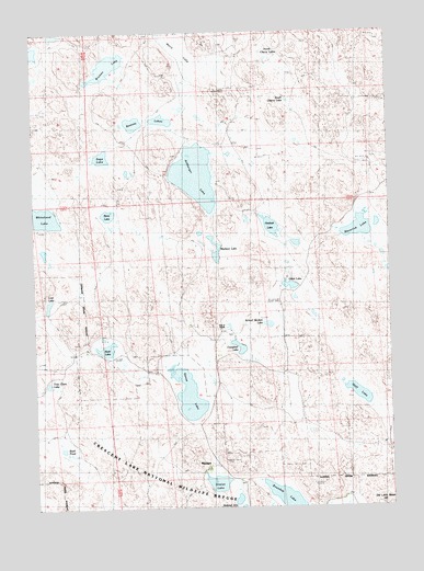
Mumper, NE USGS Topographic Map
Click on map above to begin viewing in our Map Viewer.

This topographic map contains these locations and features:
Feature Name Type Latitude Longitude GNIS ID View Map
Ashburger LakeLakeN41.8373°W102.4430°827092View Map
Boyd PondLakeN41.7655°W102.4912°1794558View Map
Breman LakeLakeN41.8659°W102.4738°827628View Map
Campbell LakeLakeN41.7920°W102.4285°827916View Map
Four D RanchLocaleN41.7966°W102.4344°1794557View Map
Gaff LakeLakeN41.7797°W102.3870°829438View Map
Gillet LakeLakeN41.8083°W102.4107°829521View Map
Gimlet LakeLakeN41.7564°W102.4368°829529View Map
Goose LakeLakeN41.7800°W102.4469°829581View Map
Heskett LakeLakeN41.8237°W102.4169°830035View Map
Lookout Tower Number 1TowerN41.7564°W102.4035°836077View Map
Lost LakeLakeN41.8039°W102.4951°830911View Map
Madison LakeLakeN41.8211°W102.4387°1794560View Map
Maverick LakeLakeN41.8227°W102.3862°831091View Map
Melis LakeSwampN41.8682°W102.4441°831197View Map
MumperPopulated PlaceN41.7614°W102.4402°835385View Map
Mumper Post Office (historical)Post OfficeN41.7614°W102.4402°1832299View Map
North Cherry LakesLakeN41.8685°W102.4175°831679View Map
Ramsay LakesLakeN41.8509°W102.4653°832442View Map
Reno LakeLakeN41.8272°W102.4741°832522View Map
Roundup LakeLakeN41.7526°W102.4132°832757View Map
Rush LakeLakeN41.7918°W102.4753°832783View Map
Sage LakeLakeN41.8423°W102.4761°832821View Map
School Number 60SchoolN41.7894°W102.4302°836936View Map
School Section LakeLakeN41.7981°W102.4182°833294View Map
South Cherry LakeLakeN41.8568°W102.4108°833570View Map
Tree Claim LakeLakeN41.7827°W102.4955°1794559View Map

Note: Coordinates in the location and feature list above are referenced to NAD83 datum.


Copyright (C) 2008-2025 Ryan Niemi / Sunset Dynamics ... All Rights Reserved