TopoQuest Logo
Do you find TopoQuest useful?
Help keep TopoQuest running and adding new maps/features by donating!
Bitcoin:  19c7KJd3qBynnjoSw5npx9KScwjBe4ifkT
Litecoin:  LXs6TkuXGGXo1vDsWCkWVdjQX94eUKd6ui
Home View Maps Find Maps Find Places Resources & Links


Munds Park, Arizona Topographic Map

USGS Map Title: Munds Park, AZ
USGS Map MRC: 34111H6
DRG (GeoTIFF) Download: o34111h6.tif


Neighboring USGS Topographic Map Quads:


  Dutton Hill, AZ  
35111A7
 

  Mountainaire, AZ  
35111A6
 

  Lower Lake Mary, AZ  
35111A5
 

  Wilson Mountain, AZ  
34111H7
 

  Munds Park, AZ  
34111H6
 

  Mormon Mountain, AZ  
34111H5
 

  Sedona, AZ  
34111G7
 

  Munds Mountain, AZ  
34111G6
 

  Stoneman Lake, AZ  
34111G5


Map MRC Location:

N35°
W112°
N35°
W111°
H8 H7 H6 H5 H4 H3 H2 H1
G8 G7 G6 G5 G4 G3 G2 G1
F8 F7 F6 F5 F4 F3 F2 F1
E8 E7 E6 E5 E4 E3 E2 E1
D8 D7 D6 D5 D4 D3 D2 D1
C8 C7 C6 C5 C4 C3 C2 C1
B8 B7 B6 B5 B4 B3 B2 B1
A8 A7 A6 A5 A4 A3 A2 A1
N34°
W112°
N34°
W111°

Munds Park, AZ USGS 1:24K Topographic Map Preview:
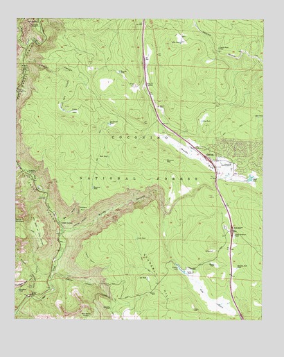
Munds Park, AZ USGS Topographic Map
Click on map above to begin viewing in our Map Viewer.

This topographic map contains these locations and features:
Feature Name Type Latitude Longitude GNIS ID View Map
A B Young TrailTrailN34.9689°W111.7499°25512View Map
Arts TankReservoirN34.9088°W111.6891°25774View Map
Beacon TankReservoirN34.8792°W111.6803°2090379View Map
Bee CanyonValleyN34.9159°W111.7277°26173View Map
Blowout TankReservoirN34.9776°W111.6978°26501View Map
Camp TankReservoirN34.9100°W111.6481°2090384View Map
Canyon TankReservoirN34.9956°W111.7097°2090411View Map
Casner CanyonValleyN34.8936°W111.7307°27331View Map
Casner Canyon Eleven TrailTrailN34.8925°W111.7207°37699View Map
Cave SpringSpringN34.9985°W111.7406°27386View Map
Cave Spring CampgroundLocaleN34.9964°W111.7393°27387View Map
Clay ParkFlatN34.8839°W111.6527°27689View Map
Clay TankReservoirN34.8881°W111.6656°2090381View Map
Coyote Park TankReservoirN34.9880°W111.6484°28120View Map
Coyote TankReservoirN34.9831°W111.6522°2090410View Map
Crazy ParkFlatN34.9617°W111.7213°28167View Map
Crazy Park CanyonValleyN34.9778°W111.7327°28168View Map
Crazy Park TankReservoirN34.9618°W111.7269°37732View Map
Deadwood TankReservoirN34.9563°W111.7036°28351View Map
Encinoso Picnic AreaParkN34.9256°W111.7354°28905View Map
Fenceline TankReservoirN34.9539°W111.6889°2090404View Map
Fern TankReservoirN34.9902°W111.6676°28976View Map
First Bench of Wilson MountainBenchN34.9122°W111.7393°29009View Map
Fixup TankReservoirN34.9669°W111.7097°2090406View Map
Fox TankReservoirN34.8750°W111.6677°29159View Map
Foxboro LakeReservoirN34.8985°W111.6692°29160View Map
Foxboro Lake DamDamN34.8984°W111.6690°37801View Map
Foxboro RanchLocaleN34.8950°W111.6607°29161View Map
Frog TankReservoirN34.9578°W111.6566°29217View Map
Geronimo Number Two TankReservoirN34.9375°W111.6743°37815View Map
Geronimo TankReservoirN34.9412°W111.6747°29311View Map
Grasshopper PointAreaN34.8870°W111.7313°37820View Map
Grasshopper Point CampgroundLocaleN34.8872°W111.7315°41184View Map
Hoels WashStreamN34.9796°W111.7469°2434629View Map
Hope TankReservoirN34.9767°W111.7161°2090409View Map
Indian GardensPopulated PlaceN34.9139°W111.7271°30342View Map
Indian PointCliffN34.9000°W111.7138°30352View Map
KQST-FM (Sedona)TowerN34.8822°W111.6804°45235View Map
Lee TankReservoirN34.8924°W111.6833°30931View Map
Little Antelope InterchangeCrossingN34.9122°W111.6410°31026View Map
Little Antelope TankReservoirN34.8967°W111.6385°31028View Map
Manzanita CampgroundLocaleN34.9364°W111.7449°31490View Map
Mason TankReservoirN34.8981°W111.6497°31561View Map
Midgely Bridge Picnic AreaParkN34.8850°W111.7427°37939View Map
Midgley BridgeBridgeN34.8853°W111.7424°31841View Map
Mud TankReservoirN34.9595°W111.6283°32144View Map
Munds CanyonValleyN34.9117°W111.7260°32189View Map
Munds ParkFlatN34.9420°W111.6579°32192View Map
Munds ParkPopulated PlaceN34.9456°W111.6402°32193View Map
Munds Park Census Designated PlaceCensusN34.9382°W111.6318°2408889View Map
Munds Park Community ChurchChurchN34.9417°W111.6559°2671255View Map
Munds Park InterchangeCrossingN34.9422°W111.6535°32194View Map
Munds Park Post OfficePost OfficeN34.9416°W111.6507°2670494View Map
Munds Park Rest AreaLocaleN34.9534°W111.6713°37956View Map
Munds Park SubstationLocaleN34.9367°W111.6510°37957View Map
Munds TankReservoirN34.9453°W111.6619°41179View Map
Oak Creek CanyonValleyN34.9125°W111.7268°32433View Map
Oakwood Country ClubLocaleN34.9395°W111.6421°43199View Map
Odell DamDamN34.9334°W111.6335°37972View Map
Odell LakeReservoirN34.9348°W111.6314°32479View Map
Pinewood Country ClubLocaleN34.9370°W111.6432°41182View Map
Pinewood Fire DepartmentBuildingN34.9401°W111.6409°2672562View Map
Powerline TankReservoirN34.9556°W111.6792°2090403View Map
Rainbow Trailer ParkPopulated PlaceN34.9039°W111.7269°2669833View Map
Rock TankReservoirN34.9428°W111.7041°33741View Map
Rocky TankReservoirN34.9722°W111.7139°2090408View Map
Roundup TankReservoirN34.9299°W111.7117°33847View Map
Schnebly HillSummitN34.8820°W111.6763°34134View Map
Schnebly Hill VistaLocaleN34.8897°W111.7032°34135View Map
Schnebly Number Two TankReservoirN34.8818°W111.6945°38059View Map
Schnebly TankReservoirN34.8800°W111.7024°34136View Map
School House Picnic GroundLocaleN34.9350°W111.7443°41181View Map
Section Sixteen TankReservoirN34.9522°W111.7386°2090405View Map
Sedona Fire District Station 5BuildingN34.9112°W111.7285°2672582View Map
Skeleton Park TankReservoirN34.8969°W111.6385°34486View Map
Steamboat TankReservoirN34.8872°W111.7491°34811View Map
Stuck TankReservoirN34.8897°W111.6294°2090380View Map
Super TankReservoirN34.9683°W111.7206°2090407View Map
Surveyor CanyonValleyN34.9803°W111.7468°34989View Map
Telephone TankReservoirN34.9847°W111.7114°38104View Map
Thomas Point TankReservoirN34.9825°W111.7357°38107View Map
Thompson LadderTrailN34.9150°W111.7174°35283View Map
Thompsons Ladder FourteenTrailN34.9167°W111.7154°38110View Map
Thompsons PointCliffN34.9184°W111.7182°35290View Map
West Fork Oak CreekStreamN34.9872°W111.7460°35991View Map
Willard Mountain TankReservoirN34.9661°W111.6486°2090383View Map
Willard SpringSpringN34.9736°W111.6814°36207View Map
Willard Springs InterchangeCrossingN34.9814°W111.6860°38172View Map
Wilson CanyonValleyN34.8853°W111.7424°36287View Map
Wilson Mountain TrailTrailN34.8997°W111.7402°36291View Map

Note: Coordinates in the location and feature list above are referenced to NAD83 datum.


Copyright (C) 2008-2024 Ryan Niemi / Sunset Dynamics ... All Rights Reserved