TopoQuest Logo
Do you find TopoQuest useful?
Help keep TopoQuest running and adding new maps/features by donating!
Bitcoin:  19c7KJd3qBynnjoSw5npx9KScwjBe4ifkT
Litecoin:  LXs6TkuXGGXo1vDsWCkWVdjQX94eUKd6ui
Home View Maps Find Maps Find Places Resources & Links


Nasja Mesa, Utah Topographic Map

USGS Map Title: Nasja Mesa, UT
USGS Map MRC: 37110B8
DRG (GeoTIFF) Download: o37110b8.tif


Neighboring USGS Topographic Map Quads:


  Sooner Bench, UT  
37111C1
 

  Davis Gulch, UT  
37110C8
 

  The Rincon, UT  
37110C7
 

  Navajo Point, UT  
37111B1
 

  Nasja Mesa, UT  
37110B8
 

  Wilson Creek, UT  
37110B7
 

  Cathedral Canyon, UT  
37111A1
 

  Rainbow Bridge, UT  
37110A8
 

  Navajo Begay, UT  
37110A7


Map MRC Location:

N38°
W111°
N38°
W110°
H8 H7 H6 H5 H4 H3 H2 H1
G8 G7 G6 G5 G4 G3 G2 G1
F8 F7 F6 F5 F4 F3 F2 F1
E8 E7 E6 E5 E4 E3 E2 E1
D8 D7 D6 D5 D4 D3 D2 D1
C8 C7 C6 C5 C4 C3 C2 C1
B8 B7 B6 B5 B4 B3 B2 B1
A8 A7 A6 A5 A4 A3 A2 A1
N37°
W111°
N37°
W110°

Nasja Mesa, UT USGS 1:24K Topographic Map Preview:
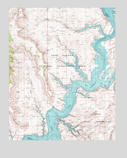
Nasja Mesa, UT USGS Topographic Map
Click on map above to begin viewing in our Map Viewer.

This topographic map contains these locations and features:
Feature Name Type Latitude Longitude GNIS ID View Map
Anasazi CanyonValleyN37.1480°W110.9421°1425104View Map
Cottonwood CanyonValleyN37.2333°W110.8757°1426897View Map
Cottonwood GulchValleyN37.1944°W110.9210°1426924View Map
Fiftymile PointCapeN37.2428°W110.9843°1427926View Map
Hidden Passage CanyonValleyN37.1755°W110.9290°1450384View Map
Hoskaninni Company RoadTrailN37.1983°W110.8924°1450396View Map
Karnaba Spring (historical)SpringN37.1797°W110.8804°1437846View Map
Lehi CanyonValleyN37.1339°W110.9207°1429578View Map
Llewellyn GulchValleyN37.2300°W110.9285°1429841View Map
Melody Spring (historical)SpringN37.1733°W110.8857°1437847View Map
Moepitz CanyonValleyN37.1355°W110.9299°1430398View Map
Music Temple Bar (historical)BarN37.1628°W110.9235°1450436View Map
Nasja MesaSummitN37.1583°W110.9007°1430642View Map
Navajo ValleyValleyN37.1511°W110.9649°1437841View Map
Oak CanyonValleyN37.1305°W110.9540°1430903View Map
Reflection CanyonValleyN37.1755°W110.9110°1437850View Map
Register RockIslandN37.2425°W110.8751°1436220View Map
San Juan Placer Claim (historical)LocaleN37.1983°W110.8929°1450488View Map
San Juan RiverStreamN37.1797°W110.9007°1454998View Map
San Juan ValleyValleyN37.1797°W110.9007°1455002View Map
Twilight ArchArchN37.1397°W110.9603°2071342View Map
Twilight CanyonValleyN37.1278°W110.9607°1436530View Map

Note: Coordinates in the location and feature list above are referenced to NAD83 datum.


Copyright (C) 2008-2025 Ryan Niemi / Sunset Dynamics ... All Rights Reserved