TopoQuest Logo
Do you find TopoQuest useful?
Help keep TopoQuest running and adding new maps/features by donating!
Bitcoin:  19c7KJd3qBynnjoSw5npx9KScwjBe4ifkT
Litecoin:  LXs6TkuXGGXo1vDsWCkWVdjQX94eUKd6ui
Home View Maps Find Maps Find Places Resources & Links


Nast, Colorado Topographic Map

USGS Map Title: Nast, CO
USGS Map MRC: 39106C5
DRG (GeoTIFF) Download: o39106c5.tif


Neighboring USGS Topographic Map Quads:


  Crooked Creek Pass, CO  
39106D6
 

  Mount Jackson, CO  
39106D5
 

  Mount of the Holy Cross, CO  
39106D4
 

  Meredith, CO  
39106C6
 

  Nast, CO  
39106C5
 

  Homestake Reservoir, CO  
39106C4
 

  Thimble Rock, CO  
39106B6
 

  Mount Champion, CO  
39106B5
 

  Mount Massive, CO  
39106B4


Map MRC Location:

N40°
W107°
N40°
W106°
H8 H7 H6 H5 H4 H3 H2 H1
G8 G7 G6 G5 G4 G3 G2 G1
F8 F7 F6 F5 F4 F3 F2 F1
E8 E7 E6 E5 E4 E3 E2 E1
D8 D7 D6 D5 D4 D3 D2 D1
C8 C7 C6 C5 C4 C3 C2 C1
B8 B7 B6 B5 B4 B3 B2 B1
A8 A7 A6 A5 A4 A3 A2 A1
N39°
W107°
N39°
W106°

Nast, CO USGS 1:24K Topographic Map Preview:
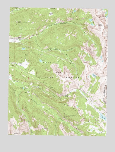
Nast, CO USGS Topographic Map
Click on map above to begin viewing in our Map Viewer.

This topographic map contains these locations and features:
Feature Name Type Latitude Longitude GNIS ID View Map
Brady LakeLakeN39.3674°W106.5017°202679View Map
Carter and Moran Tunnels MineMineN39.3578°W106.5353°1684272View Map
Carter CreekStreamN39.3611°W106.5514°179510View Map
Carter LakeLakeN39.3724°W106.5425°179768View Map
Chapman TunnelTunnelN39.2511°W106.6092°202676View Map
Coffeepot ParkFlatN39.3750°W106.5754°169542View Map
Cunningham CreekStreamN39.3455°W106.5920°179771View Map
Cunningham Tunnel MineMineN39.2953°W106.5448°1684273View Map
Diemer LakeLakeN39.3345°W106.6072°179766View Map
Elk Wallow CampgroundLocaleN39.3439°W106.6125°179765View Map
Fryingpan-Arkansaw North Side Collection SystemLocaleN39.2692°W106.5450°179788View Map
Granite AditTunnelN39.2683°W106.5536°179790View Map
Granite CreekStreamN39.2686°W106.5617°179785View Map
Hell GapGapN39.2900°W106.5542°179786View Map
Henderson ParkFlatN39.3689°W106.5753°179767View Map
Horseshoe Bend RanchLocaleN39.2958°W106.6039°179778View Map
Ivanhoe CreekStreamN39.2975°W106.6039°179780View Map
Ivanhoe DamDamN39.2730°W106.5111°199412View Map
Ivanhoe LakeReservoirN39.2730°W106.5111°202680View Map
Last Chance TrailTrailN39.3719°W106.6203°202662View Map
Lily Pad CreekStreamN39.2580°W106.5448°179791View Map
Lily Pad LakeLakeN39.2558°W106.5194°179792View Map
Lyle CreekStreamN39.2911°W106.5298°179782View Map
Lyle LakeLakeN39.3096°W106.5168°179781View Map
Middle Cunningham CreekStreamN39.3330°W106.5559°179774View Map
Mormon CreekStreamN39.3594°W106.5409°179770View Map
Mormon LakeLakeN39.3275°W106.5081°179769View Map
Mount NastSummitN39.2511°W106.6120°179783View Map
NastPopulated PlaceN39.2917°W106.6014°179779View Map
Nast E LakeLakeN39.2960°W106.6062°179777View Map
Nast TunnelTunnelN39.2652°W106.5470°179789View Map
Reed CreekStreamN39.3719°W106.6173°179505View Map
Savage LakesLakeN39.3617°W106.5209°179794View Map
Sellar LakeLakeN39.3232°W106.5852°179772View Map
Sellar ParkFlatN39.3192°W106.6056°179776View Map
Sellar PeakSummitN39.3119°W106.5636°179775View Map
Sopris LakeLakeN39.3712°W106.5030°179793View Map
South Cunningham CreekStreamN39.3339°W106.5609°179773View Map
South Fork Fryingpan RiverStreamN39.3058°W106.6223°179784View Map
Wildcat MountainSummitN39.2794°W106.5428°179787View Map

Note: Coordinates in the location and feature list above are referenced to NAD83 datum.


Copyright (C) 2008-2025 Ryan Niemi / Sunset Dynamics ... All Rights Reserved