TopoQuest Logo
Do you find TopoQuest useful?
Help keep TopoQuest running and adding new maps/features by donating!
Bitcoin:  19c7KJd3qBynnjoSw5npx9KScwjBe4ifkT
Litecoin:  LXs6TkuXGGXo1vDsWCkWVdjQX94eUKd6ui
Home View Maps Find Maps Find Places Resources & Links


Belle Meade NW, Florida Topographic Map

USGS Map Title: Belle Meade NW, FL
USGS Map MRC: 26081B6
DRG (GeoTIFF) Download: o26081b6.tif


Neighboring USGS Topographic Map Quads:


  Bonita Springs, FL  
26081C7
 

  Corkscrew SW, FL  
26081C6
 

  Corkscrew SE, FL  
26081C5
 

  Naples North, FL  
26081B7
 

  Belle Meade NW, FL  
26081B6
 

  Belle Meade NE, FL  
26081B5
 

  Naples South, FL  
26081A7
 

  Belle Meade, FL  
26081A6
 

  Belle Meade SE, FL  
26081A5


Map MRC Location:

N27°
W82°
N27°
W81°
H8 H7 H6 H5 H4 H3 H2 H1
G8 G7 G6 G5 G4 G3 G2 G1
F8 F7 F6 F5 F4 F3 F2 F1
E8 E7 E6 E5 E4 E3 E2 E1
D8 D7 D6 D5 D4 D3 D2 D1
C8 C7 C6 C5 C4 C3 C2 C1
B8 B7 B6 B5 B4 B3 B2 B1
A8 A7 A6 A5 A4 A3 A2 A1
N26°
W82°
N26°
W81°

Belle Meade NW, FL USGS 1:24K Topographic Map Preview:
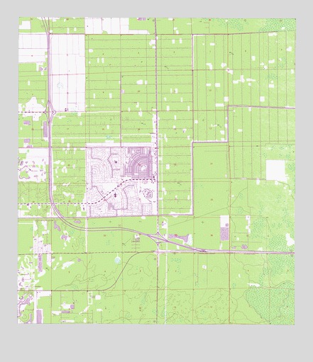
Belle Meade NW, FL USGS Topographic Map
Click on map above to begin viewing in our Map Viewer.

This topographic map contains these locations and features:
Feature Name Type Latitude Longitude GNIS ID View Map
Allen Chapel ChurchChurchN26.1351°W81.6359°301323View Map
Baptist Spanish MissionChurchN26.1365°W81.6373°301322View Map
Catholic Church HallChurchN26.1462°W81.6359°301321View Map
Collier County Emergency Medical Services Station 46BuildingN26.2111°W81.7490°2661774View Map
Collier County Emergency Medical Services Station 70BuildingN26.1828°W81.7042°2661772View Map
Collier County Emergency Medical Services Station 71BuildingN26.2289°W81.6334°2661775View Map
Collier County Emergency Medical Services Station 75BuildingN26.1442°W81.7176°2661767View Map
Collier County Public Library Estates BranchBuildingN26.2288°W81.6326°2450895View Map
Collier County Public Library Golden Gate City BranchBuildingN26.1828°W81.7043°2450896View Map
Collier County Sheriff's Office District 2 Golden Gate SubstationBuildingN26.1831°W81.7035°2333531View Map
Crokscrew Christian AcademySchoolN26.1604°W81.7373°299775View Map
Endless Summer Mobile Home ParkPopulated PlaceN26.1562°W81.7353°2450959View Map
Florida Highway Patrol StationBuildingN26.1553°W81.6706°2333733View Map
Florida Panther National Wildlife Refuge HeadquartersBuildingN26.1586°W81.6844°2092914View Map
Golden GatePopulated PlaceN26.1879°W81.6951°283146View Map
Golden Gate Census Designated PlaceCensusN26.1844°W81.7031°2402531View Map
Golden Gate Community CenterBuildingN26.1842°W81.7033°2450892View Map
Golden Gate Elementary School South CampusSchoolN26.1890°W81.7084°297432View Map
Golden Gate Fire Control and Rescue District Station 70BuildingN26.1828°W81.7042°2131502View Map
Golden Gate Fire Control and Rescue District Station 72BuildingN26.1539°W81.6833°2131699View Map
Golden Gate Fire Department Control and Rescue District Station 71BuildingN26.2280°W81.6324°2131698View Map
Golden Gate Middle SchoolSchoolN26.1778°W81.7051°297474View Map
Golden Gate Post OfficePost OfficeN26.1857°W81.6884°2768167View Map
Miles Grant Country ClubLocaleN26.1445°W81.7227°2450908View Map
Mizner Country ClubLocaleN26.1467°W81.7464°2450911View Map
Monastery Golf and Country ClubLocaleN26.1470°W81.7315°2450913View Map
Naples Christian AcademySchoolN26.1734°W81.7193°299777View Map
Naples DivisionCivilN26.1678°W81.7362°1935862View Map
North Naples Fire Control and Rescue District Station 46BuildingN26.2111°W81.7491°2131693View Map
Oyster Creek Golf and Country ClubLocaleN26.1886°W81.7461°2450937View Map
Physicians Regional Medical Center Pine RidgeHospitalN26.2140°W81.7327°2662526View Map
Saint Ann Catholic ParishChurchN26.1337°W81.6345°301284View Map
Saint John Neumann High SchoolSchoolN26.1721°W81.7128°299776View Map
Seacrest SchoolSchoolN26.1379°W81.7240°299774View Map
Southwind Mobile VillagePopulated PlaceN26.1561°W81.7399°2450955View Map
Sunrise AcademySchoolN26.1262°W81.7293°299773View Map
Tender Loving Care Non - Emergency Medical TransportBuildingN26.1560°W81.6778°2661769View Map
VineyardsPopulated PlaceN26.2279°W81.7093°1853298View Map
Vineyards Census Designated PlaceCensusN26.2279°W81.7280°2402971View Map
WSGL-FM (Naples)TowerN26.1265°W81.7215°309075View Map

Note: Coordinates in the location and feature list above are referenced to NAD83 datum.


Copyright (C) 2008-2025 Ryan Niemi / Sunset Dynamics ... All Rights Reserved