TopoQuest Logo
Do you find TopoQuest useful?
Help keep TopoQuest running and adding new maps/features by donating!
Bitcoin:  19c7KJd3qBynnjoSw5npx9KScwjBe4ifkT
Litecoin:  LXs6TkuXGGXo1vDsWCkWVdjQX94eUKd6ui
Home View Maps Find Maps Find Places Resources & Links


New Hill, North Carolina Topographic Map

USGS Map Title: New Hill, NC
USGS Map MRC: 35078F8
DRG (GeoTIFF) Download: o35078f8.tif


Neighboring USGS Topographic Map Quads:


  Farrington, NC  
35079G1
 

  Green Level, NC  
35078G8
 

  Cary, NC  
35078G7
 

  Merry Oaks, NC  
35079F1
 

  New Hill, NC  
35078F8
 

  Apex, NC  
35078F7
 

  Moncure, NC  
35079E1
 

  Cokesbury, NC  
35078E8
 

  Fuquay-Varina, NC  
35078E7


Map MRC Location:

N36°
W79°
N36°
W78°
H8 H7 H6 H5 H4 H3 H2 H1
G8 G7 G6 G5 G4 G3 G2 G1
F8 F7 F6 F5 F4 F3 F2 F1
E8 E7 E6 E5 E4 E3 E2 E1
D8 D7 D6 D5 D4 D3 D2 D1
C8 C7 C6 C5 C4 C3 C2 C1
B8 B7 B6 B5 B4 B3 B2 B1
A8 A7 A6 A5 A4 A3 A2 A1
N35°
W79°
N35°
W78°

New Hill, NC USGS 1:24K Topographic Map Preview:
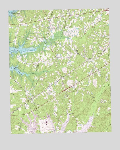
New Hill, NC USGS Topographic Map
Click on map above to begin viewing in our Map Viewer.

This topographic map contains these locations and features:
Feature Name Type Latitude Longitude GNIS ID View Map
Apex Fire Department Station 2BuildingN35.6734°W78.9316°2638944View Map
Beaver Creek Commons Shopping CenterLocaleN35.7443°W78.8751°2455188View Map
Big BranchStreamN35.6429°W78.9281°981342View Map
Big BranchStreamN35.6690°W78.8845°981362View Map
BonsalPopulated PlaceN35.6604°W78.9736°1019252View Map
Cedar Rock ChurchChurchN35.6627°W78.9700°982900View Map
Christian ChapelChurchN35.7043°W78.9153°983170View Map
Clark and Sears Store (historical)LocaleN35.7368°W78.8895°1951439View Map
Deck AirparkAirportN35.7408°W78.9255°997964View Map
FriendshipPopulated PlaceN35.6988°W78.8997°985427View Map
Gerringer-Goodman DamDamN35.7452°W78.9164°999341View Map
Gerringer-Goodman PondReservoirN35.7452°W78.9164°999340View Map
Little BranchStreamN35.6743°W78.8781°988548View Map
Mount Zion ChurchChurchN35.7077°W78.9164°990657View Map
New HillPopulated PlaceN35.6810°W78.9356°1021627View Map
New Hill Post OfficePost OfficeN35.6811°W78.9346°2774217View Map
Oak Grove ChurchChurchN35.6610°W78.8970°991379View Map
Olive ChapelChurchN35.7318°W78.9478°991637View Map
Olive Chapel Elementary SchoolSchoolN35.7348°W78.8943°2454678View Map
Pleasant Plains ChurchChurchN35.7049°W78.8853°992561View Map
Reedy BranchStreamN35.7232°W78.9361°993179View Map
Township of BuckhornCivilN35.6607°W78.9337°1027259View Map
Utley CreekStreamN35.6377°W78.9017°996566View Map

Note: Coordinates in the location and feature list above are referenced to NAD83 datum.


Copyright (C) 2008-2025 Ryan Niemi / Sunset Dynamics ... All Rights Reserved