TopoQuest Logo
Do you find TopoQuest useful?
Help keep TopoQuest running and adding new maps/features by donating!
Bitcoin:  19c7KJd3qBynnjoSw5npx9KScwjBe4ifkT
Litecoin:  LXs6TkuXGGXo1vDsWCkWVdjQX94eUKd6ui
Home View Maps Find Maps Find Places Resources & Links


New Salem, Texas Topographic Map

USGS Map Title: New Salem, TX
USGS Map MRC: 31094H8
DRG (GeoTIFF) Download: o31094h8.tif


Neighboring USGS Topographic Map Quads:


  Griffin, TX  
32095A1
 

  Gum Springs, TX  
32094A8
 

  Berryhill Creek, TX  
32094A7
 

  New Summerfield, TX  
31095H1
 

  New Salem, TX  
31094H8
 

  Laneville, TX  
31094H7
 

  Atoy, TX  
31095G1
 

  Reklaw, TX  
31094G8
 

  Cushing, TX  
31094G7


Map MRC Location:

N32°
W95°
N32°
W94°
H8 H7 H6 H5 H4 H3 H2 H1
G8 G7 G6 G5 G4 G3 G2 G1
F8 F7 F6 F5 F4 F3 F2 F1
E8 E7 E6 E5 E4 E3 E2 E1
D8 D7 D6 D5 D4 D3 D2 D1
C8 C7 C6 C5 C4 C3 C2 C1
B8 B7 B6 B5 B4 B3 B2 B1
A8 A7 A6 A5 A4 A3 A2 A1
N31°
W95°
N31°
W94°

New Salem, TX USGS 1:24K Topographic Map Preview:
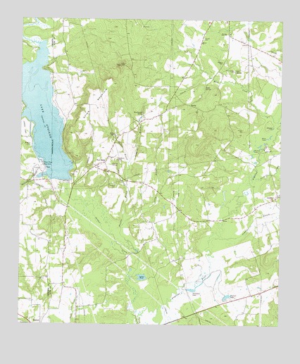
New Salem, TX USGS Topographic Map
Click on map above to begin viewing in our Map Viewer.

This topographic map contains these locations and features:
Feature Name Type Latitude Longitude GNIS ID View Map
AnadarkoPopulated PlaceN31.9282°W94.8763°1377936View Map
Anadarko CreekStreamN31.9349°W94.8891°1329509View Map
Autry BranchStreamN31.9160°W94.9505°1329874View Map
Black LakeLakeN31.9521°W94.8819°1330764View Map
Buckner DamDamN31.8868°W94.9002°1861244View Map
Buckner LakeReservoirN31.8866°W94.9003°1331516View Map
Cambell BranchStreamN31.9093°W94.9088°1331925View Map
Compton BranchStreamN31.9410°W94.9483°1333193View Map
Cool SpringsSpringN31.9796°W94.8972°1333276View Map
Cool Springs CemeteryCemeteryN31.9793°W94.8977°1333277View Map
Devereaux LakeLakeN31.8895°W94.9179°1334284View Map
FairviewPopulated PlaceN31.9104°W94.9344°2034827View Map
Garrett CemeteryCemeteryN31.9927°W94.9124°1336413View Map
Harmon LakeLakeN31.9467°W94.8883°1337357View Map
Indian PondLakeN31.8951°W94.9408°1338450View Map
Johnson LakeLakeN31.9560°W94.8788°1338800View Map
Lake StrikerReservoirN31.9614°W94.9897°1376322View Map
Lake StrikerReservoirN31.9352°W94.9752°1861247View Map
Lake Striker DamDamN31.9352°W94.9752°1861246View Map
Medford CemeteryCemeteryN31.9327°W94.9547°1341317View Map
Miracle ChurchChurchN31.9907°W94.9135°1341728View Map
Mush CreekStreamN31.9588°W94.8769°1342290View Map
New SalemPopulated PlaceN31.9416°W94.9597°1378751View Map
New Salem Volunteer Fire DepartmentBuildingN31.9427°W94.9756°2655476View Map
Pearson SpringSpringN31.9407°W94.9565°1343736View Map
Post Oak Grove ChurchChurchN31.9943°W94.9016°1344412View Map
Quinn MountainSummitN31.9691°W94.9641°1344667View Map
Riddle SpringsSpringN31.9721°W94.9116°1345196View Map
Sanders BranchStreamN31.9410°W94.9480°1346556View Map
Skinner SpringSpringN31.9527°W94.9541°1347207View Map
Striker CreekStreamN31.8757°W94.9424°1348001View Map
Vaughn CemeteryCemeteryN31.9552°W94.8933°1349209View Map
Washburn SpringSpringN31.9428°W94.9539°1349511View Map
Weatherford SpringSpringN31.9618°W94.9416°1349573View Map
Wheelus BranchStreamN31.9043°W94.9433°1349910View Map
Wiggins CemeteryCemeteryN31.9485°W94.9955°1350045View Map
Wiggins CemeteryCemeteryN31.9829°W94.9033°1350046View Map

Note: Coordinates in the location and feature list above are referenced to NAD83 datum.


Copyright (C) 2008-2025 Ryan Niemi / Sunset Dynamics ... All Rights Reserved