TopoQuest Logo
Do you find TopoQuest useful?
Help keep TopoQuest running and adding new maps/features by donating!
Bitcoin:  19c7KJd3qBynnjoSw5npx9KScwjBe4ifkT
Litecoin:  LXs6TkuXGGXo1vDsWCkWVdjQX94eUKd6ui
Home View Maps Find Maps Find Places Resources & Links


Nimrod Dam, Arkansas Topographic Map

USGS Map Title: Nimrod Dam, AR
USGS Map MRC: 34093H2
DRG (GeoTIFF) Download: o34093h2.tif


Neighboring USGS Topographic Map Quads:


  Danville Mountain, AR  
35093A3
 

  Ola, AR  
35093A2
 

  Casa, AR  
35093A1
 

  Plainview, AR  
34093H3
 

  Nimrod Dam, AR  
34093H2
 

  Nimrod, AR  
34093H1
 

  Steve, AR  
34093G3
 

  Nimrod SW, AR  
34093G2
 

  Nimrod SE, AR  
34093G1


Map MRC Location:

N35°
W94°
N35°
W93°
H8 H7 H6 H5 H4 H3 H2 H1
G8 G7 G6 G5 G4 G3 G2 G1
F8 F7 F6 F5 F4 F3 F2 F1
E8 E7 E6 E5 E4 E3 E2 E1
D8 D7 D6 D5 D4 D3 D2 D1
C8 C7 C6 C5 C4 C3 C2 C1
B8 B7 B6 B5 B4 B3 B2 B1
A8 A7 A6 A5 A4 A3 A2 A1
N34°
W94°
N34°
W93°

Nimrod Dam, AR USGS 1:24K Topographic Map Preview:
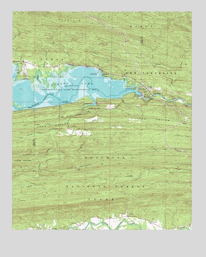
Nimrod Dam, AR USGS Topographic Map
Click on map above to begin viewing in our Map Viewer.

This topographic map contains these locations and features:
Feature Name Type Latitude Longitude GNIS ID View Map
Anderson BranchStreamN34.9576°W93.2299°70442View Map
Ark SchoolSchoolN34.8793°W93.1524°70460View Map
Bales Ford (historical)CrossingN34.9559°W93.1968°65186View Map
Big Brushy CreekStreamN34.9320°W93.2221°70657View Map
Brush CreekStreamN34.9470°W93.1971°70856View Map
Carden CreekStreamN34.9670°W93.1896°71009View Map
Carden Point Public Use AreaParkN34.9651°W93.1913°76532View Map
Carter CemeteryCemeteryN34.9651°W93.2452°71019View Map
Carter Cove Public Use AreaParkN34.9612°W93.2388°76537View Map
Carter CreekStreamN34.9654°W93.2477°76538View Map
Carters Chapel (historical)ChurchN34.9656°W93.2435°67865View Map
Cedar BranchStreamN34.9668°W93.1427°71052View Map
Cedar Gap BranchStreamN34.9598°W93.1724°71086View Map
Chinquapin MountainSummitN34.9226°W93.1535°65199View Map
County Line Recreation AreaParkN34.9634°W93.1882°76691View Map
Cove MountainSummitN34.9104°W93.2055°71251View Map
Dawson School (historical)SchoolN34.9637°W93.2216°67882View Map
Dry ForkStreamN34.8781°W93.1874°71452View Map
Earl BranchStreamN34.9656°W93.2091°71489View Map
English BranchStreamN34.9598°W93.2191°71561View Map
Fourche JunctionPopulated PlaceN34.9565°W93.1571°71667View Map
Guest BranchStreamN34.9323°W93.2074°71848View Map
Little Brushy CreekStreamN34.9368°W93.2121°72373View Map
New Mount Everett ChurchChurchN34.9518°W93.1607°52721View Map
Nimrod DamDamN34.9520°W93.1607°75801View Map
Nimrod LakeReservoirN34.9509°W93.2436°75802View Map
Nimrod State Game Management AreaParkN34.9540°W93.2146°72872View Map
Ola MountainRidgeN34.9934°W93.1982°72927View Map
Project Point Recreation AreaParkN34.9548°W93.1624°78102View Map
Quarry Cove Recreation AreaParkN34.9562°W93.1657°78122View Map
River Road Recreation AreaParkN34.9504°W93.1563°78183View Map
The NarrowsGapN34.9501°W93.1438°65236View Map
Township of Dawson (historical)CivilN34.9626°W93.2335°67884View Map
Township of Howell (historical)CivilN34.9543°W93.1377°65220View Map
Township of McCool (historical)CivilN34.8834°W93.2418°65231View Map
Valley Home ChurchChurchN34.8751°W93.2191°73955View Map
Westlake School (historical)SchoolN34.9326°W93.1596°65273View Map

Note: Coordinates in the location and feature list above are referenced to NAD83 datum.


Copyright (C) 2008-2025 Ryan Niemi / Sunset Dynamics ... All Rights Reserved