TopoQuest Logo
Do you find TopoQuest useful?
Help keep TopoQuest running and adding new maps/features by donating!
Bitcoin:  19c7KJd3qBynnjoSw5npx9KScwjBe4ifkT
Litecoin:  LXs6TkuXGGXo1vDsWCkWVdjQX94eUKd6ui
Home View Maps Find Maps Find Places Resources & Links


Nocona, Texas Topographic Map

USGS Map Title: Nocona, TX
USGS Map MRC: 33097G6
DRG (GeoTIFF) Download: o33097g6.tif


Neighboring USGS Topographic Map Quads:


  Fleetwood, OK  
33097H7
 

  Prairie Valley School, TX  
33097H6
 

  Spanish Fort, TX  
33097H5
 

  Belcherville, TX  
33097G7
 

  Nocona, TX  
33097G6
 

  Bonita, TX  
33097G5
 

  Buzzard Roost Knob, TX  
33097F7
 

  Montague, TX  
33097F6
 

  Saint Jo, TX  
33097F5


Map MRC Location:

N34°
W98°
N34°
W97°
H8 H7 H6 H5 H4 H3 H2 H1
G8 G7 G6 G5 G4 G3 G2 G1
F8 F7 F6 F5 F4 F3 F2 F1
E8 E7 E6 E5 E4 E3 E2 E1
D8 D7 D6 D5 D4 D3 D2 D1
C8 C7 C6 C5 C4 C3 C2 C1
B8 B7 B6 B5 B4 B3 B2 B1
A8 A7 A6 A5 A4 A3 A2 A1
N33°
W98°
N33°
W97°

Nocona, TX USGS 1:24K Topographic Map Preview:
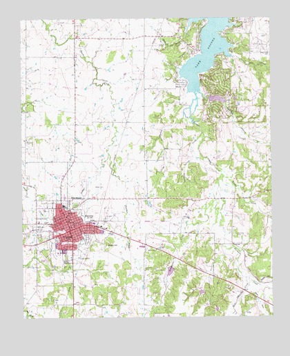
Nocona, TX USGS Topographic Map
Click on map above to begin viewing in our Map Viewer.

This topographic map contains these locations and features:
Feature Name Type Latitude Longitude GNIS ID View Map
American Legion ParkParkN33.7909°W97.7423°2028888View Map
Barefoot BranchStreamN33.8448°W97.6617°1351508View Map
Benton CemeteryCemeteryN33.8051°W97.7092°1351898View Map
Benton HillSummitN33.7809°W97.7073°1351899View Map
Blue MoundSummitN33.8004°W97.7256°1352475View Map
Church of ChristChurchN33.7893°W97.7261°2023149View Map
Church of the NazareneChurchN33.7901°W97.7259°2023150View Map
City of NoconaCivilN33.7836°W97.7302°2411259View Map
Deep DrawValleyN33.7629°W97.6369°1355818View Map
Devils GulchValleyN33.8738°W97.6646°1355960View Map
Dripping Springs CreekStreamN33.8270°W97.6597°1356262View Map
Eagle Point CemeteryCemeteryN33.8640°W97.6800°1356540View Map
First Baptist ChurchChurchN33.7907°W97.7270°2023143View Map
Greenbrier CemeteryCemeteryN33.7707°W97.6889°1358394View Map
Greenbrier CreekStreamN33.8073°W97.6520°1358395View Map
Jones HollowValleyN33.8373°W97.6655°1360400View Map
Keck CemeteryCemeteryN33.8682°W97.6489°1360505View Map
Lake NoconaReservoirN33.8652°W97.6560°1363948View Map
Leisure LakeReservoirN33.8413°W97.6519°1863661View Map
Leisure Lake DamDamN33.8418°W97.6553°1863660View Map
Molsbee CemeteryCemeteryN33.8240°W97.7478°1363044View Map
NoconaPopulated PlaceN33.7868°W97.7259°1363946View Map
Nocona Airport (historical)AirportN33.7740°W97.7384°1387249View Map
Nocona City HallBuildingN33.7883°W97.7254°2753948View Map
Nocona Elementary SchoolSchoolN33.7840°W97.7259°2007453View Map
Nocona General HospitalHospitalN33.7775°W97.7327°2015725View Map
Nocona High SchoolSchoolN33.7979°W97.7311°2007454View Map
Nocona HillsPopulated PlaceN33.8517°W97.6501°2652414View Map
Nocona Hills Census Designated PlaceCensusN33.8524°W97.6435°2586963View Map
Nocona Hills Volunteer Fire Department and Emergency Medical ServiceBuildingN33.8360°W97.6407°2551819View Map
Nocona Middle SchoolSchoolN33.7962°W97.7300°2007455View Map
Nocona Police DepartmentBuildingN33.7881°W97.7258°2738916View Map
Nocona Post OfficePost OfficeN33.7908°W97.7279°2731374View Map
Nocona Volunteer Fire DepartmentBuildingN33.7882°W97.7261°2551495View Map
Polecat CreekStreamN33.8593°W97.6470°1365536View Map
Redbud CreekStreamN33.8098°W97.6500°1366269View Map
Robinson CemeteryCemeteryN33.7848°W97.6431°1366616View Map
Saint Josephs Catholic ChurchChurchN33.7870°W97.7245°2023148View Map
Shady Grove CemeteryCemeteryN33.8601°W97.6259°1368018View Map
Simmons CemeteryCemeteryN33.8240°W97.6375°1368295View Map
Snake HillSummitN33.7662°W97.6275°1368545View Map
Soil Conservation Service Debris Basin 122ReservoirN33.7505°W97.6776°1863434View Map
Soil Conservation Service Debris Basin 122 DamDamN33.7518°W97.6770°1863433View Map
Soil Conservation Service Site 9 DamDamN33.7718°W97.6753°1863206View Map
Soil Conservation Service Site 9 ReservoirReservoirN33.7698°W97.6765°1863207View Map
South Ward SchoolSchoolN33.7840°W97.7259°1368798View Map
West Farmers CreekStreamN33.7665°W97.6386°1371121View Map

Note: Coordinates in the location and feature list above are referenced to NAD83 datum.


Copyright (C) 2008-2025 Ryan Niemi / Sunset Dynamics ... All Rights Reserved